
2026
3(87)
Andrzej Szymon Borkowski*, Klaudia Zelkowska**,
Małgorzata Żach***
BIM in assessing the suitability of historic fortifications
for military purposes, using the example of the gunpowder laboratory
at Boyen Fortress in Giżycko
DOI: 10.37190/arc260308
© by the Author/Authors. Licensee WUST.
Published in open access. CC BY-NC license.
Abstract
Building Information Modelling (BIM) is nding increasingly widespread application in the documentation, analysis and conservation of historic
buildings, enabling the creation of digital models which can then be used as a basis for a variety of spatial analyses. In the context of fortications, the
ability to use such models to assess their potential suitability in defence scenarios is of particular signicance. This article uses the example of the gun-
powder laboratory at Boyen Fortress in Giżycko (Poland) to illustrate the application of a simplied BIM model as a tool to support the analysis of the
structure’s relationship with the surrounding terrain and the conceptual evaluation of various terrain modications, such as trenches. A digital model of
the structure and its surroundings, supplemented by spatial analyses, enabled the assessment of spatial conditions, the identication of potential threat
directions, and the comparison of possible solutions for the location and appearance of earthworks. Due to the limitations of the BIM environment in
modelling complex terrain geometry at the conceptual stage, generative articial intelligence tools were used to visualise variants of potential earth-
works. The results obtained indicate that even simplied BIM models can provide a useful basis for variant analyses and the documentation of historic
structures. At the same time, articial intelligence-based tools are primarily used in the early stages of conceptual work, supporting the decision-making
process by rapidly presenting possible solutions whilst maintaining their illustrative nature.
Key words: BIM, Boyen Fortress, point cloud, trench, articial intelligence, gunpowder laboratory
Introduction
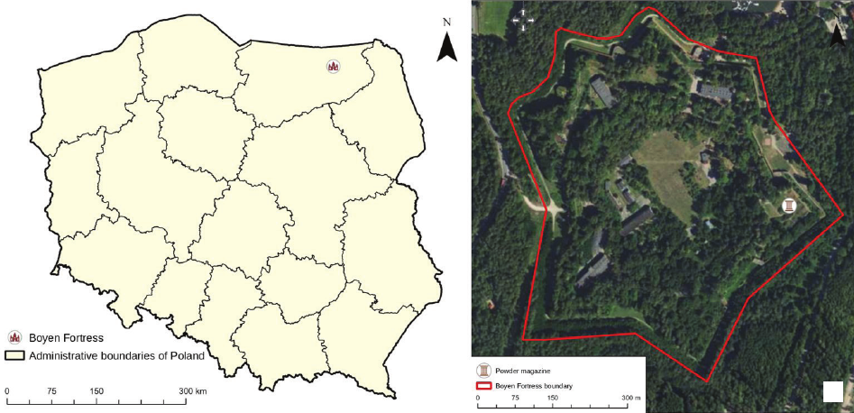
The authors’ focus is on a highly signicant example of
Prussian fortications – Boyen Fortress, situated in Gi życ-
ko, in the north-eastern part of Poland, in the Warmian-Ma-
surian Voivodeship (Fig. 1a) – and on methods of digital
surveying using Building Information Modelling (BIM)
technology. The fortress is situated between two large lakes
(Niegocin and Kisajno) and is one of the region’s most im-
portant historic sites (Krahel 2003). The gunpowder labo-
ratory, which is the subject of detailed research, is located
in the eastern part of the complex (Fig. 1b). In the 19
th
-cen-
tury functional layout of the fortress, this building served
as a site for the preparation of explosives and ammunition,
and its function diered from that of the military gunpow-
der store, which at Boyen Fortress was situated in the court-
yard of the Światło Bastion. The laboratory is characterised
by a distinctive design that can be described as being dug
into the ground; that is, from a bird’s-eye view, only the
corridor leading to the nine rooms is visible. This design
served, amongst other things, to protect the fortress’s other
structures in the event of an explosion (Twierdza Boyen
Gi życko n.d.).
Historic sites, such as Boyen Fortress, should be digi-
tised for their own preservation, given their cultural value.
BIM enables the creation of digital models of various his-
toric structures that reect their actual structure and charac-
*
ORCID:
0000-0002-7013-670X.
Faculty of Geodesy and Car -
tography, Warsaw University of Technology, Poland, e-mail: andrzej.
borkowski@pw.edu.pl
**
ORCID:
0009-0003-5226-0859.
Faculty of Geodesy and Car-
tography, Warsaw University of Technology, Poland.
***
ORCID:
0009-0000-2397-0366.
Faculty of Geodesy and Car-
tography, Warsaw University of Technology, Poland.
80 Andrzej Szymon Borkowski, Klaudia Zelkowska, Małgorzata Żach
teristics. Such models serve not only as documentation of
the current state of preservation, but also as a tool facilitat-
ing subsequent renovation, revitalisation or reconstruction
in the event of damage caused by human activity or natural
forces (Borkowski, Olszewska 2024). Creating a model us-
ing BIM preserves knowledge of the structure’s appearance
and condition, which, in the event of damage, would al-
low for the reconstruction of a historically valuable build-
ing, but also enable an assessment of the suitability of the
now-listed structure for contemporary military and defence
purposes. There are many dierent ways in which existing
historical infrastructure can be utilised for these purposes.
One of these is to design a trench as a simulation of poten-
tial defensive operations during wartime.
The aim of the authors is to present a methodology for
using a simplied BIM model, combining photogram-
metric data from unmanned aerial vehicles (UAVs) with
a variant analysis of site interventions supported by gen-
erative articial intelligence (AI) tools, in relation to his-
toric fortication structures. The case study focuses on the
gunpowder magazine at Boyen Fortress, for which digital
documentation of the external condition and an analysis
of illustrative conceptual intervention options have been
proposed, within the context of the debate on the state’s
defence readiness, whilst giving absolute priority to the
protection of the historic structure.
It is not the authors’ intention to advocate the active
military use of historic fortications. Nor does this paper
constitute an encouragement to undertake interventions that
would alter the substance of the historic monument. The
authors maintain that the protection of cultural heritage re-
mains the overriding priority. Any considerations regarding
the potential use of historic sites in crisis scenarios are pure-
ly of a hypothetical planning nature.
The BIM digital model fulls a dual role in this study.
Firstly, it serves as documentation of the site’s state of pres-
ervation. This function is purely conservation-related and
is independent of any further analyses. Secondly, the model
serves as a tool for a preliminary, conceptual spatial assess-
ment of possible on-site interventions. The second function
takes on signicance in the context of the ongoing debate in
Poland regarding the state’s defence readiness and in light
of the Regulation of the Minister of the Interior and Ad-
ministration of 2025 on protective and concealed structures
(Rozporządzenie… 2025).
It should be emphasised that variant analysis in a digital
environment is, by its very nature, intended to minimise the
risk of actual, irreversible interventions in a historic monu-
ment. It allows for the assessment of alternatives and their
consequences even before any on-site actions are under-
taken. In this sense, the use of BIM does not conict with
the mission of heritage conservation, but rather supports
it. It provides conservationists, defence services and deci-
sion-makers with a risk assessment tool.
The innovative contribution of this work does not lie
in the UAV data acquisition technology itself, nor in the
conversion of point clouds into a Revit model. These pro-
cedures are well documented in the relevant literature (Bor-
kowski, Kubrat 2024). The original contribution consists
of three elements. The rst of these is the integration of
variant analysis of conceptual site interventions with the
BIM model of the historic fortication. The second ele
ment
Fig. 1. Location of Boyen Fortress: a) its position in relation to the administrative boundaries of Poland and its provinces (elaborated by M. Żach,
K. Zelkowska based on the State Boundary Register of the General Directorate for Geodesy, Cartography and Cadastre [GUGiK];
https://www.geoportal.gov.pl/), b) location of the gunpowder laboratory in relation to the boundaries of Boyen Fortress (elaborated by M. Żach,
K. Zelkowska based on the GUGiK orthophoto map; https://www.geoportal.gov.pl/)
Il. 1. Lokalizacja Twierdzy Boyen: a) położenie na tle granic administracyjnych Polski i województw (oprac. M. Żach, K. Zelkowska
na podstawie Państwowego Rejestru Granic GUGiK; https://www.geoportal.gov.pl/), b) położenie laboratorium prochowego na tle granic
Twierdzy Boyen (oprac. M. Żach, K. Zelkowska na podstawie ortofotomapy GUGiK; https://www.geoportal.gov.pl/)
ba
BIMinassessingthesuitabilityofhistoricforticationsformilitarypurposes 81
is the use of generative articial intelligence tools, such as
Gemini 2.5 Flash Image (Nano Banana Pro) and GPT. These
tools were utilised to supplement the BIM environment in
areas where it exhibits signicant limitations. This primarily
concerns the modelling of complex terrain geometry in Re-
vit. The third element is a critical analysis of the limitations
of this hybrid methodology in conservation applications.
State of research
The eld of digital documentation of historic buildings
within the BIM environment has been developing for near-
ly two decades. Heritage Building Information Modelling
(HBIM) was introduced by Maurice Murphy and his co-au-
thors (Murphy, McGovern and Pavia 2009) as an extension
of the BIM methodology to include historic buildings, whose
geometry and construction do not conform to standard com-
ponent libraries. Subsequent work has focused on develop-
ing libraries of parametric elements for historic architecture
(Dore, Murphy 2017), the integration of data from terrestrial
laser scanning and photogrammetry (López et al. 2018), as
well as the challenges associated with the level of detail and
reliability of historical models (Penjor et al. 2024).
The number of studies on the application of BIM and
HBIM in the documentation of historic buildings is steadi-
ly increasing; however, the issue of using simplied BIM
models to assess the potential suitability of such buildings
in the context of modern defence remains a poorly explored
topic. In particular, issues combining spatial analysis based
on such a model with conceptual variations in the use of
existing terrain and structures are rarely addressed.
Methods
Unmanned aerial vehicles are now a widely used and
cost-eective tool for acquiring high-resolution data, as,
compared to methods based on, for example, satellite data,
they oer the possibility of acquiring data quickly and at
relatively low cost (Liu et al. 2022). This study utilised
a point cloud of the Boyen Fortress gunpowder laborato-
ry acquired during a ight with a DJI Mini 3 drone. Ap-
proximately 300 high-resolution images were captured and
subsequently processed photogrammetrically to produce
a three-dimensional point cloud depicting the gunpowder
laboratory and its immediate surroundings. The resulting
average resolution (GSD, Ground Sampling Distance) was
1.71 cm/pixel, which enabled a high-quality representation
of the object to be obtained. Following processing of the
point cloud in Agisoft software, a point cloud comprising
5,876,161 points was obtained. Due to the absence of an
RTK (Real-Time Kinematic) module in the drone used, the
point cloud was positioned in the WGS84 coordinate sys-
tem with a total error of 1.197 m.
The data processing began by importing the photo-
graphs into Agisoft and performing the image alignment
stage using the Align Photos tool. In this step, the software
searched for common points between the photographs,
identifying control points, and then calculated the orien-
tation and position of the camera for each shot. On this
basis, a preliminary, low-resolution point cloud was gen-
erated, which served as the basis for further processing. In
addition, during the scan of the terrain, photopoints were
utilised, which also served as an aid during the photo align-
ment process. In the next step, a dense point cloud was gen-
erated for further processing.
The resulting point cloud was imported into Autodesk
ReCap, where it underwent initial renement. At this stage,
a transformation to the local reference system (0,0,0) was
carried out, as working with geodetic coordinates can cause
reading and performance issues within the Autodesk Revit
environment. At the same time, the point cloud was man-
ually cleaned by removing noise irrelevant to the analysis,
in particular vegetation such as trees. After cleaning, the
point cloud was exported to .e57 format and imported into
CloudCompare.
In CloudCompare, the orientation of the point cloud was
corrected by correctly setting the reference plane. The
point
cloud was then exported in two formats: LAS and as an ASCII
text le. The LAS le was re-imported into Autodesk Re-
Cap and converted to the .rcp format, suitable for use in
Auto desk Revit. The point cloud prepared in this way was
imported into Revit using the “centre-to-centre” insertion
setting. An ASCII text le containing the point coordinates,
which were used to create the terrain model, was also im-
ported into Revit. It is important to maintain the correct le
structure and to set the separators to commas when import-
ing in CloudCompare, so that the point coordinates are cor-
rectly recognised during import.
Based on the imported point cloud, a simplied model
of the gunpowder laboratory was created, using the point
cloud as a measurement reference for determining the ele-
vations and geometry of the walls and ceiling. The model
was then rened to include basic elements such as doors
and windows, and materials were assigned to key compo-
nents. It should be emphasised, however, that the model is
for illustrative purposes only and does not fully capture the
details, as the photographic data was obtained from a bird’s-
eye view, which limits the accuracy of the representation of
vertical elements and façade details. The model was visu-
alised using Revit and Lumion. After integrating the mod-
elled building with the site, an integrated BIM model was
produced, serving as the basis for further analysis; the next
stage involves developing an excavation variant within the
modelled structure. During the development of the trench
simulation visualisations, two articial intelligence-based
tools were used to generate and manipulate images.
The trench visualisations were created in the ChatGPT
environment using the GPT model (OpenAI) and in Gemi-
ni 2.5 Flash Image, commonly known as Nano Banana Pro
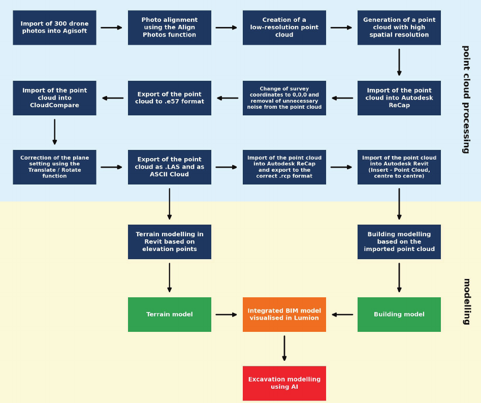
(Google). The individual stages of the methodology em-
ployed, covering data acquisition, data processing, the de-
velopment of the BIM model and the generation of visualisa-
tions of the variants, are summarised in a owchart (Fig. 2).
Trenches as a defensive structure
Trenches are earthworks constituting an anthropogen-
ic feature of the landscape (Franczak, Jucha 2015). They
enable relatively safe movement during shelling, as well
as the conduct of combat operations. The method of con-
82 Andrzej Szymon Borkowski, Klaudia Zelkowska, Małgorzata Żach
In this paper, the trench is treated as an exemplary, hy-
pothetical site intervention, serving as a test case to assess
the suitability of a simplied BIM model for the conceptu-
al variation of defensive solutions and for evaluating their
spatial and conservation implications.
Results
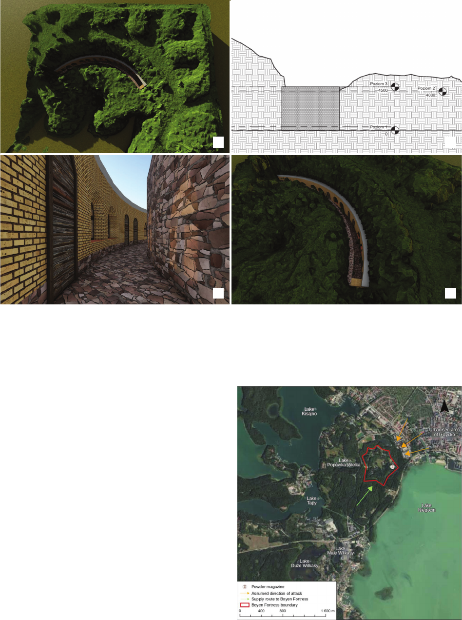
The simplied model of the gunpowder laboratory
(Fig. 3a–d) reects the external geometry of the building,
the topography of the surrounding moat and the relation-
ship between the building’s massing and ground level.
However, it is important to clearly highlight the method-
ological limitations of the representation. The photogram-
metric data were acquired exclusively from a drone. By its
very nature, this precludes direct mapping of the interior of
the structure, in particular the corridor leading to the nine
laboratory rooms. The underground section of the building
remains outside the range of the point cloud obtained from
a UAV ight without LiDAR. This is a signicant limita-
tion, as it is precisely this part of the building that is key
to its historical function. However, this limitation is inher-
structing trenches depends on many dierent factors, such
as the type of subsoil, the topography, the anticipated con-
struction time and the available labour. Trenches are often
constructed in the form of a zigzagging trench, which pro-
vides protection in the event that the enemy penetrates the
interior of the trench (Twierdza Włocławek 2025). At the
same time, the method of constructing trenches is regulated
by applicable regulations, which specify their basic form,
structure and permissible dimensions. In accordance with
the Regulation of the Minister of the Interior and Admini-
stration, trenches are constructed as narrow excavations with
a broken plan, with or without a cover, with temporary shor-
ing made, for example, of wooden formwork or sandbags, or
without shoring, whilst maintaining the natural slope
angle.
The regulations also specify the permissible dimensions of
trenches, which, in the case of shored solutions, include
a height of 150–220 cm and a width ranging from approx-
imately 80–100 cm at the base to 100–120 cm at the top of
the covering, whilst for trenches without formwork or cov-
ering, the height is approximately 140 cm and the width is
greater at the top, resulting from the use of the natural slope
angle (Rozporządzenie… 2025).
Fig. 2. Diagram of creating a model from a point cloud using photographs obtained by flying a DJI Mini drone (elaborated by M. Żach, K. Zelkowska)
Il. 2. Schemat utworzenia modelu z chmury punktów ze zdjęć pozyskanych w wyniku nalotu dronem DJI Mini (oprac. M. Żach, K. Zelkowska)
BIMinassessingthesuitabilityofhistoricforticationsformilitarypurposes 83
ent to the methodology adopted. A complete representation
of the interior would require supplementary ground-based
laser scanning (TLS) and interior scanning. The model
presented in this paper serves as a building-terrain model
rather than a full HBIM model. This is a deliberate choice.
The cross-sections shown in Figure 3c therefore illustrate
the relationship between the building’s structure and the
surrounding moat, rather than its internal functional lay-
out. A key outcome of the work carried out is the ability
to use the developed BIM model as digital documentation
of the building’s external condition. It records the geome-
try of the gunpowder laboratory and its relationship with
the surrounding terrain at the time the data was collected;
thus, in the event of partial or total destruction caused by
military action, natural disasters or deterioration over time,
the model can facilitate renovation or reconstruction work.
As part of the assessment of the military potential of the
Boyen Fortress gunpowder laboratory, simulations were
carried out to explore the possibility of transforming the
site by creating a visualisation of a trench. A variant anal-
ysis was conducted on the immediate surroundings of the
facility, taking into account the terrain, existing greenery,
spatial conditions and possible attack scenarios.
A threat scenario has been adopted in which the direction
of a potential attack is from the north-east (Fig. 4). From
the selected alternative location of the trench, the Boyen
Fortress area directly adjoins the built-up area of Giżycko,
Fig. 4. Visualisation of the attack scenario against the background
of an orthophotomap (elaborated by M. Żach, K. Zelkowska
based on an orthophotomap;
https://www.geoportal.gov.pl/)
Il. 4. Wizualizacja scenariusza ataku na tle ortofotomapy
(oprac. M. Żach, K. Zelkowska na podstawie ortofotomapy;
https://www.geoportal.gov.pl/)
Fig. 3. Model of the gunpowder laboratory at Boyen Fortress: a) topography, b) interior of the building, c) cross-section in Revit,
d) model of the Boyen Fortress gunpowder laboratory in Giżycko, including the topography (elaborated by M. Żach, K. Zelkowska)
Il. 3. Model laboratorium prochowego Twierdzy Boyen: a) ukształtowanie terenu, b) wewnętrzna część budynku, c) przekrój w programie Revit,
d) model laboratorium prochowego Twierdzy Boyen w Giżycku wraz z ukształtowaniem terenu (oprac. M. Żach, K. Zelkowska)
a
b
c
d
84 Andrzej Szymon Borkowski, Klaudia Zelkowska, Małgorzata Żach
making this direction one of the most accessible in terms of
transport links and potentially the most vulnerable to an ad-
vance by enemy forces. The scenario assumed that, follow-
ing the capture of the town, the Boyen Fortress area could
serve as one of the last points of resistance. Furthermore,
a key factor inuencing the choice of the trench’s location
is the natural terrain barriers surrounding the fortress. To
the east and north-west, the fortress area lies in close prox-
imity to large lakes (Niegocin and Kisajno). These signi-
cantly restrict direct access to the fort and hinder the con-
duct of land manoeuvres. From the south-west, a potential
advance towards the fortress is possible, though it is also
hampered by the presence of smaller lakes, such as Tajty,
Duże Wilkasy and Małe Wilkasy, which constitute addi-
tional natural obstacles. At the same time, from a broader
regional perspective, the northern and north-eastern direc-
tions are areas from which, geographically speaking, forc-
es posing a potential threat from beyond Poland’s borders
could move into Polish territory; in a hypothetical threat
scenario, this justies the potential location of the trench.
Furthermore, it should be noted that, from the southern side,
despite the presence of terrain obstacles, communication is
possible; and in the assumed siege scenario, the transport
routes located there could serve as a logistical base and fa-
cilitate supplies to the fortress area.
The appearance of trenches – that is, their form, shape
and length – depends on many factors, the key ones being
the terrain conditions, the time available for construction
and their intended function. Trenches can full several ba-
sic functions, including combat, defence and communica-
tion. However, two types of trenches can be distinguished:
ring trenches, which mark the front lines, and communi-
cation trenches, which connect them (Doyle 2019). As part
of the variant analysis carried out, two potential locations
for a trench were identied in the immediate vicinity of
the gunpowder laboratory building. Using articial intelli-
gence and based on the attached .jpg image of the gunpow-
der laboratory model (Fig. 3a), two variants of the trench’s
location and appearance were generated. The process of
generating the visualisations was based on descriptive text
prompts, which took into account the trench’s alignment,
its relationship with the terrain, the proximity to the gun-
powder laboratory building, and general characteristics
of earthworks, such as a zigzag shape or the shielding of
positions. The generated visualisations are for illustrative
purposes only. They serve to illustrate the spatial dierenc-
es between the variants. The geometric parameters of the
trenches adopted at the stage of generating prompts for the
AI tools were consistent with the dimensions specied in
the Regulation of the Minister of the Interior and Adminis-
tration of 2025. This applies to heights of 150–220 cm and
widths of 80–120 cm for the shored variants (Rozporządze-
nie… 2025). It should be noted, however, that the accu-
racy of dimension representation in images generated by
diusion models remains limited. These tools capture pro-
portions and spatial character, but should not be treated as
technical documentation meeting formal requirements. Full
detailed design drawings for the fortications would need
to be developed in a separate, dedicated design process, in
accordance with military regulations and guidelines.
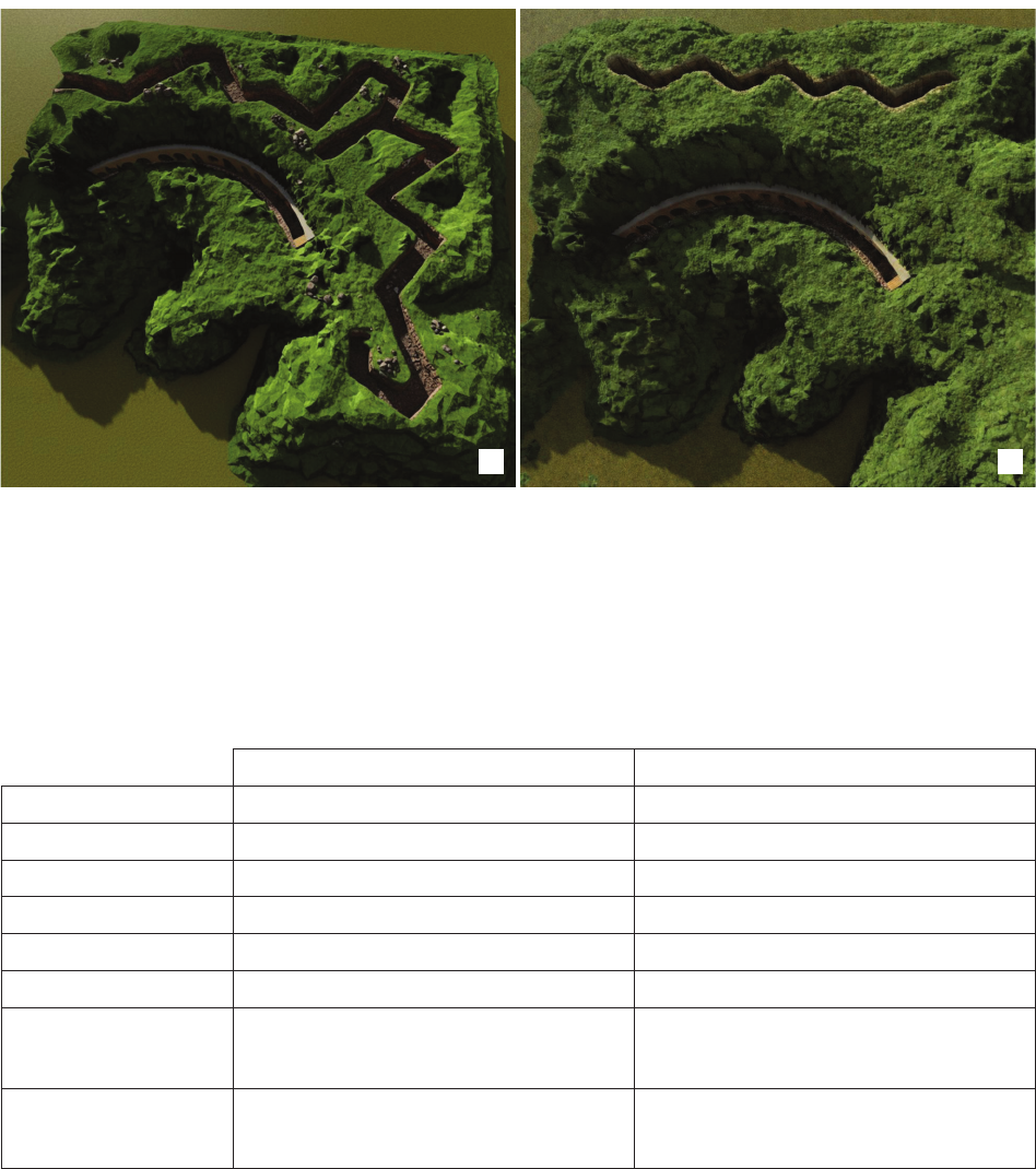
The rst variant (Fig. 5a) involves the construction of
a long trench with a zigzagging and highly winding course,
situated in the upper part of the site, in the immediate vi-
cinity of the gunpowder laboratory, on the eastern side.
The trench’s course makes use of the natural topography.
Its length allows for the creation of a continuous line of
defence and the establishment of a front line, as well as the
deployment of several ring positions. The trench can also
serve a communication function, as it allows the garrison to
move relatively safely within the trench. It is also partially
extended closer to the gunpowder laboratory building, thus
providing better access to its rooms. The sharply zigzag-
ging shape of the trench limits the possibility of anking
re and reduces the eects of a shock wave (Doyle 2019).
This variant requires a greater amount of earthworks.
The second variant (Fig. 5b) involves constructing
a trench
that is also zigzag-shaped, but with a less winding
course. It is also situated in the upper part of the site, but
is shorter in length. The limited length of the fortication
means it serves a more combat-oriented function and can
act as an observation and cover position. The smaller num-
ber of bends and the shorter length facilitate quicker con-
struction and reduce the scope of earthworks. This makes
this variant a more viable option where construction time
is limited. At the same time, its defensive potential is more
limited compared with the rst variant.
A comparison of the options highlights, above all, the dif-
fering nature of the proposed solutions and the associated
design trade-os. The rst option oers greater potential in
terms of territorial defence and transport functionality, which
is its main advantage in the context of protracted hostilities.
At the same time, this solution involves a much greater need
for terrain modication and more demanding construction
requirements. Option two is characterised by a shorter con-
struction time, which may be its key advantage in situations
requiring the immediate securing of the area. However, the
reduced length and simpler layout of the fortication result
in a lower level of protection and reduced functionality. This
comparison shows that the proposed variants do not compete
directly with one another, but can be utilised in various situ-
ations where the priorities may be either to maximise defen-
sive potential or to minimise implementation time and inter-
ference with the terrain. This approach conrms the validity
of applying variant analysis as early as the conceptual stage.
The choice of the immediate vicinity of the gunpowder
laboratory as the area for variant analysis was dictated by
three methodological considerations. Firstly, a coherent,
high-resolution point cloud was available for this area. This
enabled reliable modelling of the terrain.
Secondly, the aim of the study was not to identify the tac-
tically optimal location for fortications. Such an aim would
have required an analysis of an area extending well beyond
Boyen Fortress. It would also have required consideration
of military doctrine and current defence service guidelines.
Instead, the aim was to demonstrate a methodology for ex-
ploring variants of site interventions within a BIM environ-
ment, using a specic, well-documented case study.
Thirdly, the analysis in the immediate vicinity of the his-
toric monument highlights a signicant conservation con-
straint. None of the proposed variants is recommended for
BIMinassessingthesuitabilityofhistoricforticationsformilitarypurposes 85
in clear conict with the preserved historic earthworks of
Boyen’s Fortress. This applies to the cross-walls, parapets
and the structure of the moat. Carrying out such works in
the current condition of the site would lead to irreversible
damage to the historic fabric. Deeper earthworks could also
endanger the underground, masonry section of the labora-
tory. From a conservation perspective, none of the options
presented can be recommended for implementation. This
would require a prior comprehensive Heritage Impact As-
sessment (HIA). The consent of the relevant heritage con-
servation ocer would also be required.
It is precisely this observation that constitutes one of the
main conclusions of this study. Variant analysis within a BIM
implementation given the current condition of the site. This
is due to the risk of damage to the preserved earthworks,
such as cross-walls and parapets, as well as the under-
ground section of the laboratory. The analysis of alternative
options is therefore illustrative in nature. It demonstrates
how a BIM-based analysis of alternative options enables
the identication of conicts with the historic fabric even
before a decision is made on site.
Discussion
The proposed options for the location of the trenches
in the immediate vicinity of the gunpowder laboratory are
a b
Fig. 5. A simulation of a trench created using: a) Nano Banana Pro – variant 1 (source: Nano Banana Pro – Gemini 2.5 Flash Image; Google),
b) ChatGPT – variant 2 (source: ChatGPT; OpenAI)
Il. 5. Symulacja okopu utworzona za pomocą: a) Nano Banana Pro – wariant 1 (źródło: Nano Banana Pro – Gemini 2.5 Flash Image; Google),
b) ChatGPT – wariant 2 (źródło: ChatGPT; OpenAI)
Variant 1 (Fig. 5a) Variant 2 (Fig. 5b)
Location northern and eastern parts of the site northern part of the site
Length long short
Course very winding, zigzagging zigzagging
Primary function defensive and communication observation and combat
Defensive potential high medium
Extent of earthworks greater smaller
Design assumptions
a description incorporating a long, zigzagging trench
adapted to the natural terrain, providing cover for positions
and enabling communication along the line of defence
a description involving a short, zigzagging trench
with a simplified layout, designed for rapid construction
and to serve as an observation and cover post
Compliance with Ministry of
the Interior and Administration
Regulation 2025
prompt specifications in accordance with
the dimensions (height 150–220 cm, width 80–120 cm);
illustrative representation
the design of the prompt complies with the dimensions
(height 150–220 cm, width 80–120 cm);
illustrative representation
Table 1. Evaluation criteria and comparison of conceptual variants of trenches generated using AI tools (elaborated by K. Zelkowska, M. Żach)
Tabela 1. Kryteria oceny i porównanie koncepcyjnych wariantów okopów wygenerowanych z wykorzystaniem narzędzi AI
(oprac. K. Zelkowska, M. Żach)
86 Andrzej Szymon Borkowski, Klaudia Zelkowska, Małgorzata Żach
in the event of a building’s destruction as a result of mil-
itary action or other causes, a model created beforehand
can serve as digital documentation to support the recon-
struction or repair process. HBIM demonstrates just how
important it is to have models of historic build
ings. Tradi-
tional methods of documenting historic buildings, such as
technical drawings, textual descriptions or photographs, are
often incomplete, scattered and insucient for conducting
comprehensive spatial analyses and making conservation
decisions (Penjor et al. 2024). Furthermore, it is worth not-
ing that, in the case of reconstruc
tion, it is much easier to
use a model previously created using a point cloud whilst
the building still stands, rather
than using individual pho-
tographs, from which a model is only created after a great
deal of work. It should be noted, however, that the model
developed for the Boyen Fortress gunpowder laboratory is
simplied in nature and does not constitute a full HBIM
model. The data was obtained mainly from aerial views,
which limits the accuracy of the representation of the build-
ing’s architectural and structural details. To develop a mod-
el with a higher level of detail, it would be necessary to
carry out a scan from ground level and a detailed survey of
the site. At the same time, the level of detail adopted proved
sucient to achieve the aim of the study, which was to ex-
plore dierent options and visualise the potential location
of the trenches.
Signicant tool-related limitations were identied during
the implementation of the project activities. Autodesk Revit,
as a parametric environment, is not fully suited to modelling
and editing terrain with complex topography and a large
number of points. Attempts to adjust the terrain levelling
proved particularly problematic, placing a signicant com-
putational load on the programme and, con sequently, lead-
ing to instability and crashes. In practice, this made it di-
cult to make any corrections to the terrain model. A solution
in such a situation would be to use other tools dedicated to
working with terrain models, and to import simplied ge-
ometry into the BIM environment in order to improve the
quality of the work. However, in the work carried out in
this article, this approach was not adopted, which limited
the ability to model and modify visualisations of trench
variants. Consequently, a key element was the use of arti-
cial intelligence-based tools to visualise trench variants. The
use of AI enabled the rapid presentation of spatial concepts
without the need to manually model all variants, which sig-
nicantly reduced the time required for the work. These vi-
sualisations can be regarded as a stage preceding the actual
design process, allowing the selection of the most rational
solution for further, manual development within a BIM en-
vironment. It should be emphasised, however, that AI-gen-
erated visualisations are for illustrative purposes only and
do not constitute a professional simulation. Solutions based
on generative articial intelligence are therefore used in the
early stages of the design process, primarily at the concep-
tual stage, where they enable the rapid generation of new
ideas, thereby signicantly increasing the eciency of de-
sign work (Li et al. 2025). Nevertheless, the rapid devel-
opment of articial intelligence suggests that, in the future,
these tools may oer an increasingly high level of accuracy
and become a signicant aid in the design process.
environment allows for the early identication of conicts
with the historic fabric. The digital model reveals spatial
conicts which, at the preliminary concept stage, would not
be obvious without visualisation. In this way, BIM becomes
a tool for protecting heritage from hasty planning deci-
sions. It is not, however, a tool that facilitates intervention.
From the perspective of conservation practice, it would
be most appropriate to locate any contemporary fortica-
tions outside the boundaries of the historic complex. Vari-
ation analysis in BIM enables a rapid comparison of such
alternatives outside the fortress with options within it. This
provides conservation arguments in favour of the former
solution.
The use of the full BIM suite and AI tools to design
a single, limited section of earthworks could, in isolation,
be disproportionate to the scale of the problem. In this pa-
per, however, the scope of the analysis was determined by
its demonstrative function. The selected site and the limited
length of the variants allowed for a clear presentation of the
methodology within a single academic article.
The true value of the proposed approach only becomes
ap parent when applied on a larger scale. This applies to ana-
lyses covering entire fortication complexes, networks of
critical infrastructure, or cultural heritage portfolios. In such
cases, a unied methodology enables a systematic com-
parison of variants across multiple sites. In this sense, the
gunpowder laboratory at Boyen Fortress serves as a proof-
of-concept in this work, rather than the main focus of the
project investment.
BIM models of fortications, whether simplied or more
detailed, can serve as a valuable tool to support spatial anal-
yses, the evaluation of alternatives and the assessment of
potential scenarios. It is particularly advantageous to pre-
pare such models and analyses at a time when there is no
immediate threat and when it is possible to collect and anal-
yse data without time pressure. It is worth emphasising that
creating a simplied BIM model, based on a point cloud,
does not require highly advanced HBIM expertise. Nowa-
days, spatial data does not have to be acquired exclusively
using expensive platforms, and the equipment used for data
collection can often be signicantly cheaper (commercial
drones or even a mobile phone and a suitable app). This
lowers the technological barrier to entry and enables organ-
isations with limited technical resources to carry out such
work. It should be noted, however, that the equipment used
aects the accuracy and reliability of subsequent analyses,
which should be taken into account when interpreting the
results. Carrying out scans and creating models during pe-
riods when there is no threat brings many benets. The n-
ished model can be immediately used to carry out concep-
tual analyses, explore alternatives, and develop action plans
which, in the event of a conict, could be implemented
much more quickly and eciently. From a national security
perspective, an unquestionable advantage of using a BIM
model is precisely the ability to carry out scenario analyses,
compare options for eld interventions, assess their spa-
tial consequences, identify potential problems even before
eld operations commence, and conduct preliminary risk
predictions. BIM can thus serve as a tool to support de-
cision-making processes in crisis situations. Furthermore,
BIMinassessingthesuitabilityofhistoricforticationsformilitarypurposes 87
Conclusions
The topic addressed in this article – the use of BIM to
assess and prepare historic fortications formerly used for
military purposes with a view to conducting variant analy-
ses of defence simulations – is rarely discussed in contem-
porary specialist literature or public debate, despite the fact
that it combines two important issues: heritage conserva-
tion and national security. Given the current geopolitical
situation, greater attention should be paid to the issues of
national security and preparedness, including the prepara-
tion of historic sites for potential defence in the event of
an armed conict. It is worth considering the creation of
digital models of sites during peacetime as a preventative
measure, which can be used in a crisis situation for rapid
scenario analysis and the evaluation of alternative concepts
without the need to commence survey work on a given site
under pressure and logistical constraints. In this context,
BIM serves as a useful tool for supporting variant planning
and spatial risk assessment, as it enables us to organise key
information regarding the geometry of a structure and its
surroundings. It would therefore be worth considering the
creation, in peacetime, of a database of BIM models of crit
-
ical infrastructure and historic buildings, which would be
regularly updated as part of heritage protection and crisis
management. Such a database would enhance the state’s
preparedness in the event of a conict and would also sup-
port conservation objectives. It should be noted that the
creation of such a database should be preceded by the de-
nition of clear criteria and standards, so that the models it
contains are as standardised as possible and ready for im-
mediate use without the need for corrections, which would
facilitate and accelerate work on the collected models.
Translated by
AndrzejSzymonBorkowski
References
Borkowski, Andrzej Szymon, and Alicja Kubrat. “Integration of Laser
Scanning, Digital Photogrammetry and BIM Technology: A Re-
view and Case Studies.” Eng 5, no. 4 (2024): 2395–409. https://doi.
org/10.3390/eng5040125.
Borkowski, Andrzej Szymon, and Patrycja Olszewska. “Model HBIM jako
cyfrowy bliźniak na przykładzie Chaty z Gawrych w Skansenie Kur-
piowskim w Nowogrodzie.” WiadomościKonserwatorskie –Journal
of Heritage Conservation 77 (2024): 137–48. https://doi.org/
10.48234/
WK77GAWRYCH.
Dore, Conor, and Maurice Murphy. “Current State of the Art Histor-
ic Building Information Modelling.” International Archives of the
Photogrammetry, RemoteSensingandSpatialInformationSciences
XLII-2/W5 (2017): 185–92. https://doi.org/10.5194/isprs-archives-
XLII-2-W5-185-2017.
Doyle, Peter. “Trench Construction and Engineering Geology on the West-
ern Front, 1914–18.” In MilitaryAspects ofGeology: Fortication,
Excavation and Terrain Evaluation, edited by Edward P.F. Rose, Judy
Ehlen and Ursula L. Lawrence. Geological Society of London, 2019.
https://doi.org/10.1144/SP473.6.
Franczak, Paweł, and Witold Jucha. “Odtworzenie przebiegu linii oko-
pów z II wojny światowej (OKH Stellung b1) w Paśmie Jałowiec-
kim i Grupie Mędralowej na podstawie numerycznego modelu terenu
z danych LiDAR i badań terenowych.” Acta Universitatis Lodzien-
sis. FoliaGeographica Socio-Oeconomica, no. 22 (2015): 87–108.
https://doi.org/10.18778/1508-1117.22.05.
Krahel, Sebastian. “Twierdza Boyen (Giżycko) – fortykacja jako atrakcja
turystyczna.” PraceiStudiaGeograczne 32 (2003): 99–115.
Li, Chengyuan, Tianyu Zhang, Xusheng Du, Ye Zhang, and Haoran Xie.
“Generative AI Models for Dierent Steps in Architectural Design:
A Literature Review.” FrontiersofArchitecturalResearch 14, no. 3
(2025): 759–83. https://doi.org/10.1016/j.foar.2024.10.001.
Liu, Xiaoyu, Xugang Lian, Wenfu Yang, Fan Wang, Yu Han, and Ya-
fei Zhang. “Accuracy Assessment of a UAV Direct Georeferencing
Method and Impact of the Conguration of Ground Control Points.”
Drones 6, no. 2 (2022): 30. https://doi.org/10.3390/drones6020030.
López, Facundo José, Pedro M. Lerones, José Llamas, Jaime Gómez-
García-Bermejo, and Eduardo Zalama. “A Review of Heritage
Build ing Information Modeling (H-BIM).” Multimodal Technolo-
gies and Interaction 2, no. 2 (2018): 21. https://doi.org/10.3390/
mti2020021.
Murphy, Maurice, Eugene McGovern, and Sara Pavia. “Historic Building
Information Modelling (HBIM).” Structural Survey 27, no. 4 (2009):
311–27. https://doi.org/10.1108/02630800910985108.
Penjor, Tshering, Saeed Banihashemi, Aso Hajirasouli, and Hamed Golzad.
“Heritage Building Information Modeling (HBIM) for Heritage Con-
servation: Framework of Challenges, Gaps, and Existing Limitations
of HBIM.” DigitalApplicationsinArchaeologyandCulturalHeritage
35 (2024): e00366. https://doi.org/10.1016/j.daach.2024.e00366.
“Rozporządzenie Ministra Spraw Wewnętrznych i Administracji z dnia 27
czerwca 2025 r. w sprawie budowli ochronnych i ukryć.” Dz.U. 2025
poz. 932. Published July 14, 2025. Accessed November 17, 2025, at
https://isap.sejm.gov.pl/isap.nsf/DocDetails.xsp?id=WDU20250000932.
Twierdza Boyen Giżycko. “14. Laboratorium Prochowe.” Published n.d.
Accessed November 7, 2025, at https://przewodniktwierdza.gizycko.
pl/lista-obiektow/14-laboratorium-prochowe.
“Twierdza Włocławek. Okopy – najpowszechniejsze umocnienia ‘twier-
dzy’.” Published 2025. Accessed November 17, 2025, at https://www.
twierdzawloclawek.pl/elementor-246/.
Streszczenie
BIM w ocenie przydatności zabytkowych fortykacji do celów militarnych
na przykładzie laboratorium prochowego Twierdzy Boyen w Giżycku
Building Information Modeling (BIM) znajduje coraz szersze zastosowanie w dokumentowaniu, analizie oraz ochronie obiektów zabytkowych,
umożliwiając tworzenie cyfrowych modeli, które następnie mogą być wykorzystywane jako podstawa do różnorodnych analiz przestrzennych. W kon-
tekście obiektów fortykacyjnych szczególne znaczenie ma możliwość wykorzystania takich modeli do oceny ich potencjalnej przydatności w scenariu-
szach obronnych. W artykule na przykładzie laboratorium prochowego Twierdzy Boyen w Giżycku (Polska) przedstawiono zastosowanie uproszczone-
go modelu BIM jako narzędzia wspierającego analizę powiązań obiektu z otaczającym terenem oraz koncepcyjne wariantowanie ingerencji terenowych,
88 Andrzej Szymon Borkowski, Klaudia Zelkowska, Małgorzata Żach
takich jak okopy. Cyfrowy model obiektu i jego otoczenia, uzupełniony o analizy przestrzenne, umożliwił ocenę uwarunkowań przestrzennych, identy-
kację potencjalnych kierunków zagrożeń oraz porównanie możliwych rozwiązań lokalizacji i wyglądu umocnień ziemnych. Ze względu na ograniczenia
środowiska BIM w zakresie modelowania złożonej geometrii terenu na etapie koncepcyjnym wykorzystano narzędzia generatywnej sztucznej inteli-
gencji do wizualizacji wariantów potencjalnych umocnień ziemnych. Uzyskane rezultaty wskazują, że nawet uproszczone modele BIM mogą stanowić
użyteczną podstawę do analiz wariantowych oraz dokumentacji obiektów zabytkowych. Jednocześnie narzędzia oparte na sztucznej inteligencji znajdują
zastosowanie przede wszystkim na wczesnych etapach prac koncepcyjnych, wspierając proces podejmowania decyzji poprzez szybkie przedstawienie
możliwych rozwiązań, przy zachowaniu ich poglądowego charakteru.
Słowa kluczowe: BIM, Twierdza Boyen, chmura punktów, okop, sztuczna inteligencja, laboratorium prochowe