2011
Nr 1(28)
Historical outline
was built with the use of stones and bricks as a single-nave
church on the layout of a Latin cross closed with a polygo-
nal chancel. The front facade, pedestals, the rose window
above the entrance, cornices, window frames, traceries
and some details of interior decoration were built of stone
(sandstone) and they demonstrate excellent workmanship.
The external walls were built of bricks with charac-
teristic buttresses and two towers with octangular spires
and a decorative viewing terrace between them. The nave
is covered with a pointed ribbed groin vaulting with lu-
nettes. The church has pointed windows with neo-Gothic
traceries and one of its characteristic features is a stone
attic with an ogival motif on arcade cornice.
Above the nave there is a gable roof with a gradient of
18° and a polygonal (pentagonal) one above the chancel.
When looked at from the man’s eyes’ level the roof is not
visible as it is concealed by the attic. The roof framing is
made from different species of conifers (spruce, pine and
larch) with the original strutting beam structure with full
roof boarding for copper sheets [1, 2].
Małgorzata Mełges*, Hubert Mełges**
Research method in recognizing the causes
and level of destruction of the roof construction
in the neo-Gothic 19
th
century St. Martin’s Church in Krzeszowice
designed by Karol Fryderyk Schinkel
The St. Martin’s neo-Gothic parish church in Krzes-
zowice (Little Poland Province) has been preserved in an
unchanged condition until today. The church was built
thanks to the artistic patronage of Count Potocki – the
owner of Krzeszowice holdings who decided to build the
church and very carefully selected the best design concep-
tion. The first drafts of the design of the church were made
by two excellent Parisian architects Percier and Fonteine.
The final design, however, which was the basis for build-
ing the church was made by a famous architect from Berlin
Karl Schinkel. In 1832, the design was approved and the
construction of the church without its interiors was com-
pleted in 1844. It was another architect from Berlin and his
student Wilhelm Hofbauer who was the direct builder and
executed Schinkel’s vision. The works, including the fur-
nishing of the interiors, were completed in 1872. Over the
period of about 140 years the church has been used with-
out any problems despite the fact that since its erection the
number of people living in Krzeszowice has grown a few
times. The church is on the permanent conservation list. It
Current condition of the church
The general condition of the church building, with the
exception of the roof framing, is good (assuming the nec-
essary maintenance works are conducted). The result of
different destructive exposure to which the roof framing
has been subjected over about 150 years is a serious tech-
nical and biological decapitalization. In order to deter-
mine the condition and degree as well as the reasons of its
destruction a number of special tests have been conducted
and a number of expert opinions have been made.
*
Cracow University of Technology, Faculty of Architecture, Institute
of Construction Design.
**
Cracow University of Technology, Faculty of Architecture, Institute
of Urban Planning.
266 Małgorzata Mełges, Hubert Mełges
Program of tests
The basic criterion of evaluation was the necessity to
make a survey of the roof framing indicating its decapital-
ized fragments. The survey was the basis of further works
such as statistical and strength analysis aimed at determin-
ing the safety of construction elements of the roof fram-
ing with conclusions and recommendations regarding the
necessity to save the building from unpredictable conse-
quences of such loads as e.g. of snow, ice, wind, etc. In or-
der to get the full picture of the damage of the roof framing
it was necessary to conduct phytopathological, entomologi-
cal and mycological tests [3].
After conducting expert evaluations and thorough analy-
sis it was possible to determine the scope of threats and their
origin. This was the basis of conclusions as to the method
and effectiveness of corrective actions regarding the histori-
cal roof framing. All tests and expert evaluations evidently
indicated a very serious technical destruction and extensive
damage of the biological loadbearing structure of the roof
framing. The wood samples which were taken for analysis
(phytopathological, entomological and mycological tests)
demonstrated a huge degradation caused by the destructive
activity of insects – mainly old-house borer, deathwatch and
wood-rotting fungus (Poria vaporaria). The condition of
damaged construction elements, sheathing and roofing in-
dicates that the loss of structural strength of those elements
exceeds 60% and they should be either repaired or replaced.
Otherwise and in the case of additional unpredictable expo-
sure to the elements the roof might collapse.
Selected examples of survey measurements
One of the characteristic features of historical sacred
buildings is their individualism. This is the surveying
method which was applied in the case of the St. Martin’s
church in Krzeszowice.
Firstly, new surveying methods should be mentioned.
They apply CAD, photogrammetry and laser scanning in
measuring historical and contemporary architecture, tech-
nical infrastructure and industrial installations. Engineer-
ing geodesy and photogrammetry have been employed for
years in performing comprehensive architectural surveys.
The measurements were taken with the use of a reflector-
less tacheometer (close range surface measurements of e.g.
walls), e.g. semi-metric camera to make ortophotoplans.
At present as a result of the digital technology develop-
ment new measuring devices have been developed such as
lasers and laser scanners, in particular with the use of 3D
measurement technique (vector file with refraction line-
sand a grid of points). These tools take measurements of
hundreds of thousands of points, recording the geometry
of large objects. Despite their great capabilities the new
measuring devices do not perfectly render the reality of
objects (e.g. the ‘edge sliding effect’ which ultimately gen-
erates a corrupt measurement). It is true that the use of new
photogrammetric technology in taking measurements in
connection with a laser scanner, visualizations and anima-
tions influence the duration and effectiveness of the meas-
urement work. When deciding to use the new generation
equipment, one should analyze the object and a possibility
to get with that equipment to the place of measurements.
Nowadays, the application of the above-mentioned meas-
uring methods is required. There are, however, situations,
especially in historical objects when making manual draw-
ings and measurements is more useful (especially in the
case of inaccessible and concealed places).
The method of performing the architectural survey of the roof framing
of the church in Krzeszowice
The nave and the pentagonal chancel are covered
with a pointed ribbed groin vaulting above which there
is a strutting roof framing system with a very unusual
construction. The shape of the vaulting and the location
of roof trusses in relation to it created a limited acces-
sibility of the place needed to take measurements with
the use of new generation equipment. Some places
needed for the inspection of the construction system as
well as to make drawings and measurements were practi-
cally inaccessible or at best one needed to crawl to get
there.
The unusual character of woodwork solutions as well
as geometry required a precise manual measurement.
In order to make a drawing of the roof framing of the
church the following were performed first: a detailed sur-
vey of the church floor plan at ground level, cross and
longitudinal sections with views of the church interior,
plan of the vault above which there is a roof framing,
cross sections of the roof framing with views of special
main trusses and plan of the fifth elevation that is of the
roof with gradient of planes and water drainage system.
The other type of performing a survey was photographic
documentation which resulted in the development of so
called research cards. The objective of this type of survey
was to precisely establish the location and type of con-
struction, details and degree of technical decapitalization.
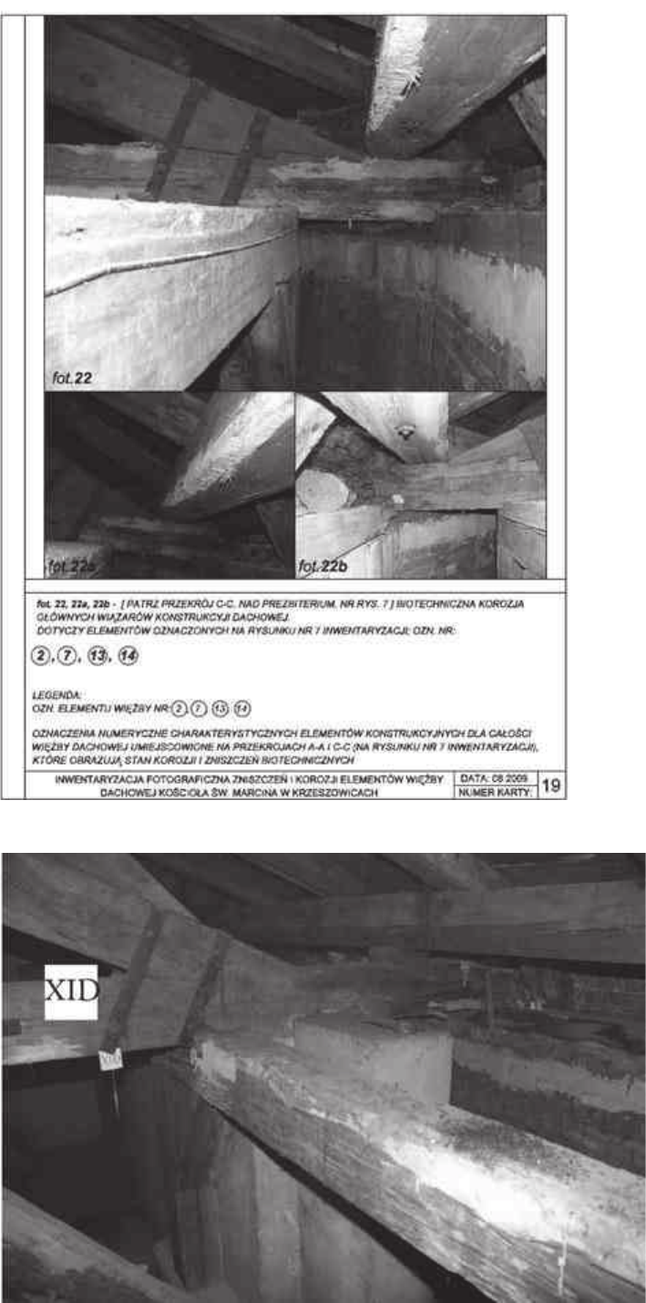
A specially developed method of assigning numbers to
construction elements (trusses and woodwork connec-
tions) corresponding to their specific location in the plan
and cross sections was applied in each research card. This
Research method in recognizing the causes and level of destruction of the roof construction in the neo-Gothic... 267
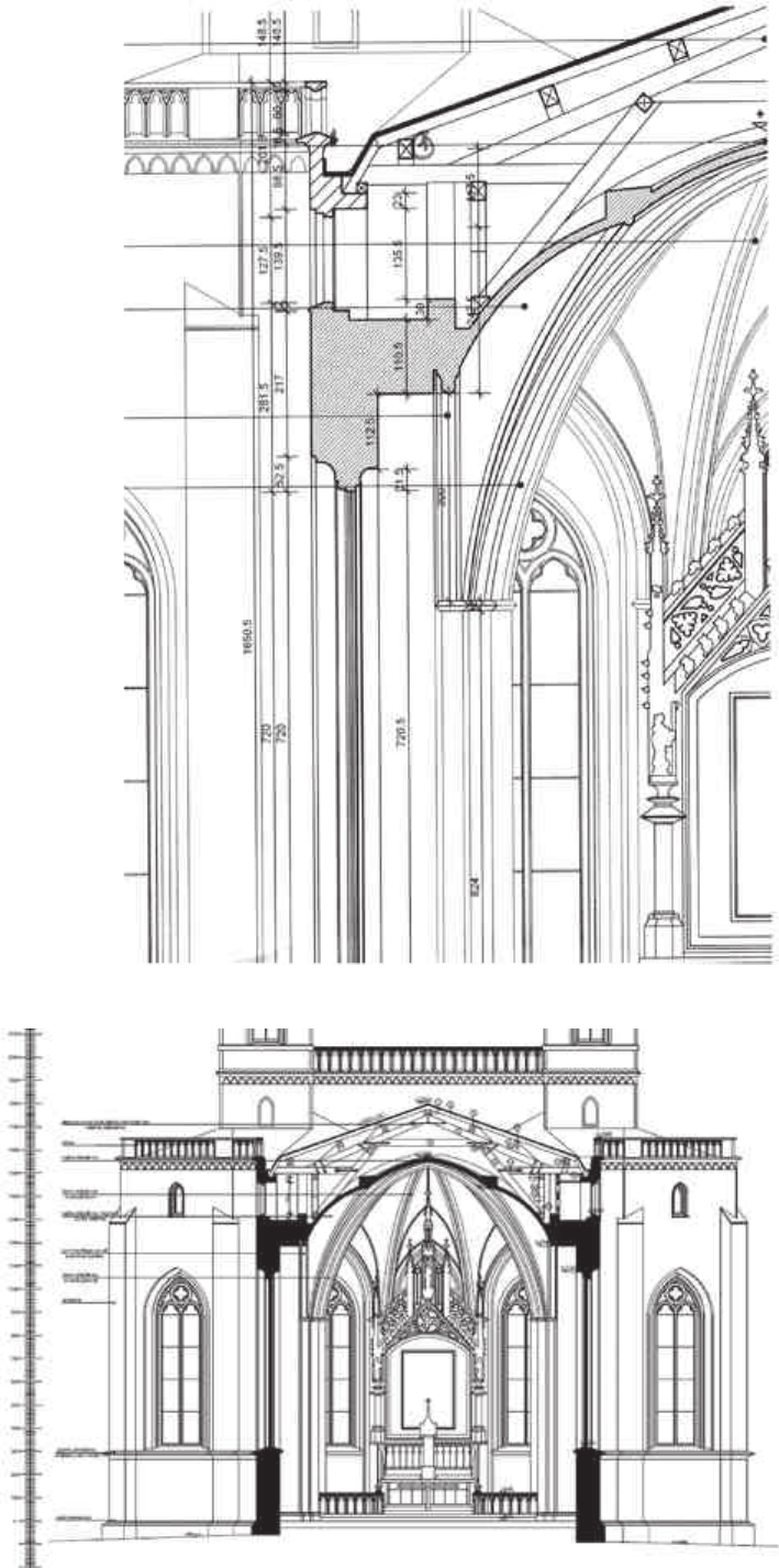
Fig. 1. Cross section of the nave of the church
with the view of one of the main trusses
Fig. 2. Initial plans
of the particular fragments
of the church in order to check
the accuracy of measurements
with the use of laser equipment
268 Małgorzata Mełges, Hubert Mełges
Fig. 3. Research Card
Fig. 4. Markings of various types
of main trusses and places
of destruction
Research method in recognizing the causes and level of destruction of the roof construction in the neo-Gothic... 269
method significantly facilitated the detection of damaged
places and their scope. Because of very special and unu-
sual joints and woodwork connections, all details required
a careful analysis, inspection and measurement from all
sides with the use of traditional manual technique. What
proved especially helpful in recognizing the complicat-
ed woodwork details was the free-hand sketches drawn
in perspective which helped to precisely reconstruct the
original roof framing. The complicated system of the
main trusses, which were applied in different variations,
required a precise determination of different gradients of
the roof planes above the nave and the chancel as well
as side chapels. The precisely performed survey was the
basis of the design of the whole roof framing replacement.
The bigger interior spaces which were not concealed were
measure with laser equipment; these measurements were
in special cases verified by manual measurements with
the use of measure tapes. The whole architectural survey
documentation was ultimately made with the use of com-
puter graphic in the following scales 1:50, 1:10 and 1:2.
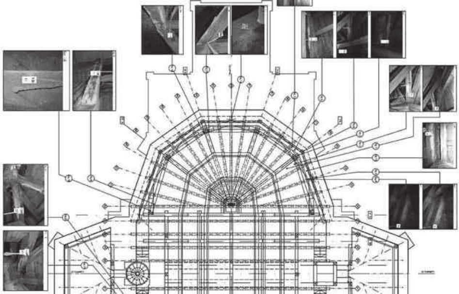
Color icons of pictures which presented appropriate plac-
es and their degree of destruction were placed on the basic
plans of the location of specific construction elements of
the roof framing.
Fig. 5. Fragment of roof truss projection with the accepted system of markings in relation to research cards
Conclusions
In conservation works in historical buildings, the basis
for the beginning of any work is the necessary detection
of different details in the scope of damage, repair or re-
placement of necessary elements, etc. The complete and
precisely performed survey is the basis of precise analysis
of different kinds of damage. An architectural survey is
primarily used as a basis for plotting the scale of dam-
age and different types of deformations on it. A good
graphic survey with a photographic survey and other
necessary tests should constitute a concise and compre-
hensive document which is the basis for the determi-
nation of the extent and percentage of damage as well
as for the selection of repair method and estimation of
costs.
References
[1] Baraniewski W., Projekty Karla Friedriecha Shinkla dla Krzeszowic,
Kwartalnik Architektury i Urbanistyki XXVII, 1982.
[2] Baraniewski W., Zespół rezydencjonalny w Krzeszowicach w XIX w.,
[in:] Dzieła czy kicze, Warszawa 1981.
[3] Mierzwa W., Rzonca A., Skanowanie powierzchni, jako nowa
metoda rejestracji i interpretacji szczegółów architektonicznych,
Archiwum Fotogrametrii, Kartografii i Teledetekcji, Vol. 13, Wrocław
2003.
270 Małgorzata Mełges, Hubert Mełges
Metoda badawcza w rozpoznawaniu przyczyn i stopnia zniszczenia konstrukcji dachowej
w zabytkowym neogotyckim XIX-wiecznym kościele św. Marcina w Krzeszowicach
autorstwa Karola Fryderyka Schinkla
W artykule przedstawiono zagadnienie wskazujące, że zabytkowe
budowle sakralne, których stan techniczny i estetyczny uległ dekapita-
lizacji, wymagają opracowania indywidualnego programu badawczego,
szczególnie w takich branżach, jak: architektoniczna, konstrukcyjna,
konserwatorska oraz charakterystycznych specjalistycznych ekspertyz.
Specyfiką zabytkowych obiektów sakralnych jest ich indywidualizm
wynikający z: okresu powstania (styl), miejsca usytuowania, konstrukcji,
budulca, kubatury i kontekstu klimatycznego. W pracach badawczych
należy przyjąć sprawdzone metody tradycyjne, nowoczesne oraz indy-
widualne metody dostosowane do indywidualnych charakterystycznych
cech budowli. Wyniki opracowania rozpoznawczego są istotną bazą do
przyjęcia prawidłowej logistyki przebiegu wymaganych prac budowla-
nych i konserwatorskich. Należy nadmienić, że obiekty, które zgłaszane
są o dofinansowanie z puli Ministerstwa Kultury i Dziedzictwa Narodo-
wego powinny być wnikliwie rozpoznane, w celu dokładnego określenia
kosztów inwestycji. Podjęte działania rozpoznawcze prezentowane są tu
na przykładzie neogotyckiego kościoła św. Marcina w Krzeszowicach
i dotyczą remontu kapitalnego wież i więźby dachowej
Key words: roof framing, decapitalization, reconstruction Słowa kluczowe: więźba dachowa, dekapitalizacja, odtworzenie