
2025
2(82)
Anna Steuer-Jurek*
Public greenery in Głogówek from the 19
th
century to the present day:
An analysis of historical and compositional changes
DOI: 10.37190/arc250208
Published in open access. CC BY NC ND license
Abstract
Public greenery is an essential part of a city’s or town’s urban layout. When it is designed in an informed manner during its various stages of de-
velopment, it becomes an artistically and functionally mature organism. In Głogówek, the rst systems of landscaped public greenery were observed
to be built in the 19
th
century. With the development of industry and the expansion of the town, new urban public gardens were created – they formed
a distinct system in the spatial layout. At present, the number of public greenery complexes has increased, but they no longer form an ordered and
interconnected system.
This paper discusses the public greenery system in Głogówek in dierent historical periods. This paper analyses the changes that took place be-
tween the 19
th
century and the present. This made it possible to formulate guidelines for revalorisation and dene directions for further development.
They aim to develop a system of urban gardens based on historical patterns and place-based identity.
Available archival material, including cartographic and iconographic material in particular, was used to characterise the public greenery system
in the city, as well as the transformations it underwent. The research also drew on literature on design guidelines, analogies or the wider context. The
contemporary state was determined by in-situ surveys.
After analysing the ndings, it can be assumed that public greenery designed in an informed manner is of great signicance – as it is one of the
expressions of a place’s identity that enables not only a link between historical and contemporary buildings, but also a better identication of the city
in the region.
Key words: public city gardens, city landscape, place-based identity, greenery systems, Silesia
Introduction
Głogówek is a small town
1
located on the Polish-Czech
border, in the southern part of the Opole Voivodeship. In
the past, it was dubbed “little Berlin”, and now, because
of its architecture, as a “pearl of Opolszczyzna” (Der kacz,
Szała and Szała 2009, 6, 7). The history of this town dates
back to the Middle Ages, where the rst mention of a vil-
lage under the name Glogov comes from documents of
Bishop Wawrzyniec from 1213–1217. The exact date of
when the town received its charter is unknown. Tadeusz
Chrzanowski (1977, 9, 10) states that this could proba-
* ORCID:
0009-0009-4440-9071. Faculty of Architecture, T. Koś-
ciusz ko Cracow University of Technology, Poland, e-mail: anna.steuer-jurek@
pk.edu.pl
1
The area of the town is 22.05 km
2
(Główny Urząd Statystyczny
2024).
bly have happened around 1264. In the Middle Ages, the
town’s centre was marked by a quadrilateral square with
a town hall in the middle. Streets with a grid-like layout
emerged from corners and intersected frontages. On the
north-west corner of the town was a Gothic fortress that
was later transformed into a Renaissance and Baroque
castle. The parish church of St Bartholomew was in turn
sited in the south-western part. A Franciscan monastery
was situated next to the castle to the south. A defensive
wall was erected around the entire complex, with three en-
trance gates and at least four towers. In addition, a moat
was dug on the outer side (Przybyłok 2014, 30–52). Sub-
urbs developed around the city – Winiary, Kozielskie,
Wodne and Oracze (Hauptstock 2016, 39–46). In the 17
th
century, Count George III Oppersdor turned the town
into a majorate. In the 18
th
cen tury, the market buildings,
originally wooden, were replaced with masonry develop-
ment that consisted of row tenements in the Baroque style
82 Anna Steuer-Jurek
(Kłuskiewicz, Grzegorczyk 2008, 20–22). The nal spatial
layout of the locality was formed at the turn of the 20
th
cen-
tury, when the city walls were demolished, the moat was
lled in and the former suburbs were incorporated into the
city. Modern infrastructure was developed to a considerable
extent: in the early 20
th
century, waterworks and a munici-
pal sewerage system and a new water tower were built, in-
dustry developed, and a railway connection was established
(Hauptstock 2016, 15–25; Chrza nowski 1977, 27–39).
Today, the historic town centre is protected by being list-
ed in the Opole Voivodeship register of monuments (Reg.
no.: R.184 of 10.06.1949). In addition, a number of singu-
lar buildings and green spaces are also listed in the register
of monuments and included in the municipal monument
records.
Stanisław Nicieja (Kłuskiewicz, Grzegorczyk 2008, 56)
described Głogówek as a town of towers and gardens. The
town owes this description to a picturesque view of its pan-
orama, with numerous towers steeped in greenery. This
was also inuenced by the nature of the former urban sub-
urbs, mainly engaged in horticulture (Wrobel 1993, 67–81;
Hauptstock 2016, 39–46).
With the development of the city, urban greenery also
played an important role in improving aesthetics, health,
and environmental and social conditions. According to
Marek Siewniak and Anna Mitkowska (1998, 295), urban
greenery essentially forms a certain system of composed
and interconnected spaces. The function and form of the
vegetation has varied at dierent times. Public greenery
has special signicance in this regard, and can be dened
as spaces that are accessible to the public without the ne-
cessity to meet additional, externally imposed conditions.
Such areas mainly include town and garden squares, parks,
urban gardens and ancillary green spaces along circulation
paths and roads. They are generally owned by the state or
local government (Mierzejewska 2011, 16, 17; Sutkowska
2006, 186). The development and establishment of public
greenery in Głogówek was evident from the 19
th
century
onwards, when the town signicantly expanded its territory
(Fig. 1). The course of successive wars at the beginning of
the 20
th
century brought a lot of damage, and gardens were
not exempt from this. Contemporary layouts of landscaped
greenery partially reference historic patterns, but new areas
for recreation are also created.
This paper discusses the public greenery system in Gło-
gówek in dierent historical periods. It characterises gar-
den complexes, their development and transformation in
the period between the 19
th
century and the present. Insight
into changes in garden layouts has allowed for a better un-
derstanding of the town’s spatial characteristics. As a result,
guidelines for revaluation and directions for further devel-
opment were formulated, taking into account not only the
identity of the site but also its historic urban fabric.
State of research, materials and methods
The research into the design of public greenery layouts
in Głogówek was divided into two main stages. During the
rst stage, the state of the art was determined and an archi-
val query was performed. Based on the literature, it was
found that public greenery in the area under study had not
been fully explored thus far. Hauptstock (2009, 63) makes
only cursory mention of urban gardens in his publication
on the town. However, there are many studies on the his-
tory and urban development of Głogówek (Chrzanowski
1977; Wrobel 2004; Hauptstock 2009). There are also
items devoted to individual buildings, such as the parish
church (Legendziewicz 2021, 47–64). Nevertheless, pub-
lic greenery, both as an element of the urban layout and
its individual components, has not yet been the subject of
detailed analysis. The researchers focused only on the city
park – they described its history, touched on contemporary
wildlife and ecological issues (Romanowska 2009, 46–57).
Attention has also been paid to denominational cemeteries,
i.e., characteristic green areas that are memorials (Steuer-
Jurek 2019, 133–144).
The archive queries yielded publications and sources on
the history and urban transformation of the town (Schnur -
pfeil 1860; Kosian 1931). In addition, articles from lo-
cal
pe riodicals (Oberglogauer Stadtblatt 1905, 1906, 1929)
which reported, among other things, on the changes that
had taken place in landscaped greenery. In addition, records
commissioned by heritage conservation services were used
(Próchnicka, Czyżowski 1987). The research also drew on
literature on design guidelines, analogies or the wider con-
text (Majdecki 2008; Jäger 1877; Koch 1914; Roz ma ry-
nowska 2017).
Cartographic and iconographic material was also ac-
quired. The main focus was on maps from the 19
th
and
20
th
centuries (Plan Głogówka z 1811 r., sygn. RO IX/19;
Urmesstischblatt 1825, sygn. Kart. N 729; Messtischblatt
1883; 1913; 1940). This made it possible to identify the
changes in the layout of the entire town. Archival postcards
(a set collected in the study by Kłuskiewicz, Grzegorczyk
2008) and numerous period photographs (Kłuskiewicz
2018) were also extremely helpful. On the basis of these,
compositions and garden interiors were identied, as were
plant species and garden features.
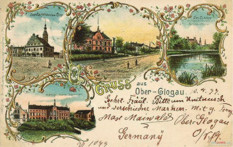
Fig. 1. Głogówek – postcard from the late 19
th
century
showing the market square, the square in front of the post office,
the castle park, and the square in front of teachers’ seminar
(source: Wojewódzka Biblioteka Publiczna im. E. Smołki w Opolu)
Il. 1. Głogówek – pocztówka z końca XIX w. przedstawiająca rynek,
plac przed pocztą, park zamkowy,
plac przed seminarium nauczycielskim
(źródło: Wojewódzka Biblioteka Publiczna im. E. Smołki w Opolu)
PublicgreeneryinGłogówekfromthe19
th
centurytothepresentday:Ananalysisofhistoricalandcompositionalchanges 83
Unfortunately there is a lack of publications on the con-
tem porary state and layout of public greenery in Gło gów ek.
Although there are documents dedicated to the nature of the
city (Program Ochrony Środowiska… 2021) the system of
urban gardens is not described in them in any way. There
are also no conservation guidelines for the revalorisation of
greenery and no directions for its development as an ele-
ment of the town’s historic layout have been outlined.
The second stage of the research consisted of numerous
research trips to the area. They identied the current ur-
ban conditions and assessed the state of preservation of the
previous greenery systems. Contemporary public gardens
were also surveyed. The observations also made it possi-
ble to identify development trends in both old and new ar-
eas of landscaped greenery. This formed the basis for the
formulation of general guidelines for the revalorisation of
greenery and outlining directions for the development
of landscaped greenery systems.
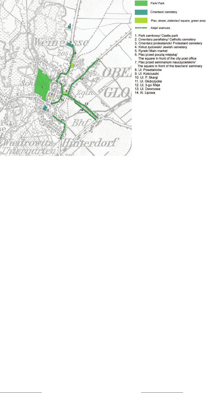
Public greenery in Głogówek in the 19
th
century
The 19
th
century saw the large-scale development of
ur ban
garden complexes. Increasing attention was paid to
beautifying cities by creating green spaces, garden squares,
city parks and plantings along roads (Jäger 1877, 616). The
garden section exerted a strong inuence on the shape and
development of cities – it created a consciously shaped sys-
tem of green areas, often linked by sequences of avenues
(Majdecki 2008, 312). Evidence of similar trends can also
be observed in Głogówek, where public greenery began to
develop signicantly from the 19
th
century onwards.
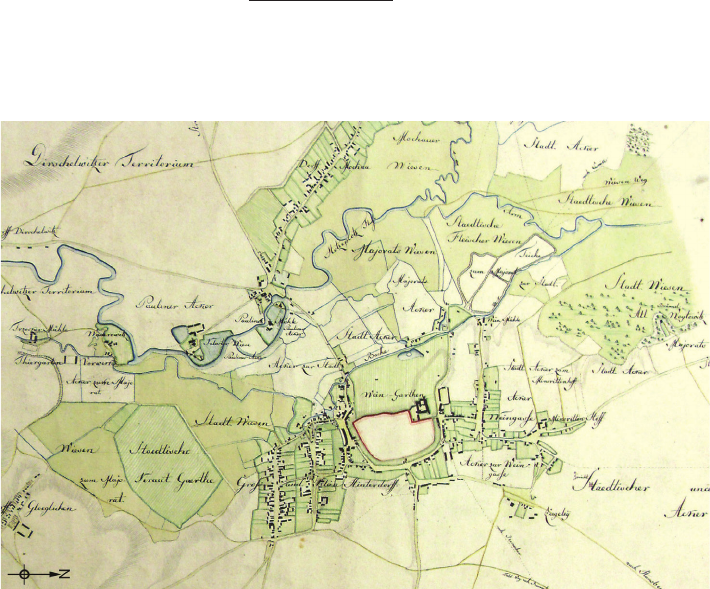
The rst account from which the system of urban gar-
dens in the area in question can be read is from a plan of
1811 (Plan Głogówka z 1811 r., sygn. RO IX/19). In it, one
can see the green belt that was created on the eastern side
of the town, where the defensive walls had previously been
located (Fig. 2). This is similarly depicted on the Urmess-
tischblatt 1825 (syg. Kart. N 729). Although this layout is
clearly marked on the map, no source provides detailed
information on it. Schnurpfeil (1860, 4) only wrote that
there had been orchards on the site of the former moat and
city walls. Festschriftzur 700-JahrfeierderStadt Ober-
glogau (Strecke 1925, 21) indicated instead the existence
of gardens between the city walls, which was mainly re-
lated to defensive aspects. Numerous panoramas from the
late 18
th
and early 19
th
centuries show the town surrounded
by tall trees, which may conrm the existence of a green-
ery system in the area. It is worth noting, however, that the
establishment of urban parks on the sites of former defen-
sive walls was common in Europe (e.g., Krakow, Vienna,
Brzeg). As cities grew and became larger, fortications
lost their signicance and were replaced by public parks.
It is therefore possible that there were ornamental or fruit
tree plantings in this area as well. Jäger (1877, 620–622)
emphasised the importance of preserving undeveloped
land to create urban gardens. He pointed out that this was
important for both the urban structure and the community.
Often – unfortunately – such spaces were used for further
development instead of for the expansion of public parks.
A greenery complex of this type also disappeared in
Głogówek in the late 19
th
century, and was replaced by
development. The urban layout, however, began to expand
towards the suburbs. New areas of public greenery were
created – they formed a distinct system, whose elements
can be divided into four categories: parks, squares and gar-
den squares, cemetery greenery, avenues and promenades
(Fig. 3). During this period, landscape architect (German:
Landschaftsgärtner) Oskar Janoroschke, owner of a plant
nursery, was active in the town. He was involved in both
conservation work and green space design
2
.
The castle park was one of the most striking features of
the layout. Like many other royal or court parks in Europe
2
Janoroschke published his theoretical work on Silesian parks and
contributed to journals on garden-related topics, including dieGarten-
kunst and MöllersDeutscheGärtner-Zeitung.
Fig. 2. Plan of Głogówek
from 1811 with gardens
created on the site
of the former town walls
(source: Archiwum Państwowe
w Opolu, sygn. RO IX/19)
Il. 2. Plan Głogówka z 1811 r.
z ogrodami powstałymi
w miejscu dawnych
murów miejskich
(źródło: Archiwum Państwowe
w Opolu, sygn. RO IX/19)
84 Anna Steuer-Jurek
A mesh fence was erected around it. At the end of the 19
th
century, the fence was removed and the fruit trees were
replaced by common chestnut trees and owerbeds were
created. The compositional layout was marked by a wide,
straight avenue branching o in the southern section.
Benches were placed along the path.
The third type of green space is denominational cem-
eteries – Catholic, Jewish and Protestant
4
. According to
Jäger (1877, 628–632), this type of area, due to its gar-
den-like character, was a frequent place where the town’s
residents took strolls. It was therefore necessary to intro-
duce a planned and well-thought-out layout on their site.
The parish cemetery, probably dating from the 17
th
cen-
tury (Paraa pw. św. Bartłomieja… 2024), as it covered
a considerable area and was located on a hill, stood out in
the urban layout. At the same time, due to its topography,
it was an attractive walking spot from which to observe
distant views, including the town’s skyline. In the 2
nd
half
of the 19
th
century, its area was signicantly increased
5
.
The compositional layout was based on avenues that in-
tersected at right angles. The main paths leading out of the
entrance gates were framed by lime trees. The remaining
denominational cemeteries were small in size and there-
fore did not have a clear layout of landscaped greenery
(Steuer-Jurek 2019, 133–144).
Along the town’s main streets, avenue plantings were
created connecting the individual gardens to each other.
Archival photographs (Kłuskiewicz 2018) and postcards
from the late 19
th
century (Kłuskiewicz, Grzegorczyk 2008)
show trees in their maturing stage. This indicates that these
4
Before the demolition of the city walls, all cemeteries were lo-
cated in the suburbs.
5
The assessment was made based on analysing the masp in (Urmess-
tischblatt 1825, sygn. Kart. N 729; Karte… 1886; Messtischblatt 1913).
(Majdecki 2008, 312–396), it was opened to the public. It
was famous throughout Silesia for its highly sophisticated
composition, topography and rare plant species. Although
the rst complex was built on the site in the 16
th
century,
the peak period of development dates to the 19
th
century
(Próchnicka, Czyżowski 1987). According to Kosian (1931,
149, 150), Duke von Pückler-Muskau gave advice on its
composition, structure and was responsible for the selec-
tion of plants. The park was open to the public until 8 pm
except on selected days of the year, and the entrance was
under guard (Schnurpfeil 1860, 161).
The other type of green spaces were town and garden
squares. The market square, which is the town’s most im-
portant square, was essentially all paved. Only on the south
side of the town hall has a row of trees with a circular
outline been planted. Postcards from the late 19
th
century
(Kłuskiewicz, Grzegorczyk 2008) show two more com-
posed squares in the town. The rst was located near the
town post oce. It had a free-form layout, with tall trees, as
well as ornamental owerbeds. Benches were placed along
the garden square’s paths. The whole was maintained in
accordance with the trends of the time, in a park-like fash-
ion. A postcard from 1899 shows that the area was enclosed
by a fence (Kłuskiewicz, Grzegorczyk 2008, 18). Equally
important for the residents was the square in front of the
teachers’ seminary in the former suburb of Winiary. In the
mid-19
th
century, the area merged with the teaching garden.
The front garden of the school was formal and surrounded
entirely by a hedge. The part that formed a garden square,
on the other hand, was most likely planted with fruit trees
3
.
3
It is likely that initially this part had been an orchard and an ex-
perimental garden where horticulture classes were held. Josef Schermuly
(1902, 142–145) wrote that the northern part of the complex belonging
to the seminary was maintained in a park-like style.
Fig. 3. Plan of Głogówek in
the 19
th
century with public
green areas marked
(elaborated by A. Steuer-Jurek
based on “Karte des Deutschen
Reiches” 1886)
Il. 3. Plan Głogówka w XIX w.
z zaznaczeniem terenów
zieleni publicznej
(oprac. A. Steuer-Jurek
na podstawie “Karte des Deutschen
Reiches” 1886)
PublicgreeneryinGłogówekfromthe19
th
centurytothepresentday:Ananalysisofhistoricalandcompositionalchanges 85
plantings were probably made at least in the 1
st
half of the
19
th
century. Towards the end of the 19
th
century, howev-
er, a new pedestrian promenade was created leading from
Przedmieście Kozielskie to the railway station, which was
then located on the outskirts of the town. It was planted
with small-leaved lime trees. It was the site of frequent
walks by the town’s residents.
20
th
-century changes
The introduction of landscaped greenery in the urban
layout continued in the early 20
th
century. In 1905, the Gar -
den Building Society (German: Gartenbauverain) was es-
tablished (Oberglogauer Stadtblatt 1905, no. 55). In 1906,
in turn, the mayor of Freyhube founded the City Beauti-
cation Society
6
(German: Verschönerungsverein) (Ober -
glo gauer Stadtblatt 1906, no. 49). These associations were
active until the 1930s. Their aim was to improve the vi-
sual amenity of the city by supplementing and restructur-
ing existing urban gardens and creating new public green
spaces (Fig. 4). Among others, harmonised and coherent
features were introduced (on photographs we can see iden-
tical wooden benches painted white). The square in front of
the post oce was remodelled (Fig. 5). Reviewing archival
6
Similar Societies also existed in many other towns in Silesia, in-
cluding Wrocław, Brzeg, Głogów, Oleśnica and Jawor (Rozmarynowska
2017, 137–141).
Fig. 4. Plan of Głogówek
in the 1
st
half of the 20
th
century
with public green areas marked
(elaborated by A. Steuer-Jurek
on the basis of
Messtischblatt 1940)
Il. 4. Plan Głogówka
w 1. poł. XX w. z oznaczeniem
terenów zieleni publicznej
(oprac. A. Steuer-Jurek
na podstawie
Messtischblatt 1940)
a b
Fig. 5. Square in front of the town post office in Głogówek:
a) at the beginning of the 20
th
century (source Wojewódzka Biblioteka Publiczna im. E. Smołki w Opolu),
b) contemporary state (photo by A. Steuer-Jurek, 2024)
Il. 5. Plac przed pocztą miejską w Głogówku:
a) na początku XX w. (źródło: Wojewódzka Biblioteka Publiczna im. E. Smołki w Opolu), b) współcześnie (fot. A. Steuer-Jurek, 2024)

86 Anna Steuer-Jurek
photographs, Kłuskiewicz (2018) notes that a circular square
was created in front of the building’s façade. The sophis-
ticatedly planned paths were replaced by straight, wide
avenues. Most of the trees have been removed and new,
smaller trees were planted, that did not obstruct the build-
ing
7
. A fountain was built in the western part. Such solu-
tions were in line with the trends and guidelines of the pe-
riod (Jäger 1877, 625, 626). The market square was also
changed. Instead of trees, a green area with four quarters
was created. A memorial to the fallen of the World War I was
placed in the centre. At the beginning, the plots were plant-
ed with grass and trees with a columnar outline (hornbeam
or beech), and pots with annual plants were placed. It is
reasonable to assume that this arrangement may have ob-
scured the Renaissance Town Hall
8
. It was later decided to
change plant composition to include globular maples and
ornamental perennials.
At the beginning of the 20
th
century, during the con-
struction of the municipal sewer system, most of the street
trees were cut down. The actions of the Societies led to
their restoration along major urban arterials. A wide pe-
des
trian promenade was also built leading from the railway
station to the former suburb of Oracze (now Dworcowa
Street). The entire area was anked by strips of lawn, plant-
ed
with lime trees and enhanced with park features
9
. There
were also plans to beautify the square between the water
tower and the gasworks (Oberglogauer Stadtsblatt 1906,
no. 136).
During the inter-war period, the City Beautication So-
ciety continued to develop public green spaces, pave streets
and maintain order. The focus was mainly on the outskirts
of the town
10
. During the period of urban densication and
industrial development, areas outside the urban boundaries
became particularly attractive to residents as they oered
distant views and contact with nature (Rozmarynowska
2017, 130). To the west of Głogówek, behind the castle
park, new strolling areas were also established. Existing
eld paths were decluttered and extended with a new cir-
culation system, and footbridges were built. The area was
equipped with benches and litter bins, and road signs were
installed to signal the hierarchy of the roads. Pasternik
7
Several postcards from the turn of the 20
th
century show four
palm-like trees along the façade of the post oce building. It is possi-
ble that these were container plants displayed in front of the building
from spring to autumn, or that exotic plants were originally planned to
be introduced there. In the end, however, it was decided to plant native
species.
8
Hugo Koch (1914, 569) wrote about the need to select suitable
tree species adapted to the surroundings.
9
From as early as the 19
th
century, many theorists and designers
have emphasised the important role of promenades and strolling paths
in the urban greenery system. In addition to the visual aspect of the city,
the creation and maintenance of such spaces built condence in public
authorities among society. On footpaths, it was recommended that pro-
viding shade was to be a priority and that resting places (benches, seats)
be organised. This meant that promenades were both functional and at-
tractive (Schmidlin 1863, 467–469).
10
The creation of new urban gardens and walking promenades
in the former suburbs and on the outskirts of the city was in line with
Koch’s indications (1914, 43). This architect recommended directing
pedestrian trac away from the city because of the promenades’ high
natural and recreational potential.
Street underwent modernisation and the park slopes were
planted with vegetation (Oberglogauer Stadt blatt 1929,
no.
86).
During this period, many new green spaces appeared in
the town. For example, a circular square was built in front
of the “Die Falle” restaurant with a solitary tree planted in
the centre. Other photographs from the years 1930–1940
show a green area in front of Grünn’s Villa (now the ad-
ministrative headquarters of ZPC Piast), in the middle of
which a square with a fountain was built. The whole was
framed by perimeter plantings of perennials and annuals.
There were also benches in the area.
After the World War II, some areas were destroyed and
many public green spaces deteriorated due to lack of care.
By resolution of the city council, the castle park was trans-
formed into a town park (Hauptstock 2009, 172). In 1945,
a cemetery for German soldiers killed in the World War II
was located in the northern part of the town, in the im-
mediate vicinity of the Evangelical cemetery. Its composi-
tional layout was very simple. The main axis was marked
by a rectilinear avenue of granite blocks. A lawn was cre-
ated to the north with individual trees and a eld altar. In
the southern section, an arrangement of simple, geometric
plots in a linear arrangement was created. A concrete cross
has been placed at the end of the main path.
Current state
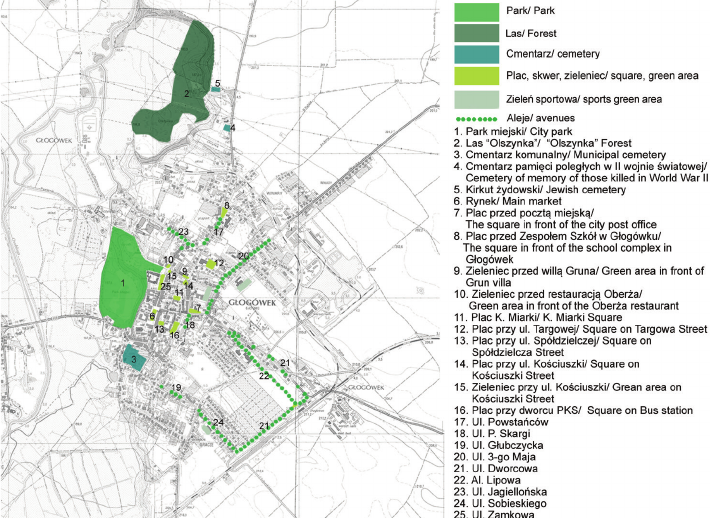
At present, numerous public green areas can be found in
Głogówek (Figs. 6–8). These include gardens and greens
with historic character, as well as newly created sites.
Street greenery, parks, garden and town squares can still
be found in the city, as well as green areas in cemeteries.
It is also possible to distinguish publicly accessible sports
complexes that had not been there previously. In the spatial
analysis of green spaces, the scattered distribution pattern
of the sites is notable. It is not possible to read a clear sys-
tem of gardens that would be interconnected in the urban
layout. They also do not form a coherent whole in compo-
sitional terms.
Of the historic areas in the town plan, the town park
still distinguishes itself the most. It is fully accessible to
residents. In the last twenty years it has undergone partial
revalorisation consisting mainly of improvements to the
trac and circulation infrastructure. New structures and
zones have also been created in its area, such as squares,
playgrounds, Jordan gardens and nature trails.
The urban forest dubbed “Olszynka” became a second
major element in the layout. Once located outside the com-
pact development structure, it is now a popular place for
residents to walk. Essentially, there is no clear composi-
tional layout here and the whole is centred on naturally
formed scrub woodland. Vehicular trac is handled by an
asphalt road that leads to the community development, and
pedestrian paths do not have a clear compositional layout.
There is also a lack of garden features.
In terms of street greenery, only a few of the historic
avenues have survived in the town’s urban interiors. Es-
sentially, relics of former plantings formed by old-growth,
small-leaved lime trees can be found along several roads,
PublicgreeneryinGłogówekfromthe19
th
centurytothepresentday:Ananalysisofhistoricalandcompositionalchanges 87
Fig. 6. Public greenery
in Głogówek – today
(elaborated by A. Steuer-Jurek
based on topographic map
obtained from:
Główny Urząd Geodezji… 2024)
Il. 6. Zieleń publiczna
w Głogówku – współcześnie
(oprac. A. Steuer-Jurek na
podstawie mapy topograficznej
z:
Główny Urząd Geodezji… 2024)
but their original compositional arrangement can no longer
be read. Only the two pedestrian promenades leading to
the railway station (now Lipowa Avenue and Dworcowa
Street) have survived in their entirety. The rst of these
was protected as a monument to nature in 2022 (Uchwała
Rady Miejskiej… nr LII/450/2022). Initial stages of work
on recreating old avenue plantings can be observed in the
town. Several streets have new trees (dominated by small-
leaved lime trees).
The cemetery greenery is maintained in good condition.
At the municipal (formerly parish) cemetery in the early
21
st
century, extensive restoration and decluttering work
was carried out. The paths have been repaired, a lapidarium
has been created and part of the former lime avenues have
been preserved. The cemetery of those who died during the
World War II is in a good state of repair and the whole is
tidy and well-maintained. The Jewish cemetery has under-
gone cleaning over the past ten years thanks to the eorts
of local residents, although the tombstones and fence are
not in good technical condition. However, the entrance to
the Protestant cemetery has been closed and it is no longer
part of the public green space. The site is currently untidy
with numerous self-sown trees. The tombstones there have
been largely damaged.
The term “sports greenery” is used to describe newly
developed facilities within the city, such as “Orlik” foot-
ball pitches or skate parks. They are located close to pri-
mary schools, but can also be accessed outside of school
hours. In the context of green space planning, elements of
a planned compositional layout are missing here. Mostly
there are self-sown or accidental plantings from earlier
years. There are also other sports facilities in the town, but
they are not open to the public and therefore do not func-
tion as public spaces.
The last type of greenery found in Głogówek are town
and garden squares (Fig. 8). Their number has noticeably
increased, although this does not translate into quality of
composition and architectural solutions. The square in front
of the post oce has retained its original form. The basic
circulation layout partly refers to previous solutions. Study
visits found that the paved area in the square in front of the
post oce façade had been enlarged. New planting com-
positions have been introduced that do not form a coher-
ent, well-planned whole. Individual plants from the his-
toric layout (mainly common ash trees) can be seen in the
area. The garden square next to the former teachers’ sem-
inar (now the Głogówek School Complex) has remained
within its original boundaries and has kept its composition
unchanged. Along the main path are mainly horse chestnut
trees. In terms of landscaping, only three benches, litter
bins and a notice board can be mentioned. The lack of this
space’s comprehensive design, including an absence of
plant compositions or garden features means that it is not
attractive to residents.
In terms of urban greenery, attention we should note the
composition of the planting in the market square, which
references the layout from the early 20
th
century (Fig. 7).
Although it is not a faithful reproduction, the way the
plots are shaped and the choice of plant species (com-
mon maples in the globular variety) harmonises with the
surrounding architecture and emphasises its features and
corresponds to urban conditions. The situation is less fa-
vourable in other parts of the market, where concrete and
wooden pots with coniferous plants, as well as annuals,
have been placed. Such furnishings blend badly with the
Baroque architecture of the surroundings and the formal
character of the place.
There are also a number of other squares in the town that
are essentially urban gardens built in the late 20
th
century.
They essentially do not display high aesthetic value, do not
feature a dominant compositional style, modern solutions or
layouts that would reference place-based history or tradition.
88 Anna Steuer-Jurek
Most of these sites are based on the existing layout of tall
vegetation, with a small proportion of other types of green-
ery such as ornamental shrubs, perennials and climbers.
The garden squares, especially in formal areas, are dom-
inated by coniferous species and plants with contrasting
leaf colour. Nonetheless, because of their garden character,
they provide a place for residents to walk and relax
11
.
11
This conrms the view that attempts to adapt spaces to the needs
of modern users can be seen in cities. The cultural value and social per-
ception of these places do not depend on the size of the area or the qual-
ity of the vegetation – artistic and social phenomena play a major role
(Waryś 2016, 236, 237).
There are also open spaces of estate greenery in the urban
landscape. Complex vegetation planting systems were not
found to be present during the survey. Biologically vital ar-
eas were limited to lawns, individual owerbeds and a few
mature trees or shrubs. Although these areas are open to
the public, due to belonging to estate homeowners’ associa-
tions they are not considered part of the public green space.
Conclusions
At present, as in the 19
th
century, green areas are starting
to play an increasingly major role in the cityscape. They
are important for both psychosocial, environmental and
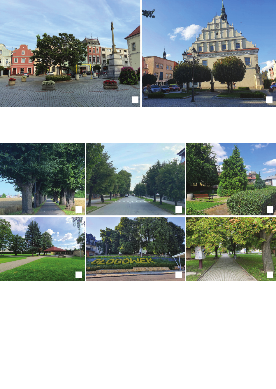
Fig. 8. Examples of public greenery in Głogówek: a) Lipowa Avenue, b) tree planting along 3 Maja Street, c) square in Kościuszki Street,
d) square in Targowa Street, e) square at the bus station, f) square at the School Complex in Głogówek (photo by A. Steuer-Jurek, 2024)
Il. 8. Przykłady zieleni publicznej na terenie Głogówka: a) al. Lipowa, b) nasadzenia drzew wzdłuż ul. 3 Maja, c) plac przy ul. Kościuszki,
d) plac przy ul. Targowej, e) plac przy dworcu PKS, f) plac przy Zespole Szkół w Głogówku (fot. A. Steuer-Jurek, 2024)
a
d
c
f
b
e
a b
Fig. 7. Głogówek market square: a) north side, b) south side (photo by A. Steuer-Jurek, 2024)
Il. 7. Rynek w Głogówku: a) strona północna, b) strona południowa (fot. A. Steuer-Jurek, 2024)
PublicgreeneryinGłogówekfromthe19
th
centurytothepresentday:Ananalysisofhistoricalandcompositionalchanges 89
References
Chrzanowski, Tadeusz. Śląskwzabytkachsztuki: Głogówek. Ossolineum,
1977.
Derkacz, Aleksandra, Łukasz Szała, and Marek Szała. “Z przeszłości
miasta.” In Ziemia Głogówecka, edited by Aleksandra Derkacz, Łu-
kasz Szała, Marek Szała, Aleksander Devosges Cuber, and Elżbieta
Romanowska. Towarzystwo Miłośników Głogówka, 2009.
Główny Urząd Geodezji i Kartograi. “Geoportal Krajowy.” Accessed
July 20, 2024, at https://mapy.geoportal.gov.pl/.
Główny Urząd Statystyczny. “Powierzchnia i ludność w przekroju tery-
torialnym w 2024 roku.” Published July 22, 2024. Accessed July 24,
2024, at https://stat.gov.pl/obszary-tematyczne/ludnosc/ludnosc/po-
wierzchnia-i-ludnosc-w-przekroju-terytorialnym-w-2024-roku,7,21.
html.
Hauptstock, Günter. MójGłogówek. MS Bogusław Szybkowski, 2016.
Hauptstock, Günter. Z dziejów Głogówka. MS Bogusław Szybkowski,
2009.
Jäger, Hermann. Lehrbuchdergartenkunst:oderLehrvonderAnlageAus-
schmückungundKünstlerischenunterhalungderGärtenundfreien
Anlagen. Hugo Voigt, 1877.
“Karte des Deutschen Reiches.” Blatt 499 Cosel, 1:100 000. 1886. Ac-
cessed July 21, 2024, at https://www.bibliotekacyfrowa.pl/dlibra/
publication/115479/edition/106308?language=en.
Kłuskiewicz, Jarosław. WspomnieniazGłogówka. MS Bogusław Szyb-
kowski, 2018.
Kłuskiewicz, Jarosław, and Barbara Grzegorczyk. Głogóweknadawnej
pocztówce. MS Bogusław Szybkowski, 2008.
Koch, Hugo. GartenkunstimStädtebau. Wasmuth, 1914.
Kosian, Alfred. FührerdurchdasschöneOberglogau.DerSinnderGes-
chichteeineroberschlesischenKleinstadt. E. Radek, 1931.
Legendziewicz, Andrzej. “Gotycka architektura kościoła kolegiackiego
w Głogówku i jej przekształcenia do schyłku XVIII wieku.” Wia-
domości Konserwatorskie – Journal of Heritage Conservation 66
(2021): 47–64. https://doi.org/10.48234/WK66COLLEGIATE.
Majdecki, Longin. Historiaogrodów. Vol. 2. OdXVIIIwiekudowspół-
czesności. PWN, 2008.
Messtischblatt. 1:25000. 1883. Accessed July 16, 2024, at http://maps.ma-
pywig.org/m/German_maps/series/025K_TK25/5673_(3303)_Ober-
Glogau_1883_IfL.jpg. [Manuscript in: Leibniz-Institut für Länderkunde].
visual reasons. Based on the presented changes that oc-
curred over successive periods, we can assume that public
greenery that is designed in an informed manner contrib-
uted to the town becoming an artistically and functional-
ly mature organism over its periods of development. In
Głogówek, the greatest growth in the number of complex-
es and the development of garden forms took place when
specialist bodies were created. They signicantly contrib-
uted to producing an aesthetically pleasing and cohesive
image of the urban layout. Currently, despite increasing
the number of generally accessible green areas, it is dif-
cult to rate them as harmonious due to their artistic and
ecological quality.
In a town with a historic structure and distinctive Ba-
roque development dominating its centre, it is essential
for contemporary greenery to be an integral part of this
place’s identity. It is therefore considered crucial to take
deliberate measures to connect greenery to the surrounding
architecture. At present, unfortunately, two extremes can
be observed here. Koch (1914, 1, 2) wrote about the rst
– he pointed out that one of the biggest problems in urban
planning is the failure to entrust a specialist (landscape ar-
chitect) with the planning of the overall greenery system.
The second issue, already noted in the 19
th
century, is
the tendency of designers to manifest their individuality,
leading to a public green spaces losing cohesion (Jäger
1877, 624).
In Głogówek, due to the spatial scale, attention should
be paid to designing greenery complexes as a unied sys-
tem that consists of interconnected areas. In today’s town
and garden squares, one can observe the creation of sep-
arate miniature landscapes that are not adapted to their
surroundings. It is therefore advisable to treat green com-
plexes as a whole by creating sequences of architectural
interiors. It is necessary to adapt the layout and species
selection to the scale of a given urban garden and its sur-
rounding architecture. In both the revalorisation of histor-
ical compositions and contemporary developments, a cer-
tain order should be sought and coherent elements should
be introduced. Such solutions were already used in the town
in the past (e.g., the unication of interior features). The
greenery should also highlight points of formal impor-
tance in a city’s urban plan, which will allow for better
identication and the construction of a place’s identity. It
is also worth considering the restoration of former avenue
layouts along the main urban arterials, which is consistent
with the historic image of the town. This procedure does
not infringe on current legislation, including § 72 (Roz-
porządzenie Ministra Infrastruktury… 2022) on technical
regulations concerning roads.
When talking about urban greenery, it is also import-
ant to pay attention to the natural and ecological potential
of these places. It was noted that currently in Głogówek
the
selection of plant species is signicantly limited, which
poses a signicant challenge. For environmental and safety
reasons, the plant species used should be adapted to ur-
ban conditions, while at the same time not impeding trac
or obscuring the architecture. Therefore, the small-leaved
lime trees or the common maples in the globular variety,
which grew in the area in the past, seem to be the right
choice. At the same time, we should aim to enhance biodi-
versity in urban spaces by introducing varied plant types.
This is crucial not only for environmental conservation
reasons or aesthetic pleasantness, but also creating ecolog-
ical enclaves.
By learning about how public greenery in Głogówek
transformed, a more accurate characterisation of the town
can be made. At the same time, the study presented can
help to develop strategies and directions for the develop-
ment of the greenery system based on historical patterns.
It can also raise awareness that public gardens aid in de-
veloping cities, both spatially and socially. They are an ex-
pression of place-based identity and allow connecting his-
torical and contemporary buildings, contributing to a better
identication of the city in its region.
Translatedby
KrzysztofBarnaś
90 Anna Steuer-Jurek
Messtischblatt. 1:25000. 1913. Accessed July 20, 2024, at http://maps.
mapywig.org/m/German_maps/series/025K_TK25/5673_(3303)_
Ober-Glogau_1913_UPKrak.jpg. [Manuscript in: Instytut Geograi
Uniwersytetu Pedagogicznego, Kraków].
Messtischblatt. 1:25000. 1940. Accessed July 22, 2024, at http://maps.
mapywig.org/m/German_maps/series/025K_TK25/5673_Ober-
glogau_1940.jpg. [Manuscript in: The University of California Ber-
keley Library].
Mierzejewska, Lidia. “Zieleń miejska jako przestrzeń publiczna.” In
Przestrzeńpublicznamiast.XXIVKonwersatoriumWiedzyoMieś-
cie, edited by Iwona Jażdżewska. Wydawnictwo Uniwersytetu Łódz-
kiego 2011.
OberglogauerStadtblatt 1905, May 15, no. 55.
OberglogauerStadtblatt 1906, April 25, no. 49.
OberglogauerStadtblatt 1906, November 14, no. 136.
OberglogauerStadtblatt 1929, June 8, no. 86.
Paraa pw. św. Bartłomieja w Głogówku. “Cmentarz Komunalny w Gło-
gówku. Historia.” Accessed July 24, 2024, at https://cmentarz.glogovia.
pl/index.php?id=historia.
“Plan Głogówka z 1811 r.” Archiwum Państwowe w Opolu, sygn. RO
IX/19.
“Program Ochrony Środowiska dla Gminy Głogówek na lata 2021–2024.
Projekt.” Edited by EkoLogika Mariusz Orzechowski. Accessed July
24, 2024, at https://bip.glogowek.pl/2809/program-ochrony-srodo-
wiska-dla-gminy-glogowek-na-lata-2021-2024.html.
Próchnicka, Emilia, and Franciszek Czyżowski. “Ewidencja parku zam-
kowego w Głogówku.” Opole 1987. [Manuscript in Wojewódzki
Urząd Ochrony Zabytków, Opole].
Przybyłok, Arkadiusz. “Mury miejskie na Górnym Śląsku w późnym śre-
dniowieczu.” PhD diss., Uniwersytet Łódzki, 2014.
Romanowska, Elżbieta. “Przyroda Głogóweckiej ziemi.” In Ziemia Gło-
gówecka, edited by Aleksandra Derkacz, Łukasz Szała, Marek Szała,
Aleksander Devosges Cuber, and Elżbieta Romanowska. Towarzy-
stwo Miłośników Głogówka, 2009.
Rozmarynowska, Katarzyna. Ogrodyodchodzące…? Fundacja Terytoria
Książki, 2017.
“Rozporządzenie Ministra Infrastruktury z dnia 24 czerwca 2022 r. w spra-
wie przepisów techniczno-budowlanych dotyczących dróg publicz-
nych.” Dz. U. z 2022 r., poz. 1518. Accessed July 10, 2024, at https://
isap.sejm.gov.pl/isap.nsf/download.xsp/WDU20220001518/O/
D20221518.pdf.
Schermuly, Josef Eduard. Das Lehrer-Seminarzu Ober-Glogau: Fest-
schriftzurJubelfeierseineshundertjährigenBestehensam12.Mai
1902. Ferdinand Hirt, 1902.
Schmidlin, Eduard. Die bürgerliche Gartenkunst oder Praktische An-
leitung zur zweckmässigen Anlage, Eintheilung und Best. Ho-
mann’sche Verlags-Buchhandlung, 1863.
Schnurpfeil, Heinrich. “Geschichte und Beschreibung der Stadt Ober-
Glogau in Oberschlesien: mit der Genealogie der Grafen von Op-
persdorf. Oberglogau.” Commission bei Heinrich Handel, 1860.
Siewniak, Marek, and Anna Mitkowska. Tezaurus sztuki ogrodowej.
Rytm, 1998.
Strecke, Josef, ed. Festschriftzur700-JahrfeierderStadt Oberglogau.
Verlag der Stadt Oberglogau, 1925.
Sutkowska, Eliza. “Współczesny kształt i znaczenie zieleni miejskiej
jako zielonej przestrzeni publicznej w strukturze miasta – przestrzeń
dla kreacji.” TekaKomisjiArchitekturyUrbanistykiiStudiówKrajo-
brazowych, 2 (2006): 184–92.
Steuer-Jurek, Anna. “Kultywowanie miejsc pamięci na przykładach cmen-
tarzy w Głogówku.”Przestrzeń,Urbanistyka,Architektura 1 (2019):
133–44. https://doi.org/10.4467/00000000PUA.19.010.10013.
“Uchwała Rady Miejskiej w Głogówku nr LII/450/2022 z dnia 28 stycz-
nia 2022 r. w sprawie ustanowienia pomnika przyrody Alei Lipowej
w Głogówku.” Accessed July, 20 2024, at https://bip.glogowek.pl/
download/attachment/11602/450-w-spr-ustanowienia-pomnika
-przyrody-alei-lipowej-wglogowku.docx.
Urmesstischblatt. 1 : 25.000. 1825. Staatsbibliothek zu Berlin, syg. Kart.
N 729.
Waryś, Ewa. “Znaczenie angielskich skwerów miejskich w krajobrazie
zurbanizowanym.”TekaKomisjiUrbanistykiiArchitekturyOddział
PANwKrakowie 44 (2016): 233–40.
Wrobel, Ralph M. “Die Entstehung des Gärtnerstandes in der Herrschaft
Oberglogau.” OberschlesischesJahrbuch, no. 9 (1993): 67–81.
Wrobel, Ralph M. “Die Gründung und frühe Entwicklung der Stadt Ober-
glogau.”OberschlesischesJahrbuch, no. 20 (2004): 13–66.
Streszczenie
Zieleń publiczna w Głogówku od XIX w. do czasów współczesnych. Analiza przemian historyczno-kompozycyjnych
Zieleń publiczna stanowi istotny element układu urbanistycznego miasta. Świadomie kształtowana na różnych etapach rozwoju sprawia, że staje
się ono dojrzałym artystycznie i funkcjonalnie organizmem. W Głogówku pierwsze układy komponowanej zieleni publicznej zostały zauważone
w XIX w. Wraz z rozwojem przemysłu i powiększeniem się miasta powstawały nowe miejskie ogrody publiczne – tworzyły wyraźny system w ukła-
dzie przestrzennym. Obecnie liczba zespołów zieleni publicznej zwiększyła się, nie tworzą już one jednak uporządkowanego i połączonego systemu.
W artykule nakreślono charakterystykę zieleni publicznej w Głogówku. Przeanalizowano przemiany, jakie zachodziły od XIX w. do czasów współ-
czesnych. Dzięki temu można było sprecyzować wytyczne zarówno dotyczące rewaloryzacji, jak i kierunków dalszego rozwoju. Mają one na celu
wypracowanie systemu ogrodów miejskich opartego na historycznych wzorcach i tożsamości miejsca.
Dostępne materiały archiwalne, w tym w szczególności kartograczne oraz ikonograczne, posłużyły do scharakteryzowania systemu zieleni pu-
blicznej w mieście, a także przemian, jakie w nim zachodziły. W badaniach sięgnięto również po literaturę przedmiotu i odniesiono się do wytycznych
projektowych, analogii i szerszego kontekstu. Stan współczesny został określony na podstawie badań in situ.
Po analizie wyników badań można przyjąć, że świadomie kształtowana zieleń publiczna ma duże znaczenie – jest bowiem jednym z wyrazów
tożsamości miejsca pozwalających nie tylko na połączenie historycznej i współczesnej zabudowy, lecz także na lepszą identykację miasta w regionie.
Słowa kluczowe: miejskie ogrody publiczne, krajobraz miasta, tożsamość miejsca, systemy zieleni, Śląsk