2020
2(62)
DOI: 10.37190/arc200206
Introduction
El Fuerte de Samaipata is an archaeological site in the
department of Santa Cruz in Bolivia, located on a rocky
hill at an altitude of about 1950 m above sea level. The site
was constructed and occupied by the Mojocoyas culture
in the fourth century, and it was during this time that the
rock began to be carved. In the 15
th
century, the site was
conquered by the Inca, who made it a provincial capital.
The strategic location of the site was also recognised by
the Spaniards, who made it an important staging post on
the road from Asunción and Santa Cruz to La Plata (mod-
ern Sucre), Cochabamba, and Potosí (where silver mines
were located) [1].
The archaeological site consists of two parts: the cere-
monial part (14
th
–16
th
centuries), and the area to the south
– the residential and administrative part. The ceremonial
part is a sculpted rock that is 250 m long and 60 m wide,
which makes it one of the largest collection of petroglyphs
in the world. The sandstone was carved to create niches,
canals, and zoomorphic designs such as snakes and wild
cats like pumas and jaguars [2].
Bartłomiej Ćmielewski*, Izabela Wilczyńska**,
Ciechosław Patrzałek***, Jacek Kościuk****
Digital close-range photogrammetry of El Fuerte de Samaipata
Cyfrowa fotogrametria bliskiego zasięgu El Fuerte de Samaipata
In this article, we present the results of using a non-met-
ric camera as a tool in terrestrial close-range photogram-
metry for documentation of El Fuerte de Samaipata as
part
of the project “Architectural examination and complex
documentation of Samaipata (Fuerte de Samaipata/Bolivia).
The place on the World Heritage List”, funded by The Na-
tional Science Centre Poland.
Methods
Nowadays, 3D data are extremely useful for perma-
nently storing and documenting important sites in digital
form. Sometimes, they may be the last form to be passed
to the next generations (for example, as heritage may be
destroyed in wars). With technical progress, a large num-
ber of projects now have complete digital models [3]–
[8]. Remote sensing technologies and methodologies are
common for cultural heritage 3D documentation and mo -
deling [9]. They allow very realistic 3D models (in terms
of geometric and radiometric accuracy) to be generated.
Such models can be used for many purposes, including
historical documentation [10], [11], preservation and con-
servation [12], [13], cross-comparisons, monitoring shape
and colour, virtual reality applications [14], [15], 3D re-
positories, web-based Geographic Information System
(GIS), computer-aided restoration [16], multimedia exhi-
bitions [17], and simple visualisations.
The documentation and conservation of cultural herit-
age depends on the availability of means and resources.
Data repositories allow the present state of a site to be de-
scribed and provide metrical information, which is useful
for direct restoration of objects. Nowadays, digital pho-
togrammetry is used in many applications, especially in
* ORCID: 0000-0002-1035-3905. Faculty of Architecture,
Wrocław University of Science and Technology, e-mail: bartlomiej.
cmielewski@pwr.edu.pl
** ORCID: 0000-0002-1397-8118. Faculty of Environmental
Engineering and Geodesy, Wrocław University of Environmental and
Life Sciences.
*** ORCID: 0000-0002-0853-5494. Faculty of Environmental
Engineering and Geodesy, Wrocław University of Environmental and
Life Sciences.
**** ORCID: 0000-0003-0623-8071. Faculty of Architecture,
Wroc ław University of Science and Technology.
36 Bartłomiej Ćmielewski, Izabela Wilczyńska, Ciechosław Patrzałek, Jacek Kościuk
cartography and mapping. It is also used for precise 3D
documentation of cultural heritage [5], [11], [18]–[20],
reverse engineering, monitoring and deformation analy-
ses of structures [21], human movement analyses [22], in-
dustrial measurements [23], urban planning, and forensic
analyses [24]. Innovations in the eld of photogrammetry,
especially matching algorithms, increase of the quality of
spatial data obtained by images.
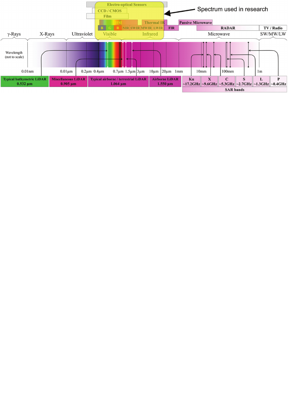
Sensors
Remote sensing involves the sensing of energy in parts
of the electromagnetic spectrum (Fig. 1), which is the con-
tinuous range of electromagnetic radiation from gamma
rays, through visible light, to radio waves.
To create documentation for archaeological, architec -
tural, and conservation purposes, it is common to use multi-
spectral or hyperspectral sensors that provide images from
satellites. These are commonly considered in literature to
be successful [26]. Other solutions are based on terrestrial
cameras, which also provide good results [27]–[29].
While RGB orthoimages are used for documentation
purposes, another indicator, the Normalised Dierence
Vegetation Index (NDVI), is commonly used in remote
sensing measurements and allows the developmental state
and condition of vegetation to be determined. Vegetation
interacts with solar radiation, weather conditions, and
the nutrients and water content on its roots (usually from
soil). The NDVI can show where soil has more moisture
(which can indicate underground constructions like hid-
den walls) or places that have been degraded by vegeta-
tion – like in the case of Samaipata. The NDVI is based on
the contrast between the largest reection in the near-in-
frared band (which vegetation strongly reects) and the
red band (which vegetation absorbs). The indicator was
used for the rst time by John W. Rouse et al. in 1973 [30]
and is calculated according to the following formula (1):
(1)
where:
VIS – reection in the red band,
NIR – reection in the near-infrared band.
Vibrant, green plants absorb photosynthetically active
solar radiation in the range of 0.4–0.7 μm. Radiation with
longer wavelengths (0.7–1.1 μm) is absorbed to a small
extent. The NDVI ranges from –1 to 1. Higher index val-
ues correspond to a higher reection in the near-infrared
range and a smaller reection in the red range. A high val-
ue of the indicator corresponds to areas covered with lush
vegetation in good condition [31].
Materials and methods
RGB camera
For the close-range photogrammetry, we used an
ILCE-7RM2 DSLR camera from Sony. It has a full frame
(35.9 × 24.0 mm) CMOS Exmor R
®
sensor and eective
resolution of 42.4 megapixels (image resolution 7952 ×
5304). The pixel dimension is 4.53 × 4.53 µm, which pro-
vides good sensitivity.
Multispectral camera
For multispectral analysis, we used a Parrot Sequoia
camera equipped with four monochrome sensors and one
RGB sensor. The monochrome sensors (global shutter,
1.2 megapixels) collect data in discrete spectral bands:
green (550 nm with 40 nm bandwidth), red (660 nm with
40 nm bandwidth), red edge (735 nm with 10 nm band-
width) and near infrared (790 nm with 40 nm bandwidth).
The RGB sensor (rolling shutter) has a 16 megapixel res-
olution (4608 × 3456) with a focal length of 4.88 mm. It
is complemented by a sunshine sensor with four spectral
sensors (the same lters as the body), and GPS, IMU, and
magnetometer sensors for direct geotagging.
Thermal camera
For thermal analysis, a Flir Tau 2 324 VOx Microbolo -
meter, f/13 mm, 9 Hz camera was used. It has a pixel size
of 25 µm with a better performance than 50 mK at f/1.0.
The sensing spectral band is from 7.5 to 13.5 µm and
advanced radiometry was also enabled. The TeAx Ther-
malcapture module was attached to the camera for direct
Fig. 1. Electromagnetic (EM) spectrum (after: [25])
NDVI =
—————
(NIR + VIS)
(NIR – VIS)

Digitalclose-rangephotogrammetryofElFuertedeSamaipata / CyfrowafotogrametriabliskiegozasięguElFuertedeSamaipata 37
geotagging (from GPS times and coordinates) of images
that were loaded onto an external USB memory.
Surveynetwork
The rst step was to perform a survey, so we used
a Leica TCRP1203 total station with an angular accuracy
of 3 arcsec and a distance error of 5 mm + 2 mm. Next,
we processed the data in local coordinates, and later these
were adjusted to the network. The nal step was to trans-
form the coordinates from the local to the global refer-
ence frame using isometric transformation to the WGS
84/UTM zone 20S, EPSG:32720 coordinate system and
GPS points FS01, FS02, FS03, and FS04. After adjust-
ment, the worst point average square position error was
6.8 mm and the worst point average square height error
was 2.9 mm. Using these adjusted and transformed coor-
dinates, the photogrammetric network was measured and
adjusted. The total number of photogrammetric points
was over 1500, and their distribution on the site is pre-
sented in Figure 2.
Photogrammetryprocessingresultsandworkflow
All acquired data was processed in one of the best piec-
es of software on the market – Agisoft Photoscan Profes-
sional. The workow is presented in Figure 3.
The rst step after importing images was to calculate
the image quality and remove the lowest quality images.
Next, photos were aligned. For high RGB resolutions,
the key point limit was set to 40,000 and the tie point
limit was set to 3,000. For multispectral low-resolution
images, the key point limit was set to 80,000 and the
tie point limit was set to 10,000. Such settings allowed
sustainable image quality and cloud computing power
to be used. After alignment, the markers were loaded,
and the tedious process of pointing markers in pictures
started. Next, optimisation was applied to recalculate
the lens equitation and camera location. After this step,
the error value was checked and the gradual calculation
of the reconstruction uncertainty value of tie points was
calculated. After removing values over 100, optimisation
was conducted again. This step was repeated a few times
Fig. 2. Survey point distribution (elaborated by B. Ćmielewski)
Fig. 3. Workflow for image
processing
(elaborated by B. Ćmielewski)

38 Bartłomiej Ćmielewski, Izabela Wilczyńska, Ciechosław Patrzałek, Jacek Kościuk
with the additional action of adding common points in
places where the tie point cloud and image location were
“strange” – meaning that the reconstructed location of im-
ages could not have been in such a position, or the point
cloud was divided, which happened in particular when the
multispectral low-resolution images were processed.
After achieving satisfying results – at point cloud and
low error value on check and control points – we created
a digital elevation model (DEM) and later an orthoimage
of the rock. The main statistics of processing both RGB
and multispectral images are presented in Table 1.
There were over 1500 applied markers. Some of them
were used as controls and some as check points, and the
selection of both types of points were specially selected
to evenly cover the rock area. The error values are sum-
marised in Table 2. The average 3D error both control and
check points for the RGB project was around 1.5 cm, and
for the multispectral project, 3 cm. The photogrammetric
project allowed the archaeological site to be reconstructed
with an accuracy of centimetres and a very high resolution
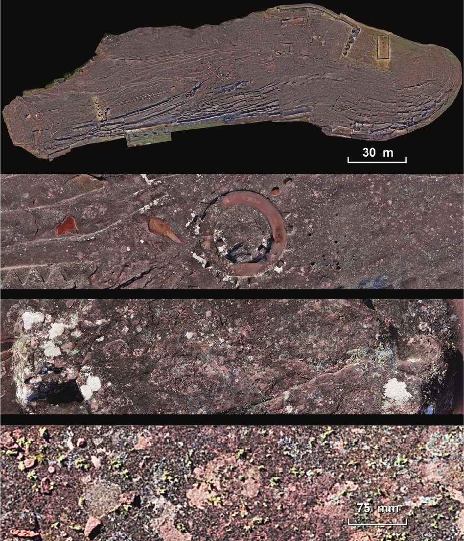
of the nal orthoimage at the level of 0.3 mm. This reso-
lution, as presented in Figure 4, allowed individual blades
of grass to be counted.
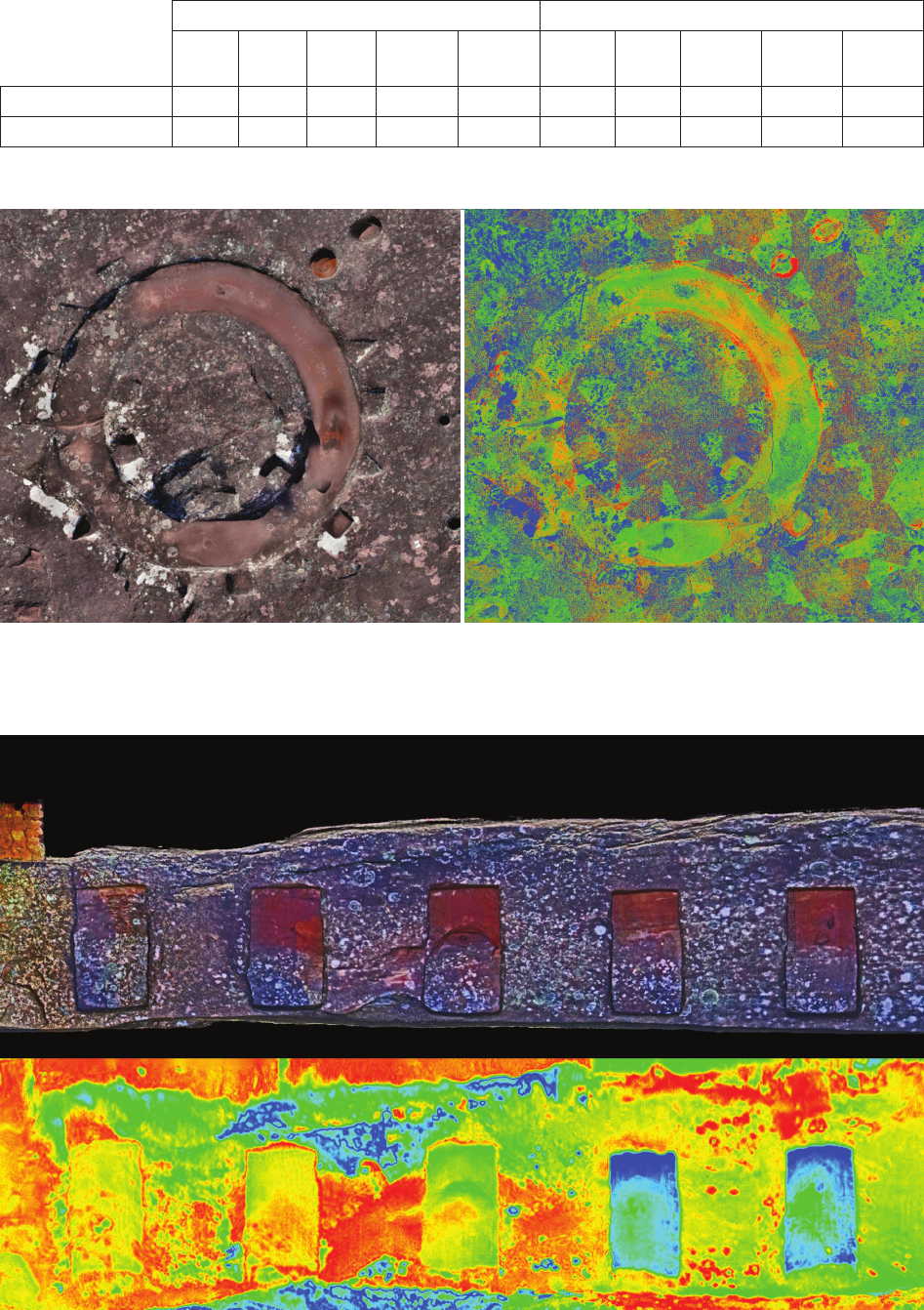
Using multispectral cameras with NDVIs, we can high-
light the places where vegetation is accelerating the ero-
sion process (Fig. 5).
Photo-alignment RGB Multispectral
Camera stations 51,128 110,684 (4 × 27,671)
Camera altitude 2.36 m 3.34 m
Coverage area 0.0292 km² 0.0213 km²
Ground resolution 0.292 mm/pixel 3.16 mm/pixel
Tie points 23,071,218 51,607,684
Projections 118,482,378 634,582,165
Reprojection error 0.647 pixels 1.14 pixels
Max reprojection error 125.92 pixels (36,77 mm) 78.69 pixels (248,66 mm)
Key points 161.48 GB 259.761 GB
Matching time 22 days 7 hours 25 days 14 hours
Alignment time 3 days 11 hours 1 hours 46 minutes
Optimisation time 37 minutes 53 seconds 5 hours 11 minutes
DEM RGB Multispectral
Size 14,267 × 5,642 pixel 19,744 × 7,359 pixel
Processing time 10 minutes 20 seconds 30 minutes 57 seconds
Resolution 1.91 cm/pixel 1.22 cm/pixel
Point density 0.274 points/cm² 0.673 points/cm²
Orthoimage RGB Multispectral
Size 931,971 × 368,254 pixel 76,075 × 28,216 pixel
Processing time 5 days 21 hours 1 days 0 hours
Colours 3 bands, uint8 4 bands, uint16
Raster Transform Expression – ((B4-B2)/(B4+B2))+0.25
Table 1. Summary of photogrammetric projects (elaborated by B. Ćmielewski)
Thermal documentation
We had problems with thermally documenting the
whole archaeological site, as it was not possible to cap-
ture the entire site at one time. The thermal colours on
the images depend on temperature, which depends on en-
vironmental conditions. We were not able to y a drone
over the whole site due to very strong wind. We could
only produce an orthoimage for part of the site captured
in a relatively short period of time. The example given in
Figure 6 presents part of a vertical wall facing south from
sector S08
1
.
Conclusions
The results of these remote sensing studies are not only
important documentation showing the current state of El
Fuerte de Samaipata, but also form the basis for further
studies. The detailed survey network established for this
project was also used during the 3D laser scanning of the
Samaipata rock.
1
Cf. J. Kościuk, G. Oreci, M. Ziółkowski, A. Kubicka, R. Muñóz
Risolazo, Description and analysis of El Fuerte de Samaipata in the
lightofnewresearch,andaproposaloftherelativechronologyofits
main elements, in the same issue of “Architectus”.
Digitalclose-rangephotogrammetryofElFuertedeSamaipata / CyfrowafotogrametriabliskiegozasięguElFuertedeSamaipata 39
The high-resolution orthoimage was, together with
the results of 3D laser scanning, the basis for drawing up
a detailed CAD plan of all the terraces, niches, reservoirs,
canals, and petroglyphs densely covering the entire rock
surface. As both the photogrammetric studies and 3D
laser scanning results were embedded in an analogous
coordinate system that guaranteed their correlation, they
were extremely important when preparing the vector plan.
Some details of the complex were better visible either on
the orthoimages made on the basis of photogrammetric
studies or on orthoimages obtained from terrestrial laser
scanning (TLS). In a few cases, the best source for inter-
preting the most eroded features were digital terrain model
(DTM) images rendered with hill-shading algorithms.
Multispectral orthoimages also proved to be extremely
useful – they allowed the current state of the spreading of
lichen, fungi, and algae attacking the surface of the rock to
be documented. In the future, if such a study is repeated,
the orthoimages produced in this project will allow the
speed of progressing biological erosion to be determined.
Fig. 4. View of the Samaipata rock followed by images zoomed into the central part of the main orthoimage (elaborated by B. Ćmielewski)
40 Bartłomiej Ćmielewski, Izabela Wilczyńska, Ciechosław Patrzałek, Jacek Kościuk
Fig. 6. Juxtaposition of the RGB and thermal images
(elaborated by J. Kościuk)
RGB project accuracy Multispectral project accuracy
x error
[cm]
y error
[cm]
z error
[cm]
xy error
[cm]
total
[cm]
x error
[cm]
y error
[cm]
z error
[cm]
xy error
[cm]
total
[cm]
Control points RMSE 0.934 1.076 2.628 1.426 2.989 2.447 1.705 2.527 2.983 3.910
Check points RMSE 0.855 1.112 3.560 1.403 3.827 2.654 1.956 3.532 3.297 4.832
Table 2. Accuracy of control and check points in photogrammetric projects (elaborated by B. Ćmielewski)
Fig. 5. Comparison of RGB (A) and multispectral (B) orthoimages
(elaborated by B. Ćmielewski)
A B
Digitalclose-rangephotogrammetryofElFuertedeSamaipata / CyfrowafotogrametriabliskiegozasięguElFuertedeSamaipata 41
If a restoration project ever starts, the results obtained by
us will be an important reference material to monitor the
eectiveness of actions taken.
An important limitation and drawback of the research
was the choice of season in which the measurements were
taken. Theoretically, June and July should be the months
of the lowest precipitation in Samaipata. However, the
2016 season was unusual in this respect – during our 60-
day stay, we recorded only 20 days without rainfall. In
addition, unusually strong winds did not allow us to use
the drone, which in turn forced the team to take almost
References /Bibliografia
[1] El Fuerte de Samaipata, https://whc.unesco.org/en/list/883/ [ac-
cessed: 26.08.2019].
[2] Skarby świata: 890 pomników kultury i przyrody z Listy Świa-
towegoDziedzictwaUNESCO, J. Egert-Romanowska, K. Duran,
M. Kali nowska (wyd.), Wydawnictwo Naukowe PWN, Warszawa
[2010].
[3] Levoy M., Pulli K., Curless B. et al., The Digital Michelangelo
Project:3DScanningofLargeStatues, [in:] J.R. Brown, K. Akeley
(chairmans), ProceedingsofSIGGRAPH’00,The27
th
Internation-
alConferenceonComputerGraphicsandInteractiveTechniques”
23–28July2000, New Orleans,LA,USA, ACM Press–Addison-
Wesley Publishing, New York, NY, 2000, 131–144, doi: 10.1145/
344779.344849.
[4] Bernardini F., Rushmeier H., Martin I.M., Mittleman J., Taubin G.,
Building a digital model of Michelangelo’s Florentine Pieta, “IEEE
Computer Graphics and Applications” 2002, Vol. 22, Iss. 1, 59–67,
doi: 10.1109/38.974519.
[5] Gruen A., Remondino F., Zhang L., Photogrammetric reconstruc-
tionoftheGreatBuddhaofBamiyan,Afghanistan, “The Photo-
grammetric Record” 2004, Vol. 19, Iss. 107, 177–199, doi: 10.1111/
j.0031-868X.2004.00278.x.
[6] Guidi G., Beraldin J.A., Atzeni C., Highaccuracy3Dmodelling
ofculturalheritage:TheDigitizingofDonatello’s“Maddalena”,
“IEEE Transactions on Image Processing” 2004, 13, 370–380,
doi: 10.1109/tip.2003.822592.
[7] El-Hakim S., Beraldin J., Remondino F., Picard M., Cournoyer L.,
Baltsavias E., UsingTerrestrialLaserScanningandDigitalImages
forthe3DModellingoftheErechteion,AcropolisofAthens, [in:]
ProceedingsofDMACHConferenceonDigitalMediaanditsAp-
plicationsinCulturalHeritage,3–6November2008,Amman,Jor-
dan, Amman 2008, 3–16, https://www.semanticscholar.org/paper/
Using-Terrestrial-Laser-Scanning-and-Digital-Images-El-Hakim-
Beraldin/06d006e5ebbe109db04cca877cd0991c6c440dd6.
[8] Remondino F., El-Hakim S., Girardi S., Rizzi A., Benedetti S.,
Gonzo L., 3D Virtual Reconstruction and Visualization of Com-
plex Architectures – The 3D-ARCH Project, “The International
Archives of the Photogrammetry, Remote Sensing and Spatial
Information Sciences” 2009, Vol. XXXVIII-5/W1, https://www.
isprs.org/proceedings/XXXVIII/5-W1/pdf/remondino_etal.pdf.
[9] Remote Sensing for Archaeological Heritage Management. Pro-
ceedings of the 11
th
EACHeritageManagementSymposium,Rey-
kjavík,Iceland,25–27March2010, D.C. Cowley (ed.), Europae
Archaeologia Consilium, Association Internationale sans But Lu-
cratif, Siège social, Bruxelles 2011.
[10] Doneus M., Neubauer W., Laserscannersfor3Ddocumentation
of stratigraphic excavations, [in:] M. Baltsavias, A. Gruen, M. Pa-
teraki, L. Van Gool (eds.), Recording,ModelingandVisualization
ofCulturalHeritage.ProceedingsoftheInternationalWorkshop,
CentroStefanoFranscini,MonteVerita,Ascona,Switzerland,May
22–27,2005, Taylor & Francis, London 2006, 193–204.
[11] El-Hakim S., Gonzo L., Voltolini F. et al., Detailed3Dmodellingof
castles, “International Journal of Architectural Computing” 2007,
Vol. 5, Iss. 2, 199–220, doi: 10.1260/1478-0771.5.2.200.
[12]
Akca D., Remondino F., Novak D., Hanusch T., Schrotter G., Gruen A.,
RecordingandModellingofCulturalHeritageObjectswithCoded
StructuredLightProjectionSystems, [in:] S. Campana (ed.), From
spacetoplace.2.InternationalConferenceonRemoteSensingin
Archaeology.Proceedingsofthe2.internationalworkshop,CNR,
Rome, Italy, December 2–4, 2006, Archaeopress, Oxford 2006,
375–382.
[13] Remondino F., Rizzi A., Agugiaro G. et al., Geomatics and Geoin-
formaticsforDigital3DDocumentation,FruitionandValorization
ofCulturalHeritage, [in:] ProceedingsofEUROMED2010Work-
shop“MuseumFutures:EmergingTechnologicalandSocialPar-
adigms”,8–13November2010,Lemessos,Cyprus, https://www.
researchgate.net/publication/323245824_Geomatics_and_Geo-
informatics_for_the_Digital_3D_Documentation_Fruition_and_
Valo rization_of_Cultural_Heritage [accessed: 14.06.2019].
[14] VirtualRealityinArchaeology, A. Barceló, M. Forte, D.H. Sanders
(eds.), BAR International Series, Oxford 2000.
[15] Bruno F., Bruno S., De Sensi G., Luchi M.L., Mancuso S., Muz-
zupappa M., From 3D reconstruction to virtual reality: A com-
pletemethodologyfordigitalarchaeologicalexhibition, “Journal
of Cultural Heritage” 2010, Vol. 11, Iss. 1, 42–49, doi: 10.1016/
j.culher.2009.02.006.
[16] Fowles P.S., Larson J.H., Dean C., Solajic M., The laser recording
andvirtualrestorationofawoodensculptureofBuddha, “ Journal
of Cultural Heritage” 2003, Vol. 4, Suppl. 1, 367–371, doi: 10.1016/
S1296-2074(02)01141-X.
[17] Remondino F., Rizzi A., Girardi S., Petti F., Avanzini M., 3Dich-
nology – Recovering digital 3D models of dinosaur footprints,
“The Photogrammetric Record” 2010, Vol. 25, Iss. 131, 266–282,
doi: 10.1111/j.1477-9730.2010.00587.x.
[18] Yastikli N., Documentation of cultural heritage using digital
photogrammetry and laser scanning, “Journal of Cultural Heri -
tage” 2007, Vol. 8, Iss. 4, 423–427, doi: 10.1016/j.culher.2007.06.
003.
[19] Themistocleous K., Ioannides M., Agapiou A., Hadjimitsis D.G.,
The methodology of documenting cultural heritage sites using
photogrammetry,UAV,and3Dprintingtechniques:thecasestudy
ofAsinouChurchinCyprus, [in:] D.G. Hadjimitsis, K. Themisto-
cleous, S. Michaelides, G. Papadavid (eds.), Proceedings of Spie.
Third International Conference on Remote Sensing and Geoin-
formation of the Environment (RSCy2015). 16–19 March 2015,
Paphos,Cyprus, Vol. 9535, Spie, [Washington 2015], doi: 10.1117/
12.2195626.
[20] Dhonju H.K., Xiao W., Sarhosis V. et al., FeasibilityStudyofLow-
CostImage-BasedHeritageDocumentationinNepal, “The Inter-
national Archives of the Photogrammetry, Remote Sensing and
Spatial Information Sciences” 2017, Vol. XLII-2/W3, 237–242,
doi: 10.5194/isprs-archives-XLII-2-W3-237-2017.
[21] Hampel U., Maas H.G., Application of Digital Photogrammetry
forMeasuringDeformationandCracksduringLoadTestsinCivil
Engineering Material Testing, [in:] A. Gruen, H. Kahmen (eds.),
Optical3-Dmeasurementtechniques.Applications inGIS,map-
ping,manifactoring,qualitycontrol,robotics,navigation,mobile
40,000 photos from ground level. This number of photos
obviously had to result in longer photogrammetric calcu-
lations.
Periodic monitoring of the state of preservation of El
Fuerte using the methods presented here seems worth rec-
ommending. However, the choice of future dates for this
monitoring should be guided by the forecast for wind and
not for precipitation. In favourable weather conditions,
a drone could collect all the material necessary for a pho-
togrammetric project of this size within no more than one
day of ights.
42 Bartłomiej Ćmielewski, Izabela Wilczyńska, Ciechosław Patrzałek, Jacek Kościuk
Abstract
The El Fuerte de Samaipata site inscribed on the UNESCO World Heritage List presents a pre-Columbian, multicultural history on the surface of a big
sandstone rock. There are several ways of creating precise, high-resolution documentation of this rock, including classic geodetic surveys, modern
high-denition surveying (terrestrial laser scanning), and close-range photogrammetry. Close-range photogrammetry is a low cost technique, and the
detailed RGB documentation provided by it aids architectural and archaeological research.
This paper presents the results of the application of close-range photogrammetry in dierent light bands (visual, infrared, and thermal). Sony
ILCE-7RM2, Parrot Sequoia, and Flir Tau2 cameras were used. The authors obtained over 50 thousand images and over 27 thousand multispectral
images (multiplied by four bands, which gave over 100 thousand single band images). The multispectral and thermal data enabled risk maps to be
created for conservation purposes.
Key words: photogrammetry, Samaipata, heritage documentation, rock art
Streszczenie
Wpisane na Listę Światowego Dziedzictwa UNESCO El Fuerte de Samaipata jest świadectwem bogatej, wielokulturowej, prekolumbijskiej historii
rzeźbienia tej wielkiej piaskowcowej skały. Opisano zastosowanie wielu sposobów precyzyjnej dokumentacji całej skały, w tym klasyczne metody
geodezyjne, nowoczesne pomiary w wysokiej rozdzielczości (naziemne skanowanie laserowe) i fotogrametrię bliskiego zasięgu. Fotogrametria
bliskiego zasięgu jest techniką niskokosztową, a dostarczona przez nią szczegółowa dokumentacja RGB pomaga w badaniach architektonicznych
i archeologicznych.
W artykule przedstawiono wyniki zastosowania fotogrametrii bliskiego zasięgu w różnych pasmach promieniowania elektromagnetycznego
( widzialnym, podczerwonym i termicznym). Zastosowano kamery Sony ILCE-7RM2, Parrot Sequoia i Flir Tau2. Autorzy zebrali ponad 50 tysięcy
obrazów RGB i ponad 27 tysięcy obrazów multispektralnych, co pomnożone przez cztery rejestrowane pasma dało w sumie ponad 100 tysięcy
pojedynczych obrazów do przetworzenia. Dane multispektralne i termiczne były szczególnie przydatne przy opracowaniu map ryzyka w celach
konserwatorskich.
Słowa kluczowe: fotogrametria, Samaipata, dokumentacja zabytków, sztuka naskalna
Acknowledgements /Podziękowania
Thepresentedworkisapartoftheresearchprojectsponsoredbythe
grantgiventotheWrocławUniversity ofScienceandTechnologyby
thePolishNationalScienceCentre(grantNo.2014/15/B/HS2/01108).
Additionally, the municipality of Samaipata, represented by Mayor
FalvioLópesEscalera,contributedtothisresearchbyprovidingtheac-
commodationduringtheeldworkinJuneandJuly2016,aswellasin
July2017.TheMinistryofCultureandTourismofBoliviakindlygrant-
edallnecessarypermits(UDAMNo.014/2016;UDAMNo.060/2017).
TheresearchwasconductedinclosecooperationwiththeCentrefor
Pre-Columbian Studies of the University of Warsaw in Cusco. Spe-
cialists from many other universities and research centres also joined
the project.
mapping,medicalimaging,VRgenerationandanimation. Papers
presented on 6
th
Conference on Optical 3D Measurement Tech-
niques”, Zurich, Switzerland, 22–25 September 2003, Chair of
Photogrammetry and Remote Sensing, Institute of Geodesy and
Photogrammetry, ETZ, Zürich 2003, Vol. 2, 80–88, https://www.
semanticscholar.org/paper/APPLICATION-OF-DIGITAL-PHO-
TOGRAMMETRY-FOR-MEASURING-Hampel-Maas/c585e-
7041596be195c6c9b350aef4139f53769dc.
[22] D’Apuzzo N., SurfaceMeasurementandTrackingofHumanBody
PartsfromMultiStationVideoSequences, Ph.D. Thesis, Institute
of Geodesy and Photogrammetry, ETH, Zürich 2003.
[23] Luhmann Th., Closerangephotogrammetry forindustrialappli-
cations, “ISPRS Journal of Photogrammetry and Remote Sensing”
2010, Vol. 65, Iss. 6, 558–569, doi: 10.1016/j.isprsjprs.2010.06.003.
[24] Gonzalez-Aguilera D., Gomez-Lahoz J., Forensic terrestrial pho -
to grammetry from a single image, “Journal of Forensic Sciences”
2009, Vol. 54, Iss. 6, 1376–1387, doi: 10.1111/j.1556-4029.
2009.01170.x.
[25] Toth C., Jóźków G., Remotesensingplatformsandsensors:Asur-
vey, “ISPRS Journal of Photogrammetry and Remote Sensing”
2016, Vol. 115, 22–36, doi: 10.1016/j.isprsjprs.2015.10.004.
[26] Lasaponara R., Masini N., Satellite Remote Sensing in Archaeolo-
gy:past,presentandfuture, “Journal of Archaeological Science”
2011, Vol. 38, Iss. 9, 1995–2002, doi: 10.1016/j.jas.2011.02.002.
[27] Batic J. et al. (eds.), Photogrammetry as a Method of Documenting
theCulturalHeritage, Ministry of Culture, Ljubljana 1996.
[28] Dallas R.W.A., Architectural and archaeological photogrammetry,
[in:] K.B. Atkinson (ed.), CloseRangePhotogrammetryandMa-
chineVision, Whittles Publishing, Caithness, U.K. 1996, 283–302.
[29] Hanke K., Grussenmeyer P., Architecturalphotogrammetry:
Basic
theory, procedures, tools, [in:] Y. Egels, M. Kasser (eds.), Digi-
tal Photogrammetry, Taylor & Francis, London 2002, 300–339,
https://www.isprs.org/commission5/tutorial02/gruss/tut_gruss.pdf.
[30] Rouse J.W. Jr., Haas R.H., Schell J.A., Deering D.W., Monitoring
the vernal advancement and retrogradation (green wave eect)
of natural vegetation, “Progress Report no. 7”, Remote Sensing
Center, Texas A&M University, College Station, https://ntrs.nasa.
gov/search.jsp?R=19740022555 [accessed: 15.06.2019].
[31] Wang J., Rich P.M., Price K.P., Kettle W.D., Relations between
NDVIandtreeproductivityinthecentralGreatPlains, “Interna-
tional Journal of Remote Sensing” 2004, Vol. 25, No. 16, 3127–
3138, doi: 10.1080/0143116032000160499.