
2023
3(75)
Iwona Krawiec*
Analysis of spatial transformations and development
of the main streets of the historic Nowa Praga district in Warsaw
Introduction
“Steel District” [“Dzielnica Stalowa”] – this is how
the area of today’s Praga stretching between the streets
Szwedzka, 11 Listopada, Inżynierska and Wileńska and
the embankment of the peripheral railway line was de-
scribed by Jerzy Kasprzycki in one of the volumes of
KorzenieMiasta.Warszawskiepożegnania [Roots of the
City. Warsaw farewells] [1]. Although such a district never
formally existed, the estate has always stood out from the
rest of Praga due to its dierent architectural and cultural
character
1
. Historically, this area belonged to Nowa Pra-
ga [New Praga], founded in the 2
nd
half of the 19
th
centu-
ry, and distributed on a fragment of the former Targówek
manor. Today it is part of the Praga-Północ [Praga-North]
district, which, after many years of bad reputation, is gain-
ing and becoming an attractive residential and cultural
point on the capital’s map. This is due not only to changes
in the urban infrastructure but also to the unique genius
loci brought by historic tenement houses and factories
which bear witness to the changes that have taken place
on the right bank of Warsaw over the last two centuries.
In February 2017, the Masovian Provincial Monu-
ment Conservator initiated administrative proceedings
regarding the entry into the Registry of Monuments of the
historical urban layout of Stalowa Street, which result-
ed in the protection of the buildings located between the
Szwedzka and Inżynierska streets. Three years later, the
same procedure began for Środkowa Street – the oldest,
* ORCID: 0000-0002-9765-8014. Faculty of Architecture, Warsaw
University of Technology, Poland, e-mail: iwona.krawiec@pw.edu.pl
1
The author draws attention to the architectural distinctiveness of
Nowa Praga, as well as its natural separation from the urban structure
by two railway lines (circulatory and Vilnius railway) and the line of the
former esplanade of the Śliwicki fort.
main street of Nowa Praga, which also ended with an en-
try in the Registry of Monuments
2
. The increased interest
of conservation services was connected with the increase
in investment and construction activity in this part of the
city, determined, among other things, by the intensive de-
velopment of the public transport network (extension of
the second Warsaw Metro line). The hitherto underesti-
mated Nowa Praga began to be noticed by both the con-
servation milieu and the city’s inhabitants.
This article aims to trace the changes that have oc-
curred in the architecture and urban planning of Nowa
Pra ga from the moment of its foundation until modern
times, as well as to attempt to determine the development
prospects of this part of Warsaw. The research on changes
in the spatial structure of the district described below was
limited to the buildings located along two historically main
streets: Średnia, which is the rst communication artery in
Nowa Praga, and Stalowa, perpendicular to it, which was
initially only one of the side streets of Środkowa Street,
that gained importance when a steel plant was established
in the eastern part of the district. The scope of the research
was limited to the area covered by two entries in the Reg-
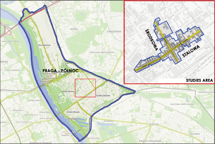
ister of Monuments from 2020 and 2021 [2], [3] (Fig. 1).
The state of research
The history of Praga as one of the oldest districts of right-
bank Warsaw has often been the subject of numerous War -
saw studies. Researchers’ attention, however, focused
mainly on the oldest history of the former town, today one
of Warsaw’s districts, while much less attention was paid
2
The decision to undertake conservation proceedings was, to some
extent, determined by the “Streets of Nowa Praga” architectural com-
petition conducted in 2021, the winning design of which assumed the
transformation of Średnia Street into the so-called woonerf.
DOI: 10.37190/arc230304
Published in open access. CC BY NC ND license
40 Iwona Krawiec
to the history of its younger parts, such as Nowa Praga or
Szmulowizna.
One of the rst and most extensive mentions of Nowa
Praga appeared in the 9
th
volume of the Słownikgeogra
cznyKrólestwaPolskiego[Geographical Dictionary of
King dom of Poland] [4], published in 1888, which con-
tained quite detailed information about the history of the
establishment of subsequent parts of the Nowa Praga settle-
ment and the state of development in this area in the 1880s
century, i.e. before it was incorporated into the capital.
However, the lion’s share of the description was not devot-
ed to residential buildings, but to industry and steelworks,
the construction of which had a signicant impact on the
development of the suburb at the end of the 19
th
century.
Another collective study containing information about
the researched area is the pre-war DziejePragiwarsza
wskiej od czasów najdawniejszych do obecnych [History
of Praga in Warsaw from the earliest times to the present]
by Władysław Wójtowicz [5], in which the author – like
his predecessors – described the entire district, and devot-
ed only a small part of the publication to the buildings of
Nowa Praga, repeating the information presented in the
Słownikgeograczny… [4].
After World War II, interest in Warsaw’s Praga as a re-
search area increased signicantly. Further studies began
to appear, including a collective work edited by Józef Ka-
zimierski et al., DziejePragi[History of Praga], in which
a group of authors addressed both architectural and urban
issues as well as socio-economic questions, constantly
limiting themselves to looking at the contemporary dis-
trict as a whole [6].
In addition to scientic studies, various guides and
popular science publications have been published over
the years. These include the above-mentioned study by
the journalist and expert on Warsaw Kasprzycki Korzenie
mia sta, in which the author discussed selected facts and
curiosities regarding the history of further streets in Pra-
ga, including Stalowa and Średnia [1].
Michał Pilich is currently the leading voice among the
researchers dealing with the history of Praga. He has au-
thored articles and monographs devoted to Praga, includ-
ing the book titled UliceNowejPragi[Streets of Nowa
Praga], in which he was the rst to deal specically with
this area of Warsaw [7], but without a comprehensive
look at the urban planning and architecture of the former
suburb.
In the rather extensive literature on the subject, no
one has yet attempted to take a comprehensive look at
the spatial and architectural changes in Nowa Praga, so
it seems reasonable to carefully analyse at least a fraction
of this part of Warsaw. In this context, the buildings situ-
ated along the above-mentioned most signicant streets in
Nowa Praga should be considered as the most represen-
tative area.
Research method
During the research, the collected source material was
analysed and compared, juxtaposed with the information
contained in previous studies, and drawings of subsequent
stages of urban and architectural transformations were
created on its basis (development of subsequent parts
of Nowa Praga, construction and reconstruction of new
buildings and demolition of old ones).
Many source materials have been preserved to this day,
including maps, photographs and drawings, as well as pre-
war press releases. The most helpful cartographic materi-
als include map collections made in Lindley’s workshop
in the years 1883–1915 [8] and materials created by the
Biuro Odbudowy Stolicy (BOS). Moreover, most of the
buildings along both streets were photographed in 1979
and are kept in the Archives of the Masovian Provincial
Monument Conservator Oce and constitute a valuable
source of information. A similarly large collection of ar-
chival photographs of Nowa Praga buildings is in the col-
lection of the National Digital Archives (NAC).
Fig. 1. Location of the studied
area against the background
of the Praga-Północ district
(elaborated by I. Krawiec)
Il. 1. Lokalizacja badanego
obszaru na tle dzielnicy
Praga-Północ
(oprac. I. Krawiec)
AnalysisofspatialtransformationsanddevelopmentofthemainstreetsofthehistoricNowaPragadistrictinWarsaw 41
The history of transformations
of the urban layout of Nowa Praga
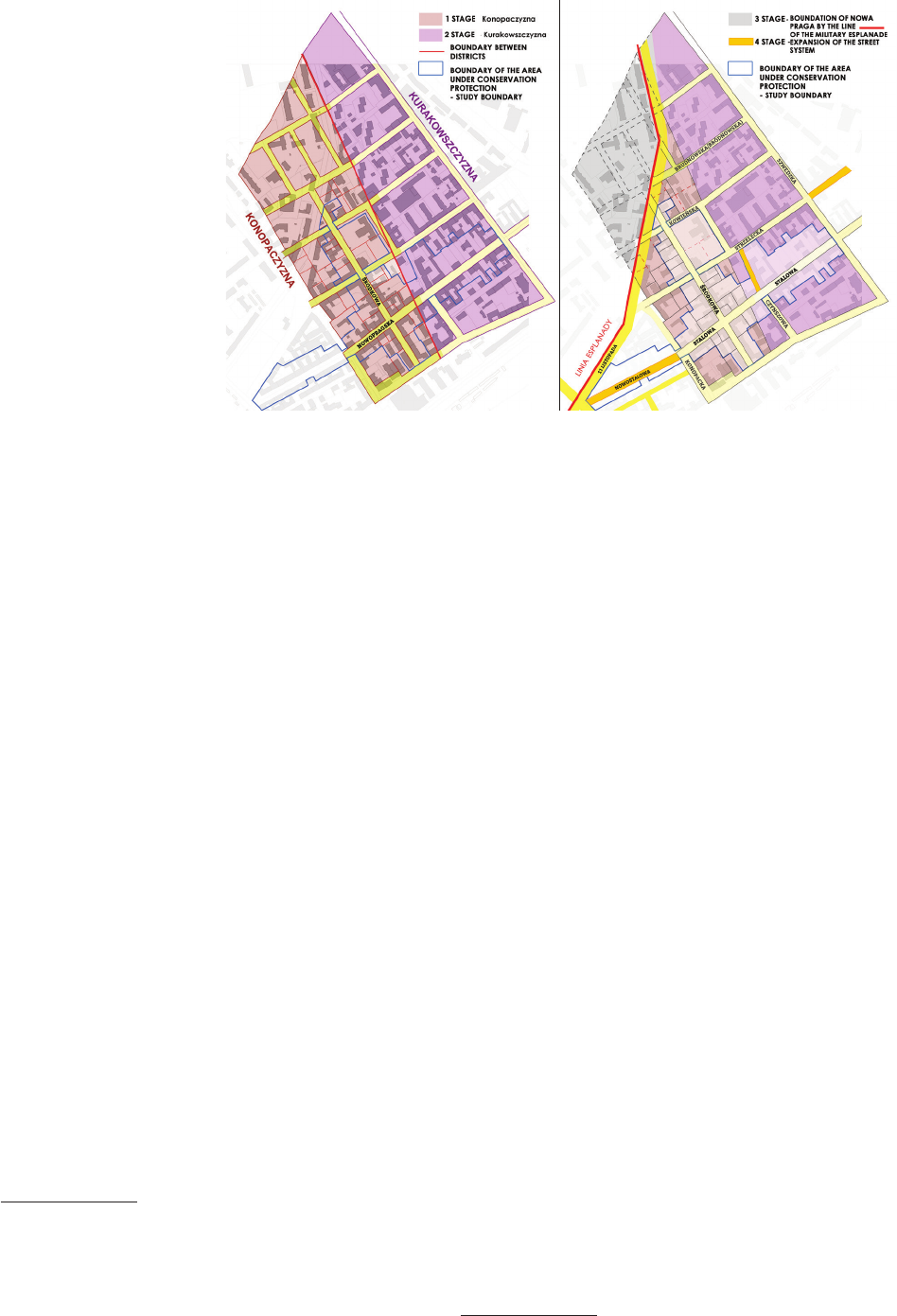
Konopaczyzna
The spatial development of this part of Warsaw be-
gan in 1844, when the surrounding land belonging to the
Targówek manor
3
, owned by Józef Nosowski, was divid-
ed into several colonies. Two of them were purchased by
Ksawery Konopacki and Joachim Kurakowski [4], [7]. In
1857, Ksawery Konopacki purchased the colony number
12, covering 12morgensand12rods[old units of land
area] [4, p. 16], and then began parcelling and selling the
purchased land. He probably predicted the development of
Warsaw and the increase in land prices east and northeast
of Praga
4
. In 1861, surveyor Ludwik Sikorski prepared, at
Konopacki’s request, a regulatory plan for the estate, which
was nally approved by the Russian authorities in 1865.
The plan assumed dividing the trapezoidal-shaped area
into about 100 plots. The rst street routes were marked
out, and the main one was Środkowa Street running north-
-south [7]. Outside it, a network of streets was designed,
most of which have not changed their course to this day.
The main artery streets were marked out: Strzelecka,
Brudnowska (now Bródnowska), Kościelna (now Ko-
wień ska), Wileńska and Nowopragska, which was later
renamed Stalowa, as well as several streets located north
of Średnia Street. The plan of the completed colony was
published in one of the issues of “Tygodnik Ilustrowany”
on January 26, 1867
5
.
3
The areas of today’s Nowa Praga, Targówek Michałowa, Indus-
trial and Residential Targówek, Szmulowizna.
4
The current Old Praga, already part of Warsaw, incorporated into
the capital in 1794.
5
Additionally, two versions of the Konopaczyzna plan have been
preserved. The oldest of them, dating from 1863, is included in the col-
lection of mortgage book documents, ref. no. 220 in the State Archives
of the Capital City of Warsaw.
The rst stage of the new settlement was built on unde-
veloped land located between Stara Praga [Old Praga] in the
west and the sandy dunes of Targówek in the east, which
made it possible to use a simple, orthogonal street layout.
The development of the new suburb was undoubtedly posi-
tively inuenced by the proximity of the newly built railway
line to the Petersburg Train Station at Wileńska Street, which
constitutes the southern border of the colony (Fig. 2a).
Kurakowszczyzna
The initial low price of the land sold by Konopacki
6
[4] caused great interest in purchasing a plot in the new
settlement, and just a few years after the establishment of
Konopaczyzna, the new development began to extend be-
yond its original boundaries. From the areas neighbouring
it to the east, the so-called Kurakowszczyzna region, was
named after the new owner – Joachim Kurakowski [2],
[3], [9]. It was planned on the basis of the existing street
network of Konopaczyzna. On maps of Warsaw from the
1860s, it can be seen that the mentioned streets extend
from the east beyond the border of Konopacki’s estate.
As “Tygodnik Ilustrowany” reported in 1867, buildings
numbering about 30 houses began to be built in the new
areas along the streets [10]. Despite the changes that have
taken place in Nowa Praga since then, the old, diagonal
borderline between the Konopaczyzna and the Kurakow-
szczyzna region is still visible in the ownership division
(Fig. 2a).
Esplanade
The next stage of the spatial transformation of the set-
tlement was related to the Śliwicki fort, built in 1835–
1838 in the Golędzinów area. An esplanade was marked
6
At rst, one cubit cost 20 kopecks, and around 1880 the price
increased to 2 rubles per cubit.
Fig. 2. Reconstructions of
the planning phases of Nowa Praga:
a) the first (Konopaczyzna) and
the second (Kurakowszczyzna),
b) third (limited to military
esplanade) and fourth (further
development of buildings)
(elaborated by I. Krawiec)
Il. 2. Rekonstrukcje faz
rozplanowania Nowej Pragi:
a) pierwszej (Konopaczyzny)
i drugiej (Kurakowszczyzny),
b) trzeciej (ograniczenie wojskową
esplanadą) i czwartej
(dalszy rozwój zabudowy)
(oprac. I. Krawiec)
a b
42 Iwona Krawiec
in front of the fort, the initial width of which was 850 m
(later it was widened to 1,300 m) [11]. Due to the cre-
ation of a free zone surrounding the fort, the development
possibilities of the emerging suburb were signicantly
limited. In 1875, part of the area of Nowa Praga became
part of its borders and was purchased by the Board of the
Warsaw Military District. The existing buildings on the
purchased land were demolished and the construction of
military infrastructure began: barracks complexes, provi-
sion plants and warehouses [2], [3]. The buildings in the
northern part of the settlement were liquidated, including:
Boczna, Nowa, Grodzka and Stolarska streets, as well
as several properties on Średnia Street, from the north
(Fig. 2b). The border of the designated at the time military
esplanade became today’s 11 Listopada Street – previous-
ly called Esplanadowa and Śliwicka Streets (in parts).
Further development
Although, as a result of the expansion of the forti-
cations of the Warsaw Fortress, some of the buildings in
Nowa Praga were demolished and the area of the settlement
was signicantly reduced, the young suburb did not stop
developing. In 1878 in its eastern part, behind the line of to-
day’s Szwedzka Street, the construction of a factory by the
Warsaw Steel Factory Joint Stock Company began. It op-
erated for a relatively short time and was nally closed in
1889, but its creation was a strong impulse for the develop-
ment of the suburb [2]–[4]. The location of the plant in the
district increased the importance of Stalowa Street, which
became the main communication artery of the suburb.
A breakthrough for Nowa Praga was the year 1891,
when, together with the areas of Szmulowizna, it became
one of the districts of Warsaw. The discussion on incor-
porating it into the city boundaries began much earlier,
but due to the need to spend large amounts of money on
organizing and maintaining the new district, the decision
to create it was postponed [4]. When it was undertaken,
streets were regulated, sidewalks were separated, roads
were paved, and lighting and urban transport in the form
of a horse-drawn tram were introduced. The mortgage
numbering of plots was also adjusted to the system used
in the capital [2], [3].
When Nowa Praga was incorporated into the capi-
tal, Stalowa Street acquired its current name. Over time,
a new section of the artery was marked out, extending it
westwards (up to the esplanade line), which was named
Nowostalowa Street
7
. The street has retained its length
to this day. The last modication of the street network
was introduced a few years ago during the construction
of one of the multi-family buildings (Stalowa 39), when
Czynszowa Street was extended towards Strzelecka Street.
Its irregular course is a relic of the former border between
the oldest parts of the site (Fig. 2b).
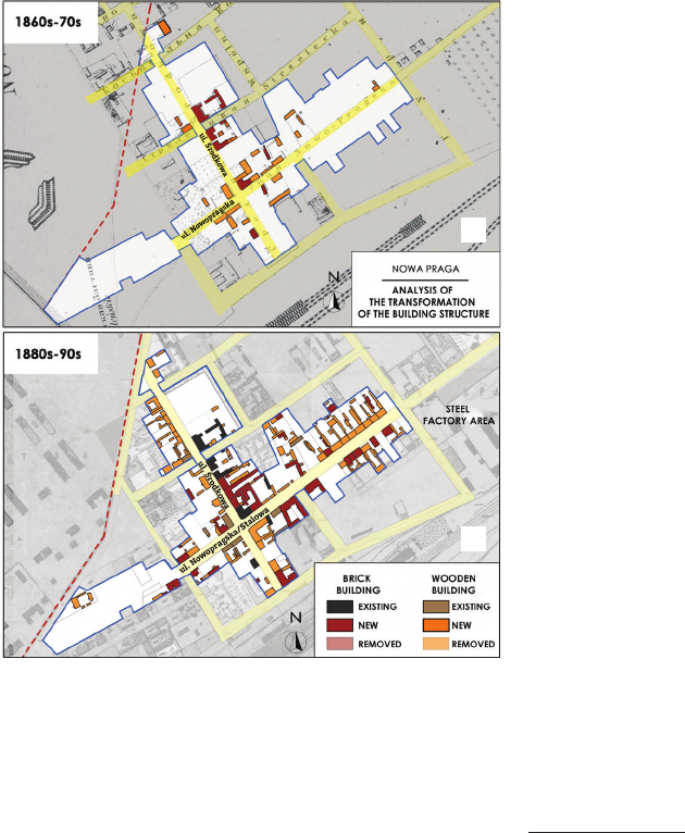
History of architectural transformations
A multi-phase reconstruction of the development of
buildings in the studied area, which maintained the divi-
sion into wooden and brick buildings was made, based on
the collected cartographic and iconographic material.
In the rst years of the Konopaczyzna’s existence,
mainly wooden buildings were built on parcelled plots
[4]. Brick buildings appeared sporadically at the intersec-
tions of main streets (Fig. 3a). The Ksawery Konopacki
Palace, preserved to this day, dates back to the rst peri-
od of Nowa Praga, built between 1861 and 1866. It was
the rst brick building in this part of Praga, hence, due
to its magnicence and decorative character compared to
neighbouring buildings, it was commonly called a palace.
Maria Galeotti’s tenement house, standing at the corner
of Strzelecka and Średnia Streets, and the buildings on
the eastern side of Średnia Street, between Strzelecka and
Stalowa Streets (Środkowa 12, 14, 16, 18) [3], have also
survived to this day, although in a changed form.
After the steelworks were established
The dynamics of the street’s development were un-
doubtedly inuenced by the opening of a steelworks in
1879, which became a workplace for a huge number of
workers. At the beginning, it employed 896 employees
7
Around 1920, it was ocially attached to Stalowa Street.
Fig. 3. Reconstruction of the building system:
a) in the first years of the existence of Nowa Praga,
b) during the lifetime of the steel factory
(elaborated by I. Krawiec based on [12], [13])
Il. 3. Rekonstrukcje układu zabudowy:
a) w pierwszych latach istnienia Nowej Pragi,
b) w okresie istnienia stalowni
(oprac. I. Krawiec na podstawie [12], [13])
a
b
AnalysisofspatialtransformationsanddevelopmentofthemainstreetsofthehistoricNowaPragadistrictinWarsaw 43
(including 330 foreigners), and a year later it employed
1,037 people (114 foreigners). At its peak, the factory
employed over 1,100 people, making it one of the largest
industrial plants in the agglomeration [4].
In the 1880s, there was a sharp increase in construction
activity in the suburb, due to the proximity of a prosperous
factory whose employees needed a permanent place of
residence located close to the steelworks. Although mainly
multi-family brick houses were built at that time, the char-
acteristic wooden houses still dominated the landscape of
Nowa Praga (Fig. 3b). Most of them housed workers of
the steelworks and the Warsaw–Petersburg Railway, and
the brick buildings were inhabited by the owners of near-
by factories and production plants and the middle class.
According to statistical data, in 1888 there were 253
buildings in Nowa Praga and 17 houses in the area be-
longing to the factory. The population was 4,211 people
(excluding migrant workers who were not included in the
permanent population records) [4]. At that time, a number
of brick one- and two-story tenement houses were built
(currently Stalowa 21, 28/30, 33). Some of the buildings
for which a building permit was issued were never built
or were later demolished (including the current Stalowa
29, 37, 39, 47).
The closure of the plant after only a decade of opera-
tion
8
and the numerous res that in the 1880s and 1890s
consumed the houses of Nowa Praga (a.o. in 1880 and
1893) [2], did not stop further development of the district
and in the last decade of the 19
th
century it was enriched by
further tenement houses (today Stalowa 14, 25, 34, 52, 54).
Despite the visible change in construction trends,
wooden houses were still willingly built in a layout typ-
ical of brick tenement houses (front building and side
annexes). At that time, a series of buildings was built on
Stalowa Street on the section between Czynszowa and
Szwedzka Streets (mainly on the northern side), as well
as along Średnia Street (on the entire length – mainly be-
tween Strzelecka and Kowieńska Streets).
The single-story house located at 9 Średnia Street is
the only witness to the times of wooden Nowa Praga that
has survived to this day. It was most likely built in the
1870s or 1880s for Elżbieta Sikorska
9
. In the following
years, it housed the seat of the Municipal Court, and in
1933, in the wooden house was located the Society of the
Friends of Street Children created by Kazimierz Lisiecki,
called “Grandpa” by his mentees. The rst people under
the care of the child support facility were small Warsaw
newspaper boys, vagabonds and orphans. In 1952, the
building was taken over by the Polish Red Cross, and the
Society of Friends of Street Children was liquidated [9].
8
The buildings of the former steelworks were taken over by the
Russian Imperial army in 1889 and artillery workshops were located
there, which were transformed into arms workshops in 1918.
9
In the 1860s, Elżbieta Sikorska purchased the property from
Ksawery Konopacki, which included the current addresses: Głosowa 7,
9, 11. There is no agreement as to the date of construction of the build-
ing. Some studies give the year 1869, others 1879. It is certain that the
building existed in this place in the 1890s, because it is marked on the
plans prepared by Lindley’s studio.
In December 1987, the building was entered into the Reg-
istry of Cultural Property. It currently houses the headquar-
ters of the Kazimierz Lisiecki Educational Centers Group,
a division of the Family Support Centre – Family Warsaw.
During this period, the rst modernization works on
the Nowa Praga’s. Both roads were graded and partial-
ly hardened with gravel. The paved paths stood out from
the rest of the streets in Nowa Praga, which were alter-
nately sandy or muddy [4, p. 16]. As reported by “Ku-
rier Warszawski” in 1880, it was Nowopragska Street, not
Środkowa Street (i.e., the original main street of Nowa
Praga), that was modernized rst [14].
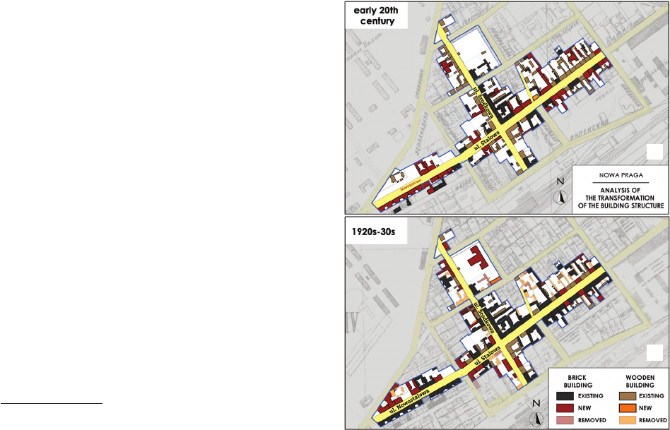
Beginningofthe20
th
century
Despite the huge number of construction investments
undertaken during the operation of the steel plant, a large
part of the plots along Stalowa Street remained undevel-
oped. In addition, the pool of undeveloped properties in-
cludes areas parcelled out along the new section of the
street extended towards the esplanade line (Nowostalowa
Street). The beginning of the 20
th
century was full of fur-
ther construction investments, which led to the gradual
development of vacant plots (Fig. 4a). Mainly three- and
four-story brick tenement houses with richly decorated
facades were built (most of which were deprived of any
Fig. 4. Reconstruction of the building system:
a) at the beginning of the 20
th
century, b) in the interwar period
(elaborated by I. Krawiec based on [13])
Il. 4. Rekonstrukcje układu zabudowy:
a) na początku XX w., b) w dwudziestoleciu międzywojennym
(oprac I. Krawiec na podstawie [13])
a
b
44 Iwona Krawiec
details in the rst years after World War II). These houses
have survived to this day in a modied form (currently
Stalowa 2, 4, 11, 18, 35, 36, 37, 41, 46, 50, 68). At that
time, most of the streets in Nowa Praga were paved
10
, and
a horse tram route was run through Stalowa Street [6], [7].
The interwar period
Although World War I did not directly aect the de-
velopment of the district, it signicantly slowed down
construction processes in Nowa Praga. Even before World
War II, large-scale demolition of wooden buildings began
with the intention of replacing them with brick buildings
(the demolition of annexes and front buildings). During
this time, among others: demolition of wooden buildings
on the corner of Średnia and Strzelecka streets. In most
cases, the cleared plots were built up only after World
War II. The houses built at that time include tenement
houses built at the intersection of Średnia and Kowieńs-
ka Streets, characterized by a modern, modernist form. At
that time, buildings were built at Środkowa 3, 3a, 6, 7, 27,
30. Most of the empty plots on Stalowa Street (mainly
the northern side of the section between Konopacka and
Inżynierska Streets) were built up
11
(Fig. 4b).
In the 1920s, on a large plot of land located at the back
of the Konopacki palace, previously occupied by the wood
yards of the Endelman and Papierny company, a school
building was built, which construction was completed in
10
In 1903, sidewalks made of concrete slabs were made along Sta-
lowa Street.
11
At that time, among others, Zwierzchowski’s tenement house at
number 47, designed by R. Ostoja-Chodkowski, the building at Stalowa
38, designed by J. Kranc, and the tenement house complex of E. Horn-
stein at Stalowa 3/5.
1935. In 1934, three primary schools, previously located
in small rooms that were not conducive to teaching, were
moved to an unnished building on Kowelska Street [15].
In the interwar period, Nowa Praga gradually changed
its character. From a typical suburb built with low wood-
en houses, loosely spaced, it was changing into a densely
built-up district with a metropolitan character – not signi-
cantly dierent from the development of left-bank Warsaw.
The period of World War II
According to data prepared by the “Biuro Odbudowy
Stolicy”, as a result of the war activities conducted in
1939–1945, as many as 84% of Warsaw’s buildings were
destroyed. Although a large part of Praga’s buildings were
wooden and therefore ammable, in Praga this percentage
was only 25%. In the analysed area, only a few objects
were destroyed or damaged (e.g., roof burning). These
were mainly outbuildings and farm buildings.
1945–1990s
The historic buildings of Środkowa and Stalowa
Streets survived World War II without signicant dam-
age, and their major transformations took place only after
1945. Some of the tenement houses were taken over by
the State Treasury and, as a result of administrative deci-
sions, deprived of their architectural decorations. Some of
the disgured tenement houses were plastered smoothly
and painted (including Stalowa 24 and 28/30). Some of
the buildings with fragmented architectural details were
left in this form without any protection against further de-
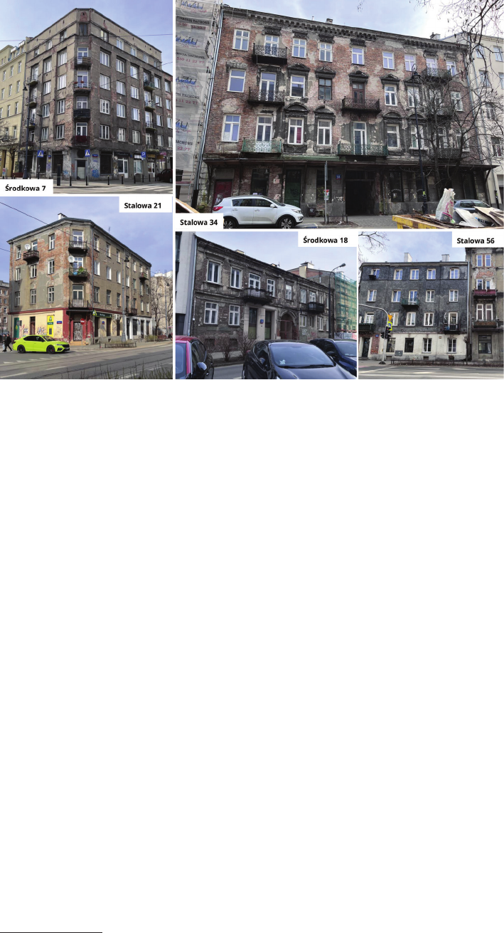
struction (Stalowa 34, 54, 56) (Fig. 5).
The 2
nd
half of the 20
th
century was primarily a peri-
od of disappearance from the landscape of the district of
Fig. 5. Tenement houses
at Stalowa Street and
Środkowa Street stripped
of architectural decoration
after World War II
(photo by I. Krawiec)
Il. 5. Kamienice przy ul. Stalowej
i Środkowej ogołocone
z dekoracji architektonicznej
po II wojnie światowej
(fot. I. Krawiec)
AnalysisofspatialtransformationsanddevelopmentofthemainstreetsofthehistoricNowaPragadistrictinWarsaw 45
wooden buildings built in the 2
nd
half of the 19
th
century
(Fig. 6a). Some of it was deliberately demolished with the
intention of building new brick houses in its place, but
most of it fell apart on its own due to the lack of ongo-
ing maintenance and routine renovation works (including
Stalowa 23, 24, 43, 55, 57 and Średnia 19 and 21). In the
1960s, the streets of Nowa Praga were also modernized.
The pavement was replaced or covered with asphalt, and
the gas lighting was replaced with electric uorescent
lamps [2], [7], [9].
1990sandearly21
st
century
The end of the 20
th
century was the nal end of the
wooden Nowa Praga. The last wooden outbuildings (in-
cluding Stalowa 44, 54, 55, 56, 57) have disappeared from
the landscape. Some of the plots, deserted after the slow
disintegration of the wooden houses, were developed with
new multi-family buildings, matching the architectur-
al character of the district in scale, but not in form. The
most striking example of the investments carried out at
that time is a multi-family block, which was built in the
very heart of the district, at the intersection of Stalowa
and Średnia streets (Stalowa 26). It was built on the site
of a two-story wooden house demolished in the 2
nd
half
of the 20
th
century. The wooden building had an accent in
the form of a one-story increase and a cut corner typical
of Nowa Praga buildings standing at the intersection of
streets. Although the new building was adjusted in height
to the neighbouring tenement houses, the corner was not
emphasized in any way (Fig. 6b).
21
st
century
The investment stagnation at the end of the millennium
extended into the rst years of the next century. The situ-
ation changed in the 2
nd
and 3
rd
decades of the 21
st
cen-
tury, when the great potential of the areas located on the
left bank of the Vistula was noticed. Previously, for many
years this district had a reputation for being worse and
poorer, which was partly due to the post-war resettlement
of lower social classes from representative districts to Pra-
ga. This way of thinking about Praga is gradually chang-
ing, and the district itself is regaining its former glory.
The approach to the architectural monuments of Nowa
Praga has also improved. In recent years, many renova-
tions of historic buildings have been carried out, mainly
tenement houses, but also public buildings. It regained
its former glory, among others the previously mentioned
Konopacki Palace, which was in a disastrous condition
and was saved from demolition only by its entry into the
Registry of Cultural Property in 2005 and thorough revi-
talization in 2017–2021. Currently, the former residence of
the district’s founder houses the TuPraga Cultural Centre.
It is also worth mentioning the revitalization carried out
in recent years of the last relic of the 19
th
-century wooden
architecture in Nowa Praga – the seat of the Complex of
Educational Centers. Kazimierz Lisiecki “Grandfather”.
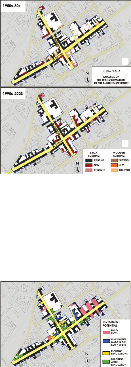
A total of 16 general renovations have been carried out
in recent years, and two more are planned for the coming
years (Średnia 12 and Stalowa 25). In recent years, new
multi-family houses have also been built on plots at Sta-
lowa 27, 39 and Północna 20. A multi-family building at
Stalowa 42 is also under construction (Fig. 7). Moreover,
Fig. 6. Reconstruction of the building system:
a) in the 2
nd
half of the 20
th
century,
b) at the turn of the 20
th
and 21
st
centuries
(oprac. I. Krawiec na podstawie [16])
Il. 6. Rekonstrukcje układu zabudowy:
a) w 2. połowie XX w., b) na przełomie XX i XXI w.
(elaborated by I. Krawiec based on [16])
a
b
Fig. 7. Plan of the analysed area with the designation of
the renovated objects, the latest construction projects and empty plots
(elaborated by I. Krawiec)
Il. 7. Plan analizowanego obszaru z oznaczeniem obiektów
wyremontowanych, najnowszych inwestycji budowlanych
oraz pustych działek (oprac. I. Krawiec)
46 Iwona Krawiec
in 2021–2022, the street was thoroughly modernized Sta-
lowa Street. The surface of the sidewalks and the roadway
was tidied up, the issue of parking along the street was
regulated, lighting was standardized, small architecture
in the form of benches, garbage bins and low fences was
introduced, and new plantings were made along the road.
Analysis of the current state of development
–architectureandurbanplanning
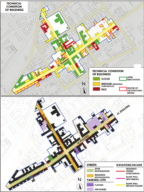
For the purposes of the analysis, a general assessment
of the technical condition of objects in the area covered
by the study was also performed (Fig. 8a). Even though
a signicant part of the tenement houses has undergone
thorough renovation, the overall condition of the area’s
buildings was assessed as average. A large part of the
buildings deprived of architectural decoration after the
World War II have not been restored to this day, although
fragments of cornices, window and door openings or bon-
ing have been preserved on the basis of which they could
be reconstructed (e.g., Stalowa 34). Some of them, due
to their very poor technical condition, require immediate
conservation intervention, as there is a risk of sudden col-
lapse of part or the entire facility (Średnia 18) (Fig. 5).
Although the original buildings of Nowa Praga were
almost completely replaced over the course of almost two
centuries, the urban layout of the streets marked out by
the surveyor L. Sikorski and continued during the parcel-
ling out of the Kurakowszczyzna region was not signi-
cantly deformed. It was only developed by extending the
Czynszowa Street up to the height of Strzelecka Street.
To this day, the former border between Konopaczyzna
and Kurakowszczyzna, running diagonally, is also visible,
preserved in the demarcation line between the properties
of Stalowa 26 and 28 and 35 and 37 (Fig. 2).
The biggest urban problems aecting the studied area
are empty plots that are the remains of demolished wooden
houses. It mainly concerns the property at Stalowa Street
on the section between Czynszowa Street and Szwedz-
ka Street. Undeveloped since the 1970s and 1980s, they
were gradually occupied by wild parking lots, unplanned
greenery and numerous illegally built sheds and annexes.
The lack blurs the perception of the street frontage, which,
combined with the omnipresent parked cars, creates spa-
tial chaos. The blind walls, which still have traces of the
non-existent buildings, discourage passers-by and tourists.
Only some of the gable walls of the tenement houses were
beautied with murals (Średnia 17, Stalowa 38) or climb-
ing greenery (Fig. 8b).
Undoubtedly, a necessary measure aimed at restoring
spatial order would be to erect new buildings in place of
non-existent timber, so as to restore the line of the front-
age of the street. The scale and dimensions of the build-
ings should correspond and harmonize with the existing
buildings (widths of fronts, number of oors, spacing of
window axes). In addition, Środkowa Street should un-
dergo revitalization, similarly to what was carried out on
Stalowa Street in recent years, with emphasis placed on
maintaining the urban character of the artery as the main
street of New Praga.
Conclusions and summary
Based on the analyses carried out, it should be stat-
ed that within 162 years the architectural character of
the district changed from suburban to metropolitan, and
within only 100 years virtually all of the district’s wood-
en buildings were replaced (Fig. 9). Its scale has changed
– single-story and double-story houses have been replaced
by multi-story tenement houses. Despite numerous mod-
ications, the historical division of land and ownership
from subsequent stages of the district’s development is
still clearly visible. The development in Nowa Praga is an
interesting example of shaping the urban fabric of Warsaw.
The preserved architectural structures that build the char-
acter of the district are interesting examples of the evolu-
tion of the development of tenement buildings through out
the 19
th
and 20
th
centuries.
Undoubtedly, valuable elements include the preserved
complex of buildings built in the rst years of the settle-
ment’s existence, representing the early phase of devel-
opment in Praga. The largest group of buildings are ten-
ement houses from the turn of the 19
th
and 20
th
centuries
and the beginning of the 20
th
century with original, richly
Fig. 8. Plans of the survey area including:
a) analysis of the technical condition of buildings,
b) crisis areas requiring intervention
(elaborated by I. Krawiec)
Il. 8. Plany badanego obszaru obejmujące:
a) analizę stanu technicznego budynków,
b) przestrzenie kryzysowe wymagające interwencji
(oprac. I. Krawiec)
a
b
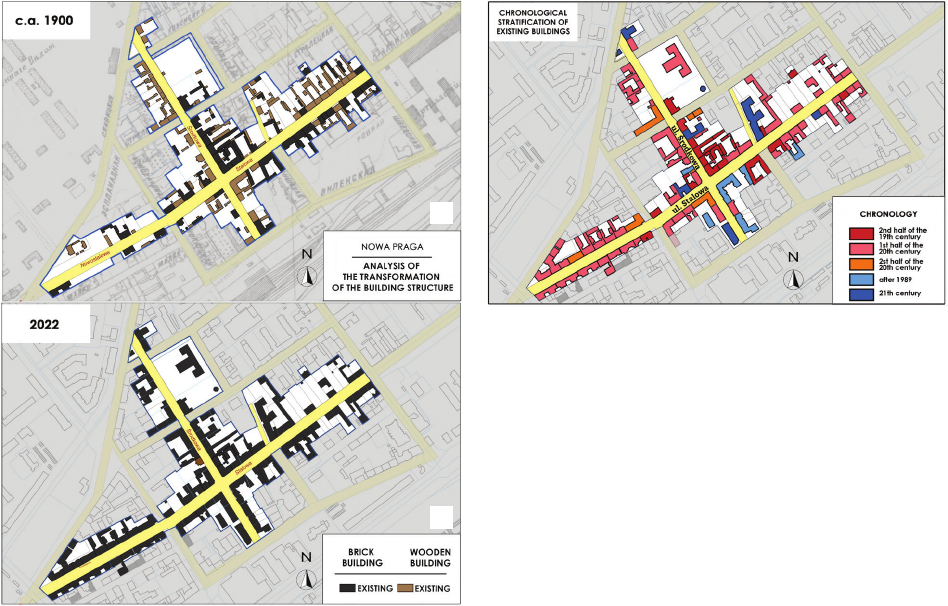
AnalysisofspatialtransformationsanddevelopmentofthemainstreetsofthehistoricNowaPragadistrictinWarsaw 47
decorated façades. They are adjacent to tenement hous-
es from the interwar period, with simplied details and
modern functional solutions (Fig. 10). A relatively small
percentage of buildings were built after 1945.
Compared to the district, the area of the former Nowa
Praga is distinguished by a relatively regular, orthogonal
grid of streets, surrounded by harmonious tenement hous-
es. Also noteworthy is the arched course of 11 Listopada
Street, which is a carrier of information about the former
military line of the esplanade of Fort Śliwicki. Even to-
day, it constitutes a visible border between the areas of the
district in question and the former areas purchased by the
Warsaw Military District Board and the built-up military
infrastructure facilities.
The reconstruction plans and analyses prepared as part
of the research illustrate not only the subsequent phases
of the district’s reconstruction but also show the intensi-
ty of the pace at which right-bank Warsaw was develop-
ing at the turn of the 19
th
and 20
th
centuries, which, had
it not been for the turmoil associated with World War II
and post-war changes, political and political system, could
quickly match the grandeur and splendour of left-bank
Warsaw.
As part of the work described above, only a part of the
Nowa Praga complex was analysed. It seems reasonable
to continue the research and supplement it with the re-
maining quarters and the areas of the former steelworks.
Nowa Praga, which has been building its identity for
over 160 years, although it survived both world wars un-
scathed, was signicantly disgured and neglected in the
2
nd
half of the 20
th
century. It is only in recent years that
the potential of Nowa Praga’s monuments has begun to be
recognized and treated as a valuable element of the city’s
cultural heritage, worth protecting and preserving for fu-
ture generations. The tenement houses, which have exist-
ed for over 100 years, are a living document and carrier of
the atmosphere of old, pre-war Warsaw, and the preserved
street layout contains information about the past of this
part of the city.
Translated by
Iwona Krawiec
Fig. 9. Reconstruction of the building system:
a) in the 2
nd
half of the 20
th
century,
b) at the turn of the 20
th
and 21
st
centuries
(elaborated by I. Krawiec based on [16], [17])
Il. 9. Rekonstrukcje układu zabudowy:
a) w 2. połowie XX w., b) na przełomie XX i XXI w.
(oprac. I. Krawiec na podstawie [16], [17])
Fig. 10. Chronological stratification of existing buildings
in the studied area
(elaborated by I. Krawiec)
Il. 10. Rozwarstwienie chronologiczne istniejącej
na badanym obszarze zabudowy
(oprac. I. Krawiec)
a
b
Acknowledgement
ResearchnancedbytheRNDinternal grantoftheFacultyofArchi
tectureoftheWarsawUniversityofTechnologytosupportscienticre
searchinthedisciplineofArchitectureandUrbanPlanningin2023.
48 Iwona Krawiec
Abstract
Analysis of spatial transformations and development of the main streets of the historic Nowa Praga district in Warsaw
The subject of the article is the spatial and architectural development of Nowa Praga [New Praga], located in the Praga-Północ [Praga-North]
district of Warsaw, which dates back to the 1
st
half of the 19
th
century. On the then undeveloped land, a network of streets was laid out, among which
the main ones were Środkowa Street and then Nowopragska (now Stalowa Street).
The aim of the research presented in the article was to trace the transformations that took place in the urban planning and architecture of Nowa
Praga during the nearly 200 years of its existence, as well as to analyse the current state of development and urban layout and draw conclusions for
the future. For the purposes of the research, extensive cartographic and iconographic material was collected and analysed, which served as the basis
for developing subsequent phases of the development of the studied area. The result of the work are reconstruction drawings presenting subsequent
stages of the spatial development of the studied area, as well as chronological stratication of the existing buildings, an analysis of their technical
condition and a denition of the main problems aecting the studied spatial development.
Based on the analyses carried out, it should be stated that in just 100 years, the architectural character of the district has changed drastically, but de-
spite numerous modications, the historical division of land and ownership from subsequent stages of the district’s development is still clearly visible.
Key words: 19
th
and 20
th
centuries, Nowa Praga, urban and architectural transformations, Stalowa Street, Środkowa Street
Streszczenie
Analiza przekształceń przestrzennych i zabudowy głównych ulic historycznej warszawskiej Nowej Pragi
Tematem artykułu jest rozwój przestrzenny i architektoniczny Nowej Pragi, leżącej na terenie dzielnicy Praga-Północ w Warszawie. Jej początki
sięgają 1. połowy XIX w. Na niezagospodarowanych wówczas gruntach wytyczona została sieć ulic, wśród których głównymi stały się ul. Środko-
wa i ówczesna Nowopragska (obecna ul. Stalowa). Celem badań przedstawionych w artykule było prześledzenie zmian, jakie zaszły w urbanistyce
i architekturze Nowej Pragi na przestrzeni blisko 200 lat jej istnienia, a także analiza obecnego stanu zabudowy i układu urbanistycznego oraz wy-
ciągnięcie wniosków na przyszłość.
Na potrzeby badań zgromadzony i przeanalizowany został obszerny materiał kartograczny i ikonograczny, który posłużył jako podstawa do
opracowania kolejnych faz rozwoju badanego obszaru. Efektem prac są rysunki rekonstrukcyjne przedstawiające kolejne etapy rozwoju przestrzen-
nego, a także rozwarstwienie chronologiczne istniejącej zabudowy, analizy jej stanu technicznego oraz denicja głównych problemów dotykających
badane założenie przestrzenne.
Na podstawie przeprowadzonych analiz należy stwierdzić, że w przeciągu zaledwie 100 lat charakter architektoniczny dzielnicy zmienił się
drastycznie, jednak mimo licznych modykacji ciągle czytelny jest historyczny podział parcelacyjny i własnościowy z kolejnych etapów rozwoju
dzielnicy.
Słowa kluczowe: XIX i XX w., Nowa Praga, przekształcenia urbanistyczne i architektoniczne, ul. Stalowa, ul. Środkowa
[1] Kasprzycki J., Korzeniemiasta.Warszawskiepożegnania, t. 3, Pra
ga, Wydawnictwo VEDA, Warszawa 1998.
[2] DecyzjaMWKZnr40/2021zdn.24.03.21dotyczącawpisaniadoRe
jestruZabytkówhistorycznegoukładuurbanistycznegoul.Stalowej,
https://bip.mwkz.pl/uploads/images/obwieszczenia/2021.03.30/Sta-
lowa%20decyzja%20PDF.pdf [accessed: 10.02.2023].
[3]
DecyzjaMWKZnr69/2020zdn.26.08.20dotyczącawpisaniadoRe
jestru Zabytków historycznego układu urbanistycznego ul. Środko
wej, https://bip.mwkz.pl/uploads/images/obwieszczenia/2020.08.28/
5140.1.15.2020_Warszawa_Srodkowa_zal_urbanistyczne_dec.69.pdf
[accessed: 10.02.2023].
[4] SłownikgeogracznyKrólestwaPolskiegoiinnychkrajówsłowiań
skich, t. 9, nakł. F. Sulimierskiego i W. Walewskiego, Warszawa
1888, 16–17.
[5] Wójtowicz W.J., DziejePragiwarszawskiejodczasównajdawniej
szych do obecnych, Wydawnictwo Głos Pragi, Warszawa 1934.
[6] Dzieje Pragi, J. Kazimierski, R. Kołodziejczyk, Ż. Kormanowa,
H. Rostkowska (red.), PWN, Warszawa 1970.
[7] Pilich M., UliceNowejPragi, Fundacja Wspierania Kultury VEDA,
Warszawa 2003.
[8] Atlas historyczny Warszawy, t. 1, A. Jankiewicz, P.E. Weszpiński,
M. Witecki (red.), Miasto Stołeczne Warszawa, Archiwum Państwo-
we m.st. Warszawy, Wojewoda Mazowiecki, Warszawa 1999.
[9] Pilich M.,TajemniceNowejPragi.Stalowa39, Go-Local, Warszawa
2018.
[10] NowaPragapodWarszawą, “Tygodnik Ilustrowany” 1867, nr 383,
26.01.1867, 40–41.
[11] Miniewicz J., Znaczenie militarne Pragi, [in:] A. Sołtan (red.),
Warszawskiej Pragi dziejedawneinowsze, Wydawnictwo Jeden
Świat, Warszawa 2006, 203–227.
[12] PlanmiastaWarszawyiokolicz1867, http://mbc.cyfrowemazow-
sze.pl/dlibra/docmetadata?id=2357&from=publication [accessed:
12.05.2023].
[13] Plany Warszawy Lindleya 1883–1915, https://mapa.um.warsza-
wa.pl/mapaApp1/mapa?service=mapa_historyczna&L=pl&X-
=7502805.127594725&Y=5788955.369500488&S=2&O=0
&T=0&komunikat=o [accessed: 12.05.2023].
[14] NowaPraga,TargówekiSzmulowizna, “Kurier Warszawski” 1880,
nr 210, 10.09.1880, 1–2.
[15] Gałecki Z., Informator – przewodnik po Warszawie z najnowszym
opisem ulic Wielkiej Warszawy, Wydawnictwo Koła Kulturalno-
Oświatowego Policji Państwowej, Warszawa 1933.
[16] PlaninwentaryzacjizniszczeńWarszawyBiuraOdbudowyStolicy
z lat 1945–1946, https://mapa.um.warszawa.pl/mapaApp1/mapa?-
service=mapa_historyczna&L=pl&X=7502805.127594725&Y=5
788955.369500488&S=2&O=0&T=0&komunikat=o [accessed:
12.05.2023].
[17] Archival aerial and satellite photos from 1945–2022, http://mapa.
um.warszawa.pl/mapaApp1/mapa?service=mapa_historyczna [ac-
cessed: 12.05.2023].
References