
2024
1(77)
Maria Legut-Pintal*, Mikołaj Grosel**
Assessment of the residential space of a pre-industrial city.
The example of Wrocław/Breslau in the 16
th
and 18
th
centuries
Introduction
The urban space is a changing over time and hetero-
geneous structure shaped by its inhabitants, while at the
same time exerting an inuence on the community living
there [1], [2]. The zoning of urban space began with the
formation of urban structures and the dynamics of change
depended on the growth rate of the centre. In the course
of the city’s growth, prestigious as well as degraded areas,
inhabited by a poorer population, emerged within the city.
The problems of social inequality are an aspect frequently
addressed in the current economic literature, also concern-
ing contemporary cities, and are based on dierent meth-
odological approaches [3]. One aspect of inequality is its
DOI: 10.37190/arc240109
Published in open access. CC BY NC ND license
spatial dimension, which is clearly visible in medium and
large cities. It could take dierent scales, from a house
to the neighbourhood. It also had dierent faces, such as
marginalisation, exclusion and gentrication [4], [5].
Social stratication in the pre-industrial city was re-
ected in both material and intangible culture, including
the form of a house. The bourgeois house was considered
an attribute of belonging to an urban community [6].
However, already during the period of the formation of the
charter town in Central Europe, a house was also a tool for
displaying the ambitions and nancial capabilities of the
townsmen. Studies taken by architecture and art historians
often focus on the outstanding and most prestigious ele-
ments, beyond the standard of habitation [7]–[9]. On the
other hand, the results of archaeological research contrib-
ute information about the quality of life in dierent parts
of the city but are often only able to address the architec-
ture and interior design to a limited extent [10]–[12]. Very
rarely is it possible to capture an aggregate picture of the
housing conditions of the entire urban community.
* ORCID: 0000-0001-6406-1038. Faculty of Historical and
Pedagogical Sciences, University of Wrocław, Poland, e-mail:
maria.legut@gmail.com
** ORCID: 0000-0002-0832-876X. Faculty of Architecture,
Wrocław University of Science and Technology, Poland.
Abstract
Social inequalities in cities had their spatial dimension already in pre-industrial times. The quality of living space in a historic city was influenced
by various factors, such as distance from the city centre, proximity to infrastructure, access to water, trade routes, markets, as well as unfavourable
or oppressive neighbourhoods. The value of the properties depended on their function, the structural condition of the buildings, the size of the
structures and the plots.
In this paper, we proposed a method to evaluate and valorise the residential space of a pre-industrial city based on an assessment of its use value.
We carried out an exemplary analysis on the example of Wrocław, a medium-sized city in Central Europe. We used historical, archaeological,
iconographic data and geospatial analyses developed in a geographic information system environment. We carried out the evaluation within
individual factors for a city divided into building blocks for two periods – around 1550 and around 1750.
By comparing the results for these two periods, we attempted to trace the changes that occurred as a result of the city’s development and historical
events. The overall picture allowed us to create a characterisation of residential space across the city. We verified the method by comparing the results
obtained with data from tax records. The result obtained is consistent with knowledge of the spatial distribution of wealth in the city, indicating that
the model can be applied to the analysis of other cities where tax records have not been preserved.
Key words: scoring method, historical geographic information system, housing space
1(77)/2024
74 Maria Legut-Pintal, Mikołaj Grosel
Subject and aim of the research
This paper addresses the problem of validating the
residential space of a historic city on the basis of anal-
ysis of architectural elements and their spatial relations.
The basic assumption adopted in the presented model
is the existence of residential space of various quality
within the city. The dierences in quality are related to
the way space is developed, the distance from the focal
points of the city, the availability of infrastructure and
the presence of positive and negative neighbourhoods.
It was assumed that some elements of urban space in-
crease the value, others decrease it, and some are neutral.
The object of interest is the “non-public” space, built up
with bourgeois houses and their facilities. Public squares
and streets, gardens, cemeteries, as well as religious and
public buildings, manufactures without a residential part
and fortications were excluded from the subject of the
study, however they were treated as elements aecting
the residential space [13].
In the case of positive impacts, there was an ampli-
cation eect – a prestigious building made its immediate
neighbourhood more prestigious and increased its value.
On the other hand, a troublesome neighbourhood – due
to perceived negative aspects, such as noise, unpleasant
smell or “negative symbolic and moral connotations”
– caused a decrease in the comfort of living in the area,
and consequently reduced the value of nearby properties.
This attempt at valorisation is intended to provide
a better understanding of the historic city space, its struc-
ture and the dynamics of change. The study presented
here seeks to identify the zones of the city preferred by
the higher social strata, as well as those necessarily cho-
sen by the poorer.
State of the research
Space valorisation is a tool used today in planning
and management. It is understood as an assessment of
the possibility of a given spatial unit to full a specic
function: residential, agricultural, industrial or recrea-
tional, taking into account selected characteristics of
space [14]. Valorisation methods are also used to assess
the natural values and tourist attractiveness of regions.
So far, spatial valorisation methods have not been used
in historical studies.
Among the valorisation methods used in the assess-
ment of the natural environment and spatial planning is
the scoring method [15]. This method makes it possible
to assign a point value (quantitative) to individual quali-
tative characteristics (diagnostic variables). Summing up
the points for individual features allows for a synthetic
evaluation of a given spatial unit in terms of its attrac-
tiveness, as dened from the research point of view. The
synthetic value may be based on a system of weights
taking into account the value of the dominant factor or it
can be modied in the case of a specic variable.
The theoretical basis of this study is inspired by ele-
ments of the holistic model of real estate appraisal [16].
This model assumes that each heterogeneous good is
characterised by a set of consumer- and producer-rele-
vant characteristics that are relatively homogeneous. It
therefore requires determining which factors were deci-
sive in the perception of the living space and impact its
value. In doing so, we consider “value in use” as dened
by Adam Smith, akin to its utility, and ability to satisfy
needs [17]. The factors we take into account in the case
of modern property valuation are dierent from those
that were relevant in past epochs. In order to identify
them, historical studies were necessary.
The evaluation of the space of a historic city, unlike
the methods used in planning, is veried by confron-
tation with written and material sources, and aims to
match potentially obtainable data, for example in the
course of future archaeological research. This links it to
the sociotopographic method, which is the study of past
urban society and its spatial structures [18], [19]. The
basis for research on urban sociotopography are histori-
cal sources, primarily various types of tax registers, rent
books, documents of purchase and sale transactions,
inventories, wills, but also iconography, historical car-
tography and material sources. The sociotopographical
method, however, does not undertake value judgements
and does not allow extrapolation to areas about which
the sources are silent.
Inspired by the above methods, an attempt was made
to develop a model for valuing the city’s living space in
dierent periods of time. Its result is a presentation of
information from dierent types of sources in a spatial
context. The method is easy to modify, making it pos-
sible to create similar summaries for other centres and
dierent historical periods, ignoring dierences in mon-
etary systems.
Description of the method
The main features that characterised the property and
could inuence its value were identied on the basis of
analyses of source material, iconographic representa-
tions, historical, cartographic and archaeological docu-
ments. The factors were grouped into categories: loca-
tion, technical and economic aspects. Due to the specic
layout of the pre-industrial city, enclosed by a ring of
town walls, which constitute the impassable boundary
of the municipal law, it was decided to select basic elds
that correspond to the blocks of buildings. The block of
buildings was dened as urban development complexes
separated by trac routes or other boundaries, water-
courses or city walls. This division resembles neighbour-
hood structures [20]. This also facilitates the interpre-
tation of the obtained results. In the case of cities with
a subdivision of about one hundred building blocks, such
an analysis would be suciently informative. Howev-
er, the existence of signicant size dierences between
blocks can be a problem. In some cases, it may be jus-
tied to combine smaller blocks or to subdivide excep-
tionally large blocks in order to standardise the size of
the basic unit. Building blocks occupied by public build-
ings were eliminated from the assessment.
Assessment of the residential space of a pre-industrial city 75
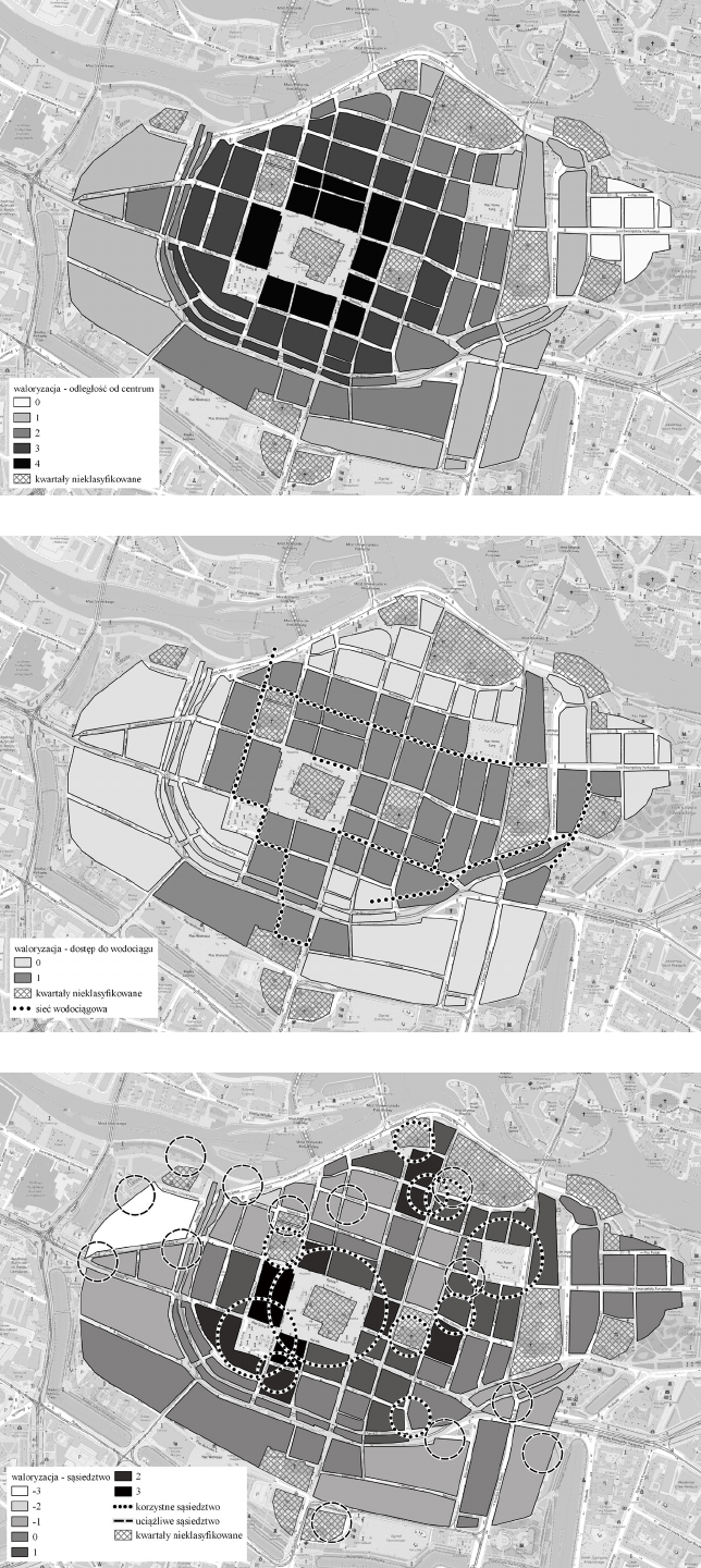
Fig. 1. Wrocław around 1550. Distance of
individual quarters from the centre, scale
divided into five categories (elaborated by
M. Legut-Pintal, M. Grosel)
Il. 1. Wrocław około 1550 roku.
Odległość poszczególnych kwartałów
od centrum, skala według podziału na
pięć kategorii (oprac. M. Legut-Pintal,
M. Grosel)
Fig. 2. Wrocław around 1550. Quarters
with access to municipal waterworks
(elaborated by M. Legut-Pintal,
M. Grosel)
Il. 2. Wrocław około 1550 roku. Kwartały
z dostępem do wodociągów miejskich
(oprac. M. Legut-Pintal, M. Grosel)
Fig. 3. Wrocław around 1550. Map of
good and bad neighbourhoods - colour
intensity corresponds to a point scale
(elaborated by M. Legut-Pintal,
M. Grosel)
Il. 3. Wrocław około 1550 roku. Mapa
korzystnego i uciążliwego sąsiedztwa –
intensywność koloru odpowiada skali
punktowej (oprac. M. Legut-Pintal,
M. Grosel)
76 Maria Legut-Pintal, Mikołaj Grosel
Wrocław – case study
The spatial structure of left-bank Wrocław was a re-
sult of a multi-stage process [21]. The central part of the
urban layout consisted of a rectangular square around
which a grid of approximately perpendicular streets was
delineated. The densely built-up area was surrounded
by a defensive wall and a moat. By a deed of 1261, the
area outside the walls was incorporated into the town. In
1263, the New Town was founded. In the years 1299–
1345, the enlarged city was included in a new perimeter
of the city wall. At the end of the Middle Ages, the area
surrounded by the ring of fortications covered nearly
100 ha. The structure of this area survived almost un-
changed until 1807.
In the case of Wrocław, we do not have a source al-
lowing us to determine the variability of real estate
prices in the pre-industrial period. Mateusz Goliński ex-
amined the social topography in detail and showed the
transformations of urban space in the Middle Ages [18].
However, it does not reach deep into the modern period.
Tax registers from the Baroque period are the most in-
formative source about the assets of property owners but
linking them to specic properties is dicult [22].
Historical plans and vedute provide insight into the
architectural and spatial structure of the city. Most of
them represent the city’s residential district only sym-
bolically and cannot be treated as historical sources
[23]. However, there are plans of Wrocław character-
ised by great detail: Weihner’s plan from 1562, known
mainly from a 19
th
-century copy, the Vroom-Gross plan
and the Hayer plan. Among the reliable ones is Wer-
ner’s drawing plan from around 1750. In many plac-
es, however, the plans have been simplied, and resi-
dential buildings, as the least interesting, were treated
schematically by the authors. Complementary data for
the study of urban space are brought by historical-ar-
chitectural research and studies in the history of urban
planning [21], [24]–[26]. Large-scale rescue archaeo-
logical excavations in city centres have often allowed
the recognition of structure and development dynamics
of entire building blocks [27], [28]. The results of the
architectural and archaeological investigations allowed
for in-depth studies of the quality of material culture on
selected plots.
Elements of urban space have changed over time,
for example due to new developments, degradation of
the urban fabric or disasters. The results of the anal-
ysis will be more accurate the shorter the time slice
for which we acquire a set of data. However, we as-
sume that, apart from certain violent events, such as
war damage, res and the subsequent reconstruction
of the city, the response time to change is relatively
long. Hence, it seems that collecting source material
from a longer period of time, for example, 30–50 years,
of which it is known that there were no violent events
aecting the change in the structure of the city, will not
result in signicant distortions on the scale of the entire
centre. The determination of the time period for which
the data will be comparable should be considered sep-
arately for each surveyed city, as it may depend on the
dynamics and specics of its transformation. In order to
carry out the analysis on the example of Wrocław, two
moments were selected: around 1550 and around 1750.
The rst was documented on a 1562 Weihner view plan
and represents a city at the end of the Middle Ages,
still having some unbuilding reserves for further devel-
opment. The second representation of the city around
1750 is in Friedrich Bernhard Werner’s panorama. It
shows Wrocław at a time when building reserves were
exhausted and it was necessary to increase the height
of buildings .
Residential blocks were assessed in all identied cat-
egories, creating tables of attributes. The source of input
data included the mentioned iconographic documents,
historical socio-topographic analyses [18], documenta-
tion from archaeological and architectural studies, and
their compilations [24], [26]. Due to the presence of dif-
ferent types of variables, the point range was determined
for each variable separately (see below). Analyses and
cartographic materials were developed in a GIS envi-
ronment. The overall assessment consisted of the sum of
partial ratings. Blocks that received the highest cumula-
tive ratings were considered the most attractive for hab-
itation, while those with the lowest ratings were deemed
the least attractive.
Analysis results – Wroclaw around 1550
1. Distance from the city centre
This distance for Wrocław was dened as the distance
of the centroid of the building block from the central point
of the main market square. In order to assess a ve-point
scale was applied using Jenks natural breaks classica-
tion method. The highest score was given to areas near
the market, the lowest to those furthest from the centre
(Fig. 1). The most peripheral zone was located in the
New Town. Signicant distances from the market were
also characteristic of sectors located in the outer city, in
the vicinity of the outer gate of Mikołajska Street and the
gates of Świdnicka, Sakwowa and Oławska. The building
blocks located in the northern part of the Old Town, with-
in the inner perimeter of the walls, near the castle and near
the Piaskowa Gate, were also characterised by a relatively
large distance from the centre.
2. Access to clean water
The course of the city’s water supply system in the 16
th
century was mapped based on historical and archaeolog-
ical sources. At this time investments were made to bring
clean water to the plots. A system of water pumps (Was-
serkunst) was modernised, pumping water from the Oder
and Oława rivers into ceramic waterworks. In the mediae-
val period, clean water could be drawn directly from the
canal of the Oława, the former city moat. However, in the
16
th
century, its cleanliness deteriorated, and the proxim-
ity to the river ceased to be an advantage. The plots adja-
cent to the water supply were considered to have access to
water and were given a score of 1, the others were given
a score of 0 (Fig. 2).
Assessment of the residential space of a pre-industrial city 77
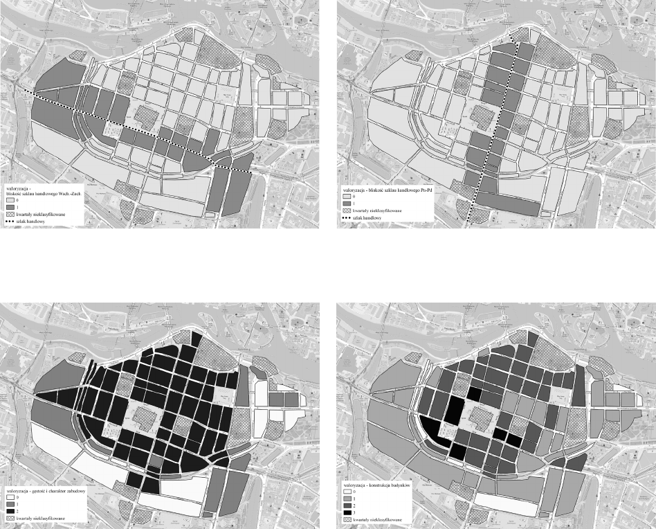
Fig. 4. Wrocław around 1550. Proximity of the trade route: A – east-west route, B – north–south route (elaborated by M. Legut-Pintal, M. Grosel)
Il. 4. Wrocław około 1550 roku. Sąsiedztwo szlaku handlowego: A – szlak wschód–zachód, B – szlak północ–południe (oprac. M. Legut-Pintal, M. Grosel)
A B
Fig. 5. Wrocław around 1550. Density and character of development -
dark quarters mean compact development, light ones indicate
a significant share of green areas
(elaborated by M. Legut-Pintal, M. Grosel)
Il. 5. Wrocław około 1550 roku. Gęstość i charakter zabudowy
– ciemne kwartały oznaczają zwartą zabudowę, jasne wskazują
na znaczny udział terenów zielonych
(oprac. M. Legut-Pintal, M. Grosel)
Fig. 6. Wrocław around 1550. Quality of residential buildings
– the intensity of colour means an increase in the quality of buildings,
from wooden to multi-story brick buildings
(elaborated by M. Legut-Pintal, M. Grosel)
Il. 6. Wrocław około 1550 roku. Jakość zabudowy mieszkalnej
– intensywność koloru oznacza wzrost jakości zabudowy
od drewnianej po wielokondygnacyjne budynki murowane
(oprac. M. Legut-Pintal, M. Grosel)
3. Good and bad neighbourhoods
Based on historical sources, a catalogue of elements
inuencing the perception of neighbourhoods was iden-
tied. A favourable neighbourhood was associated with
the proximity of one of the market squares. The inuence
of the market extends to all blocks near the market. The
prestige of the neighbourhood was also enhanced by the
seats of the authorities and the residences of the elite. In
the middle of the 16th century, Wrocław there were a few
ducal houses of the Dukes of Brzeg, Oleśnica and Opole,
as well as spectacular residences of the bourgeois elite.
The facilities generating impacts that diminished the
value of space included: hospitals, shelters and prisons
were excluded, sick and poor people gathered. Large pro-
duction plants such as municipal slaughterhouses, found-
ries or tannery clusters generated burdensome impacts,
including noise, smell, re hazard.
The map shows points that may have both a positive
and negative impact on the value of neighbouring build-
ings. Favourable inuences increased the score by 1, and
unfavourable inuences decreased it by 1. In the case of
an apartment block that has several factors at play, the
points add up (Fig. 3).
4. Proximity to the trade route
Wrocław was intersected by two main trade routes: the
east-west route known as Via Regia, connecting Kiev to
Western Europe, and the north–south route leading from
the Bochemia to Greater Poland and Pomerania. The ar-
rangement of these routes inside the city walls underwent
changes. During the period of interest, the main course
of the east-west route connected the Oławska Gate and
Mikołajska Gate. The north–south route connected the
Świdnicka Gate and the New Oder Gate, near the impe-
78 Maria Legut-Pintal, Mikołaj Grosel
rial castle. These routes intersected in the southeastern
part of the market square. A parallel thread of the route
running from south to north through the Sakwowa Gate
and Piaskowa Gate was removed with the elimination of
the Sakwowa Gate. The proximity of the trade route was
suitable for commercial premises and for people engaged
in merchant trac, including inns and beer brewing. Hav-
ing property near it should be considered positive from
the point of view of income opportunities. The building
blocks adjacent to the trail received 1 point, the others
0 points (Fig. 4).
5. Density and character of plot development
Dense development occurred within the boundaries of
the inner town, within the rst city walls and along the
main roads leading out of it. Homestead development
characteristic of the suburbs was found in the New Town
and in the southern part of the outer city, along the outer
city walls. On the basis of the degree of development of
the plot and the proportion and nature of green space with-
in the plot, the following categories corresponding to the
scores were determined (Fig. 5):
0 – undeveloped area constitutes more than half of the
building block’s area (vegetable gardens, orchands,
farm character), suburban type of development,
1 – continuous development, developed area consti-
tutes 25–50%, there is free space for development
(building reserve),
2 – continuous development – indicating that the
buildings on the street frontage are connected in all
four sides within the building block; undeveloped area
constitutes less than 25% of the sector, no building re-
serve, there may be greenery with features of a deco-
rative garden, courtyards surrounded with buildings.
6. Building construction
Due to the parameters of building construction that
can be determined from the sources, four categories were
distinguished for the assessment of individual building
blocks (Fig. 6):
0 – predominantly low-rise buildings (one or two sto-
reys), numerous timber-framed buildings (main and
outbuildings), numerous shingle roofs;
1 – brick buildings (two or more storeys), single out-
buildings and half-timbered buildings, also occasion-
ally with shingle roofs;
2 – all brick buildings, two or three storeys, tile roofs;
3 – all brick buildings, three, four storeys or more,
tile roofs, there are buildings with prominent prestige
features (for example, with attics, decorative gables,
arcaded courtyards).
The Weihner plan clearly dierentiated the construc-
tion of buildings, including roof coverings. Zones of in-
ferior wooden buildings, potentially vulnerable to re,
were not only found in the peripheral area furthest from
the centre by the walls. Buildings of imsy materials oc-
curred in large numbers along the inner moat, in the area
formerly occupied by the fortications, which was par-
celled out in the mid-14
th
century. Some of these, on the
west and east sides of the town, were occupied by small
plots of land without facilities inhabited by poorer crafts-
men. In the south-central part, wooden buildings formed
the hinterland of the richer patrician plots. Only in a few
sectors within the inner city were there isolated outbuild-
ings covered with shingles. The most prestigious build-
ings, characterised by architectural ornamentation: attics,
bay windows, rich gables, portal and façade decoration.
They were located, with few exceptions, around the Mar-
ket Square and Solny Square.
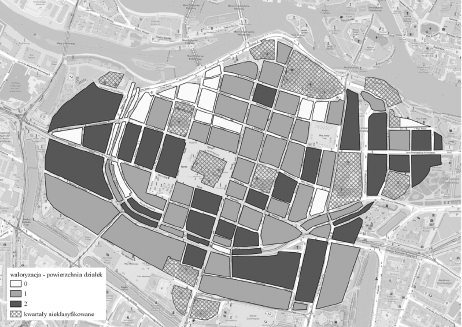
7. Average plot area
The average plot area in a building block was calcu-
lated by dividing the area by the number of plots or front
buildings. In Wrocław, no linear relationship was found
between the average plot size in a building block and its
development. It seems that both very small plot size and
very large plot size were not desirable. Plots that were too
small indicate a small house area and lack of facilities,
while plots that ware too large most often indicate empty
space – a building reserve or homestead character of the
development. Plots of average and slightly above average
size were considered optimal. Plots were divided into ve
categories using the Jenks natural breaks method and then
assigned a point scale (Fig. 7):
–1 point – very small plots,
0 points – small plots,
1 point – medium plots,
1 point – large plots,
0 points – very large plots.
Overall assessment
A synthetic picture of the attractiveness of residential
space was created by summing up the scores for individu-
al building blocks. It was noted that the concentric model
is dominant in the distribution of space quality in the city,
with distance from the centre being crucial to the prestige
Fig. 7. Wrocław around 1550. Assessment of the average plot area
– a low rating was marked in white (it was obtained by plots with too
small and too large an area) (elaborated by M. Legut-Pintal, M. Grosel)
Il. 7. Wrocław około 1550 roku. Ocena średniej powierzchni działki
– niską ocenę oznaczono białym kolorem (uzyskały ją działki o zbyt
małej oraz zbyt dużej powierzchni) (oprac. M. Legut-Pintal, M. Grosel)
Assessment of the residential space of a pre-industrial city 79
of the location. It was also possible to note sectors that
break out of this model, indicating the importance of other
factors such as plot size, quality of development, neigh-
bourhood and proximity to commercial routes.
Analysis results – Wrocław ca. 1750
In order to determine the usefulness of the indicated
method in the study of the dynamics of change within the
city, an analogous procedure was carried out for data from
Wrocław circa 1750. Due to the need to adapt the model to
changing cultural norms, as well as the availability of other
sources, it was necessary to adjust some parameters. Some
of the factors examined remained unchanged, for example
distance from the centre, the course of trade routes. Some
factors lost their importance, like access to the water, which
became common during this period. Location of new de-
velopments, such as the forced labour house and military
casemates associated with the construction of the fortress,
and the elimination of others: the relocation of hospitals,
the transfer of the imperial castle to the Jesuits, the loss of
the status of princely residences, aected their neighbour-
hoods. These factors, together with the emergence of new
trends and the availability of plots of land, have also result-
ed in a change of preference in the location of the palaces of
the elite. The evaluation of the criteria of building density
and construction was veried, observing an overall increase
in the density and quality of buildings across the centre.
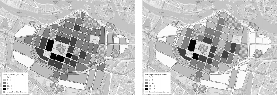
Results of the comparative analysis
Although there were no dramatic changes within the city
walls of Wrocław during the period under study, the synthetic
assessment of Wrocław from around 1750 diers in several
aspects from the one two centuries earlier (Fig. 8). The over-
all score of individual blocks increased, especially in terms of
the density and quality of housing, which corresponds to the
increase in population. The zone of higher ratings has also
moved further outwards from the centre, covering even the
areas directly bordering the fortications, which is related,
among other things, to the inclusion of large plots of land in
the outer city in residential developments. The decline in the
assessment of residential space in some sectors can be linked
to the negative eects of new developments, including those
associated with the construction of the Prussian fortress.
Verification of the method
The state of preservation and compilation of historical
sources for Wrocław makes it impossible to create a map
of property values around 1550 and around 1750 based on
transaction price data. However, the preserved tax records
allow the property tax value to be assigned to property
owners on individual streets [22]. Unfortunately, accord-
ing to the source it is not possible to assign them to indi-
vidual properties. The analysis of this material does, how-
ever, make it possible to approximate the zones with the
highest and lowest tax-paying owners. The juxtaposition
of the picture obtained by the scoring method with the tax
sources from 1564 and1726, conrms the observations re-
garding the economic zoning of the town.
However, slight dierences indicate the existence of
factors that have not been identied and taken into account
in the model, e.g., location of places with a bad reputa-
tion, destruction of real estate. The observed dierences
may result from both model imperfections and a dierent
tax calculation methodology, which included all property
owned by the owner, not just a selected property.
Discussion
The factors used in the above model and their evalu-
ation can be discussed. We assume that the catalogue of
attributes may vary depending on the specic characteris-
tics of an area. The assessment of the attributes and their
weights should also be carried out with adaptation to the
spatial, economic, social and cultural conditions of the
city in question. Where access to water has been wide-
spread, it will not aect property values; where it has been
rationed, it will be a signicant factor.
Fig. 8. The synthetic assessment of residential space for Wrocław in 1550, and in 1750 (elaborated by M. Legut-Pintal, M. Grosel)
Il. 8. Zestawienie syntetycznej oceny przestrzeni mieszkalnej dla Wrocławia w 1550 i 1750 roku (oprac. M. Legut-Pintal, M. Grosel)
80 Maria Legut-Pintal, Mikołaj Grosel
The extent and intensity of the impact of factors is di-
cult to estimate, for example the spread of adverse odours in
a town, the extent of the impact of a market square or a trade
route. For some attributes, their inuence on the assessment
depends very much on the adopted valorisation objective.
The same neighbourhood, from the point of view of residen-
tial comfort, may be perceived as favourable or oppressive.
From the point of view of the value of the property, which can
provide an additional source of income, for example from
renting the premises, the impact of such a neighbourhood
is positive. If we take into account, for example, the noise
generated by trac and tavern-goers, then from the point
of view of the quality of habitation such a neighbourhood
would be negative. Hence, patrician families preferred streets
away from the main thoroughfares for their residences.
Other factors that inuenced the use value of individual
properties were impossible to determine on the scale of
the entire centre. In the case of Wrocław, we have no way
of determining the residential area of the buildings, which
appears to be a fundamental component of valuation for
real estate. However, it can be considered that this charac-
teristic is correlated with values such as location, building
density and building construction – primarily the number
of storeys. It can be assumed that in this case the multi-
dimensional nature of the analysis compensates to some
extent for the lack of this information.
The choice of a basic unit in the form of a building block
may have an impact on the overall model. This choice is
dictated by practical considerations and facilitates analy-
sis, there is no need to exclude streets, squares and public
buildings from the area of the unit. However, the problem of
dierent sizes of units arises. In the case of Wrocław, there
is a clear dierence between the regular building blocks of
the inner city and the large blocks of the outer city. In other
centres, these dierences may be even greater. With large
sectors, we may have to deal with signicant inequalities
within a building block, which will be averaged out and not
visible in the aggregate model. Written sources show that
the tax assessment value for plots located on two streets in
the same block may have diered signicantly. A solution to
this problem could be to divide quarters into smaller units
or to take articial subdivision units, for example, a grid of
squares or hexagons, but this may lead to a reduction in the
clarity of the results.
Conclusions
The simplied space assessment method used in the
above example provides a way to visualise processes that
have so far been presented descriptively and intuitively. It
can also complement historical studies based only on tax
sources. The method will nd application both in stud-
ies of the dynamics of transformation and in comparative
analysis between cities. In the comparative analysis of
pre-industrial cities, it is necessary to take into account the
diverse source base for research and the possibilities of its
elaboration. For many cities, especially those in Central
Europe, archive documentation is often preserved frag-
mentarily, having been destroyed during wars and res.
In the case of large European centres, the data are often so
numerous that their compilation exceeds the capabilities
of research teams. The possibility of a wider application
of the model to other cultural conditions requires adjust-
ing the set of attributes or expanding the number of cate-
gories. Dierent elements may be relevant depending on
climate, environmental conditions, and cultural context.
In the course of further research, we plan to develop and
rene the methodology for comparative studies of cities.
The advantages of the model include conducting dynamic
analyses, the possibility of modifying the model in the
event of acquiring new data, as well as using it to create
visualisations. We believe that the proposed approach can
also be adapted and applied to the evaluation of contemporary
cities in terms of their historical value. It is worth emphasising
the potential of using geographic information system tools
to analyse the structure of a historical city, rather than just
illustrating historical data [29].
The undertaken problem of assessing the residential
space of a pre-industrial city does not exhaust the problem
of wealth inequality within the city. This is because both
the lowest strata of society, who did not own property –
the poor, renters, and the richest strata, who owned several
properties in the city, properties outside the cities or in
several cities, escape from the analysis. The picture could
be complicated even within a single property, owners,
servants and tenants of varying wealth status resided. Many
elements of property status are elusive in spatial analysis
and require in-depth sociological and historical studies.
Acknowledgement
The research was conducted as part of projects funded
by the National Science Centre, grant numbers UMO-
2019/35/B/HS3/00088 and UMO-2020/39/D/HS3/01549.
Assessment of the residential space of a pre-industrial city 81
[1] Bailey G., Time perspectives, palimpsests and the archaeology of
time, “Journal of Anthropological Archaeology” 2007, 26, 198–
223, https://doi.org/10.1016/j.jaa.2006.08.002.
[2] Ortman S.G., Lobo J., Smith M. E., Cities: Complexity, theory
and history, “PLoS ONE” 2020, 15/12, e0243621, https://doi.
org/10.1371/journal.pone.0243621.
[3] Kohler T.A., Smith M.E. (eds.), Ten Thousand Years of Inequali-
ty: The Archaeology of Wealth Dierences, University of Arizona
Press, Tucson 2018.
[4] Smith N., The New Urban Frontier. Gentrication and the Revan-
chist City, Routledge, London–New York 1996.
[5] Thomasson J., A Feudal Way to Gentrify? The Modern Concept of
Gentrication Versus Changes in the Social Topography of a Me-
dieval and Early Modern Town, “Current Swedish Archaeology”
2004, 12/ 1, 187–210.
[6] Hammel-Kiesow R., Hereditas, area und domus: Bodenrecht,
Grundstücksgefüge und Sozialstruktur in Lübeck vom 12. bis zum
16. Jahrhundert, “Jahrbuch für Hausforschung” 1984/1986, 35,
175–177.
[7] Korduba P., Patrycjuszowski dom gdański w czasach nowożytnych,
Neriton, Warszawa 2005.
[8] Chorowska M., Konczewski P., Lasota C., Piekalski J., Parcela
Rynek 6 – ul. Kiełbaśnicza 5 we Wrocławiu. Rozwój zabudowy
i infrastruktury elitarnej działki mieszczańskiej w XIII–IV wiek,
“Śląskie Sprawozdania Archeologiczne” 2012, 54, 49–77.
[9] Kwaśniewski A., Prächtiges haus – festes haus: Notes on the
“urban” and “country“ architectural modus of the house of Wro-
cław patricians in the Early Modern Period, “Architectus” 2022,
1(69),15–26, https://doi.org/10.37190/arc220102.
[10] Buśko C., Stan badań archeologiczno-architektonicznych nad śre-
dniowieczną kamienicą mieszczańską w Polsce, “Archaeologia
Historica Polona” 2000, 10, 83–110.
[11] Piekalski J., Wczesne domy mieszczan w Europie Środkowej. Gene-
za – funkcja – forma. Wydawnictwo Uniwersytetu Wrocławskie-
go, Wrocław 2004.
[12] Mruczek R., Średniowieczne miasto lokacyjne na Śląsku. Kamieni-
ce, wieże mieszkalne i konstrukcje ulic, [in:] E. Łużyniecka (ed.),
Dziedzictwo architektoniczne. W kręgu świata przyrodniczego
i budowli miejskich, Ocyna Wydawnicza Politechniki Wrocław-
skiej, Wrocław 2019.
[13] Piekalski J., Prague, Wroclaw and Krakow: Public and Private
Space at the Time of the Medieval Transition, “Wratislavia An-
tiqua” 2014, 19.
[14] Cieślak I. (ed.), Współczesna waloryzacja przestrzeni zurbani-
zowanej, Wydawnictwo Uniwersytetu Warmińsko-Mazurskiego
w Olsztynie, Olsztyn 2012.
[15] Galiński M., Siwek G., Szuwarski J., Metoda bonitacji punktowej
jako narzędzie waloryzacji zjawisk przestrzennych, “Geomatyka
i Inżynieria” 2013, 2, 5–20.
[16] Chau K.W., Chin T. LA Critical Review of Literature on the Hedo-
nic Price Model, “International Journal for Housing Science and
Its Applications” 2003, 27/2, 145–165.
[17] Robertson H. M., Taylor W. L., Adam Smith’s Approach to the The-
ory of Value, “The Economic Journal” 1957, 67(266), 181–198,
https://doi.org/10.2307/2227781.
[18] Goliński M., Socjotopograa późnośredniowiecznego Wrocławia
(przestrzeń – podatnicy – rzemiosło), Wydawnictwo Uniwersytetu
Wrocławskiego, Wrocław 1997.
[19] Dolynska M., Some principles of interdisciplinary investigation
for recreating the historical topography of urban spaces, “Stu-
dia Geohistorica” 2018, 6, 169–184, https://doi.org/10.12775/
SG.2018.12.
[20] Smith M. E., The archaeological study of neighborhoods and
districts in ancient cities, “Journal of Anthropological Archaeolo-
gy” 2010, 29, 137–154, https://doi.org/10.1016/j.jaa.2010.01.001.
[21] Atlas Wrocławia. Atlas Historyczny Miast Polskich, t. 4: Śląsk,
nr 1, M. Młynarska-Kaletynowa, R. Eysymontt (eds.), Instytut Ar-
cheologii i Etnologii PAN, Wrocław 2017.
[22] Orzechowski K., Właściciele budynków we Wrocławiu w latach 1671
i 1726. Rejestry indykcji podatku szacunkowego we Wrocławiu z lat
1628–1671–1726, Uniwersytet Wrocławski, Wrocław 1993.
[23] Eysymontt R., The Representation of Selected Silesian Cities in
the 15
th
–17
th
Centuries, “Zapiski Historyczne” 2018, 4, 49–75,
http://dx.doi.org/10.15762/ZH.2018.54.
[24] Stein R., Das Breslauer Bürgerhaus, Breslau 1931.
[25] Kwaśniewski A., Dom mieszczański we Wrocławiu w okresie rene-
sansu, [in:] Architektura Wrocławia, Vol. 1: Dom, Instytut Historii
Architektury, Sztuki i Techniki Politechniki Wrocławskiej, Werk,
Wrocław 1995, 105–137.
[26] Brzezowski W., Dom mieszkalny we Wrocławiu w okresie baroku,
Ocyna Wydawnicza Politechniki Wrocławskiej, Wrocław 2005.
[27] Konczewski P., Działki mieszczańskie w południowo-wschod-
niej części średniowiecznego i wczesnonowożytnego Wrocławia,
“Wratislavia Antiqua” 2007, Vol. 9.
[28] Krzywka M., Parcelacja i zagospodarowanie bloku zabudowy
pomiędzy ulicami Kiełbaśniczą, Ruską, Rzeźniczą i św. Mikołaja
a zagadnienie I lokacji Wrocławia. Działka, zabudowa, mieszkań-
cy. Phd thesis, Politechnika Wrocławska, Wrocław 2012.
[29] Hillier A., Invitation to Mapping: How GIS Can Facilita-
te New Discoveries in Urban and Planning History, “Jo-
urnal of Planning History” 2010, 9.2, 122–134, https://doi.
org/10.1177/1538513210366964.
Streszczenie
Ocena przestrzeni mieszkalnej miasta przedindustrialnego. Przykład Wrocławia w XVI i XVIII wieku
Nierówności społeczne w miastach miały swój przestrzenny wymiar już w czasach przedindustrialnych. Na jakość przestrzeni mieszkalnej
w mieście historycznym wpływały różne czynniki, takie jak odległość od centrum miasta, bliskość infrastruktury, dostęp do wody, szlaków
handlowych, targowisk, a także niekorzystne lub uciążliwe sąsiedztwo. Wartość nieruchomości zależała od ich funkcji, stanu konstrukcyjnego
budynków, wielkości budowli i działek. W artykule zaproponowaliśmy metodę oceny i waloryzacji przestrzeni mieszkalnej miasta przedindustrialnego
opartą na ocenie jej wartości użytkowej. Przeprowadziliśmy analizę na przykładzie Wrocławia, średniej wielkości miasta w Europie Środkowej.
Wykorzystaliśmy dane historyczne, archeologiczne, ikonograficzne i analizy geoprzestrzenne opracowane w środowisku systemu informacji
geograficznej. Ocenę w ramach poszczególnych czynników przeprowadziliśmy dla podziału na kwartały dla dwóch okresów – około 1550 roku
i około 1750 roku. Porównując wyniki dla tych dwóch okresów, podjęliśmy próbę prześledzenia zmian, jakie zaszły w wyniku rozwoju miasta
i wydarzeń historycznych. Ogólny obraz pozwolił nam stworzyć charakterystykę przestrzeni mieszkalnej w całym mieście. Metodę zweryfikowaliśmy,
porównując otrzymane wyniki z danymi z ewidencji podatkowych. Uzyskany wynik jest zgodny z wiedzą dotyczącą przestrzennego rozkładu
bogactwa w mieście, co wskazuje, że model może być zastosowany do analizy innych miast, w których nie zachowała się dokumentacja podatkowa.
Słowa kluczowe: metoda bonitacji punktowej, historyczny system informacji geograficznej, przestrzeń mieszkalna
References