2020
2(62)
DOI: 10.37190/arc200213
Introduction
The geographic information system (GIS) is an im-
portant utility that can be considered as a perfect tool to
combine the study of the spatial dimension with the study
of human activities. In archaeology, GIS platforms have
been used since the early nineties of the last century [1].
The GIS environment allows large volumes of data to be
processed, spatial queries to be made, and dierent types
of datasets to be analysed, so it is a cost eective, fast
tool. It helps to organise documentation and is ecient
and precise in aggregating spatial data, especially in archi-
tectural and archaeological conservation [2]. This helps to
provide more information on the formation of a site and
its changes in time, which allows complex spatial analysis
to be conducted.
GIS environments are able to store, manipulate, and
combine multiple types of data sets, for example, satel-
lite images, LiDAR point clouds, TLS point clouds, CAD
les, photo images, GPS coordinates, multiple types of
Izabela Wilczyńska*, Paweł Bronisław Dąbek**,
Bartłomiej Ćmielewski***, Jacek Kościuk****
Integration of project results on a GIS platform
and its impact on conservation strategies
Integracja wyników projektu na platformie GIS
i jej wpływ na strategię konserwatorską
databases (SQL, Access, Oracle), raster images, DTMs,
DSMs, and 3D models. This diversity of data allows com-
plex analyses to be conducted and dierent possible scien-
tic hypothesis to be made. There are many publications
in the form of manuals for GIS technologies [1], [3], [4].
This paper presents the development of a complex 2.5D
GIS database, which was built for the project “Archi-
tectural examination and complex documentation of Sa-
maipata (El Fuerte de Samaipata/Bolivia) site from the
World Heritage List” funded by the Polish National Sci-
ence Centre. The current condition of Samaipata rock and
its progressing erosion
1
is caused by several factors. One
of these is precipitation and the impact of rainwater ow-
ing down the slopes of the rock or accumulating locally.
This problem has already been addressed by earlier stud-
ies [5]–[7], but a more general approach that also encom-
passes the detailed topography of Samaipata rock seems to
be necessary. The main features of the rock surface need
to be considered, especially the areas of local depressions
and natural cracks through which water seeps into the rock.
Methods
The main objective of this research was to combine
spatial data acquisition technologies and a GIS in order to
create multidisciplinary documentation and make a quan-
1
Cf. W. Bartz, J. Kościuk, M. Gąsior, T. Dziedzic, Petrographic,
mineralogical, and climatic analyses, and risk maps for conservation
strategies, in the same issue of “Architectus”.
* ORCID: 0000-0002-1397-8118. Institute of Geodesy and
Geoinformatics, Wroclaw University of Environmental and Life Sciences,
e-mail: izabela.wilczynska@upwr.edu.pl
** ORCID: 0000-0003-0203-3116. Institute of Environmental
Protection and Development, Wroclaw University of Environmental and
Life Sciences.
*** ORCID: 0000-0002-1035-3905. Faculty of Architecture,
Wro cław University of Science and Technology.
**** ORCID: 0000-0003-0623-8071. Faculty of Architecture,
Wrocław University of Science and Technology.
152 Izabela Wilczyńska, Paweł Bronisław Dąbek, Bartłomiej Ćmielewski, Jacek Kościuk
titative assessment of the damage to an archaeological site
caused by nature or human activity. The study followed
the typical process of information transmission, starting
with a topographic survey and nishing with analysis from
non-specialists. These typical steps are described below.
1. Survey and documentation.
There are several techniques for documenting archae-
ological sites. The most eective method for acquiring
spatial data is remote sensing technology [8], [9]. Over
the last twenty years, the development of ground, aerial,
and space equipment and technologies have proven the
eciency of remote sensing technology for documenting
archaeological sites and heritage monuments [10]–[12].
In particular, the fast and huge progress of space technolo-
gy, including a higher spatial resolution and hyperspectral
data, has created new opportunities for better and accurate
analysis, often resulting in many unexpected discoveries
[13]–[15].
2. Specialist interpretation.
The GIS environment can be treated as the best visual-
isation platform for combining dierent types of datasets
[16], [17]. It has a very big impact on multiple analyses
performed on cultural heritage [1], [3]. In particular, the
use of such platforms as ESRI or QGIS allows complex
models derived from laser scanning [18], [19] or photo-
grammetry [20] to be combined with more traditional da-
tasets. Such data overlays allow the broader context of the
analysed material to be seen.
3. Map development.
After analysis and summarising, the GIS environment
can create thematic maps (both 2D and 3D) of a very high
quality and with high spatial resolution.
4. Community.
The rst three steps require specialist knowledge and
skills; the last step is the work with the developed material
by the community, and the creation of their own analyses
and hypotheses.
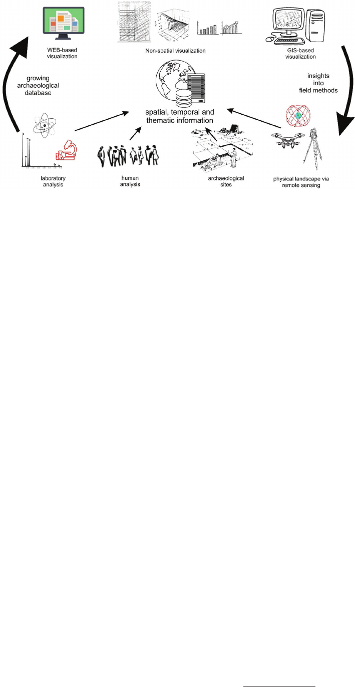
Neha Gupta and Rodolphe Devillers [21] compare GIS
environments to the classic relationship between the col-
lection of data in the archaeological eld, information
integration, and data visualization and interpretation
(Fig. 1). This comparison shows the main advantage of
GIS databases is that they can integrate dierent types of
datasets. Even if we do not have geolocations due to spe-
cic types of data (for example, text descriptions), we can
easily add our data to a larger spatial database regarding
the particular project. Additionally, if in a text description
we can highlight some specic factors, later we can per-
form spatial analysis using them.
For example, hydrological analysis allows potential
surface runo routes made by natural erosion and people
to be identied [22], [23]. The ArcMap application with
the ArcHydro extension [24] was used in the hydrological
analysis of this study. The goal was to identify potential
surface runo routes in the natural terrain and those de-
veloped by people. The basis of the study was a digital
terrain model (DTM) with a 5 cm spatial resolution. Al-
titude data from TLS (point spacing 0.01, ca. 425 million
points
2
, were used to create a spatial spacing 5 cm DTM
in a grid format.
When preparing data for analyses, special attention
was paid to the hydrological correctness of the numeri-
cal terrain model [25], [26]. For this purpose, the function
Fill Sinks in ArcHydro [24] was used. This corresponds
to the Fill function in the Spatial Analyst extension [27].
The purpose of Fill Sinks is to ll in drainage areas, the
occurrence of which, even on a microscale, can limit the
continuity of runo routes. The Fill Sinks function aligns
and lls places with the biggest depressions to the level of
the surrounding area.
The natural step before Fill Sinks is the use of the
DTM Reconditioning function in ArcHydro. Its task is to
stamp the watercourse beds into the DTM to indicate the
main runo routes. However, due to the characteristics of
what was being analysed, this was abandoned in the rst
step and was used only after lling the drainage areas.
Using the DTM Reconditioning function identied nat-
ural cracks, terrain cracks, and intentional human-created
runo routes. It was decided to take this step simultane-
2
Cf. J. Kościuk, B. Ćmielewski, M. Telesińska, A. Kubicka, 3D
terrestrial laser scanning of El Fuerte de Samaipata, in the same issue
of “Architectus”.
Fig. 1. A representation
of the cyclical relationship
between collecting data from
the archaeological field,
information integration, and data
visualization and interpretation
(adopted from [21])

IntegrationofprojectresultsonaGISplatform / IntegracjawynikówprojektunaplatformieGIS 153
ously to take into account runo through natural forms of
the terrain, and to demonstrate the ow of water channels
made by people. Then in ArcHydro, a runo direction
model was developed (Flow Direction [28]) based on the
DTM, and a runo accumulation model (Flow Accumula-
tion [27], [28]), was created to determine the hydrological
conditions of surface runo. By using subsequent mod-
ules in the ArcHydro extension, potential runo routes
were developed. Following this, the Stream Denition
and Stream Segmentation (to develop concentrated run-
o routes) and Catchment Grid Delineation (to determine
areas from which concentrated runo occurs) functions
were used.
The algorithm conditioning the accuracy of the results
obtained was the Stream Denition function, in which the
minimum surface area of the catchment area of a single
water route was taken into account. An even surface was
assumed to be 4000 pixels, which in the case of spatial
resolution in the DTM corresponds to an even surface
of 10 m
2
. Ultimately, potential runo routes were deter-
mined by taking into account natural forms of terrain, in-
cluding cracks formed over the years, and forms created
by people to manage water on the site. As a result, a layer
of microcatchment areas was created.
Results and discussion
GISinfieldwork
During the survey, especially during the photogram-
metric acquisitions of images, the mobile GIS was a very
useful supporting tool. Due to very bad atmospheric con-
ditions, especially extremely strong winds, it was not pos-
sible to y a drone, so we were forced to acquire images
from the ground by placing cameras on long telescopic
sticks ca. 3–4 m above our heads. Even when we created
virtual lines of walking on the rock, sometimes it was not
possible to avoid errors and create gaps or very poor lon-
gitudinal and transverse coverage. Due to this, every day,
we estimated the positions of images in the global coordi-
nate system and checked the coverage. If we found gaps,
we exported the .shp le to a mobile phone application
(Locus Map on Android) and navigated to this area using
mobile phone GPS.
A similar workow was used when we captured the
multispectral images. This workow forced us to create
temporary layers such as:
1.
RGB camera position reconstructed each day (Fig. 2).
2. Temporary orthoimages from each day.
3. Position of multispectral images reconstructed each
day.
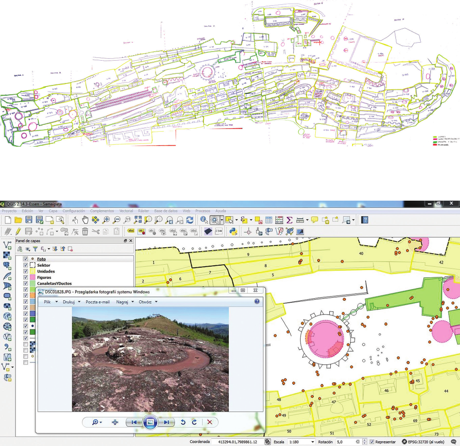
Additionally, during the eld survey and inspection
by Giuseppe Oreci, we created two temporary layers to
organize the data. One was the schematic plan of the site
(Fig. 3) and the second was used to collect data from anal-
ysis of objects found on the rock such as petroglyphs, wa-
ter tanks, seats and terraces, and other important features
(Fig. 4).
Cameralwork
After eldwork seasons were completed, nal docu-
mentation was prepared. Several groups of researchers
contributed to delivering data for particular thematic lay-
ers of the GIS. They all used three basic deliverables that
were prepared in advance: DEM, orthoimages from TLS,
and RGB and multispectral orthoimages from the photo-
grammetric project. The nal product was vector (CAD)
documentation of the site as well as detailed analysis of
more specic features such as unclear (eroded) petro-
glyphs. A description of the nal layers of the whole GIS
is presented in Table 1.
The basic set of data (layers from 1–23) presented above
was further used to produce more advanced analysis that
was also incorporated into the GIS project (layers 24–32).
Some of these analyses are presented below.
Fig. 2. RGB camera position reconstructed each day. Each day is shown with a different colour (elaborated by B. Ćmielewski)
154 Izabela Wilczyńska, Paweł Bronisław Dąbek, Bartłomiej Ćmielewski, Jacek Kościuk
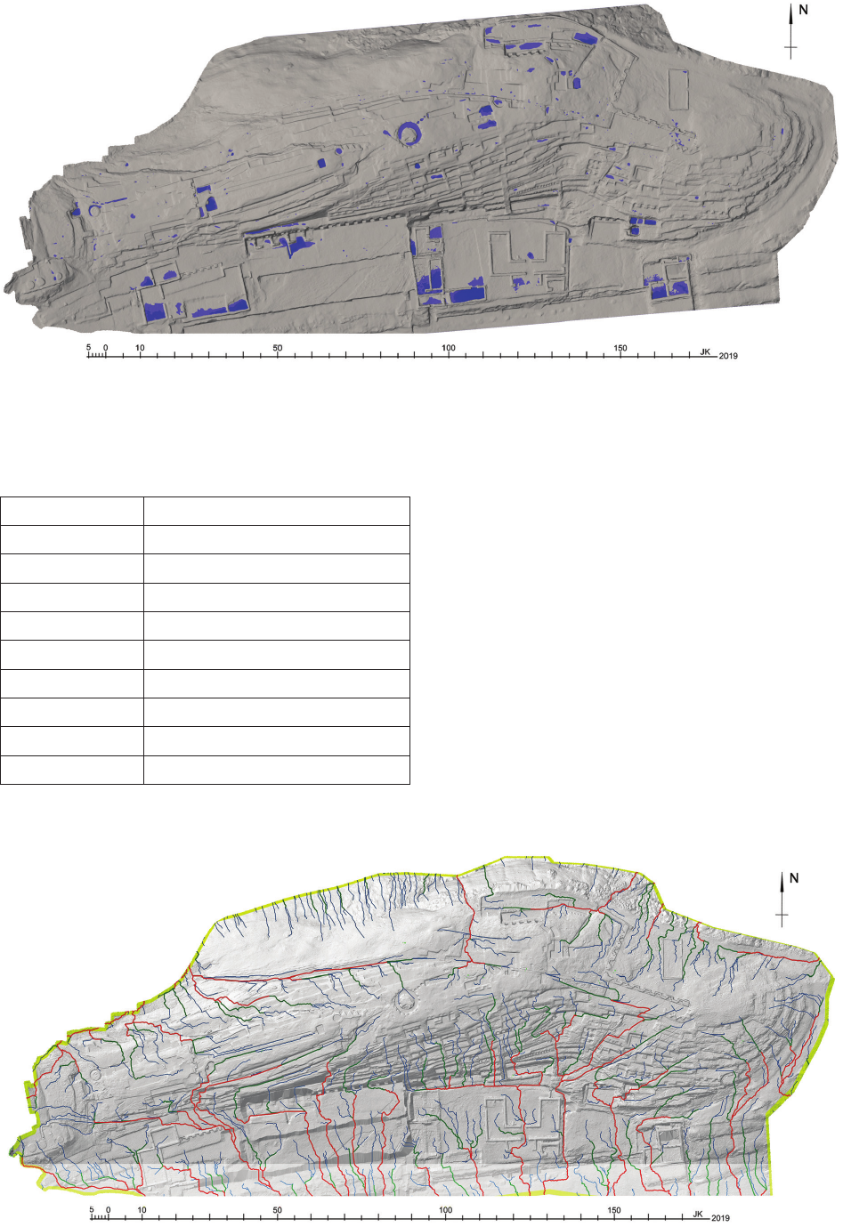
Hydrological analysis
Local depressions were searched for in a Bentley Micro-
Station V8i environment – contour lines were generated
every 10 cm and those that formed enclosed areas were se-
lected. The results were presented in colour scale re ect
ing the maximum depth of accumulated water (Fig. 5).
The ArcMap environment was then used to automat-
ically select depressions without a drain and to smooth
them as required for hydrological analysis, for which the
rst step was the calculation of water catchments. The
biggest ones were of 719.08 m
2
, and the mean area was
164.42 m
2
. The number of catchments calculated for the
whole site of Samaipata rock is presented in Table 2. Most
of the catchment areas were between 0 and 300 m
2
.
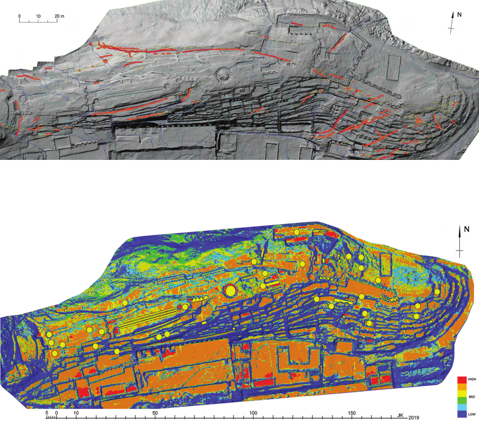
The next step in the hydrological analysis was to deter-
mine the water ow direction. This resulted in the creation
of a drainage line model (Fig. 6) with lines along which
rainwater will most likely ow down.
Spatial analysis
The drainage line model was used to check the inter-
action between rainwater owing down the slope of the
hill and existing natural cracks of the rock. These places
are of particular interest for conservation because of the
negative impact of rainwater inltrating the rock. All the
main cracks were selected as well as the drainage lines,
and a 25 cm buer zone was automatically created around
their intersections, thus pointing to the places with the
highest risk of rainwater inltration (Fig. 7). This anal-
ysis was further used to prepare risk maps for conserva-
tion that could cumulatively calculate degradation factors.
This kind of data is of big importance for any conservation
Fig. 3. Schematic plan of the site during the 2016 survey season
(elaborated by G. Orefici)
Fig. 4. Organisation of iconographic fieldwork data during the 2016 survey season
(elaborated by I. Wilczyńska)

IntegrationofprojectresultsonaGISplatform / IntegracjawynikówprojektunaplatformieGIS 155
Table 1. Final GIS layers developed for the project
(elaborated by I. Wilczyńska)
Numbers Final GIS layers Short description
1 Borders of examination Range of examination area
2 Sectors New borders of sectors were determined during office work
3 Sector name Each sector was given a name
4 RGB orthoimages RGB orthoimages from the photogrammetric project of Samaipata rock
5 Multispectral orthoimages Multispectral orthoimages from the photogrammetric project of Samaipata rock
6 TLS DTM hill-shade A hill-shaded DTM developed from a filtered 3D point cloud created using TLS
7 Niches and terraces Niches and terraces carved on the rock
8 Offering holes Offering pits
9 Water channels Traces of water channels
10 Inca walls Inca architecture built on Samaipata rock
11 Inca tracing lines Lines traced on the rock by Inca builders
12 Quincha walls Walls constructed using the quincha technique
13 Colonial walls Buildings from the colonial period
14 Stairs Stairs carved in the rock
15 Wall negatives Traces of no longer existing walls
16 Post holes Holes in the rock for the construction of quincha walls
17 Contemporary constructions Contemporary platforms for visitors
18 Landscape rock The rock formation
19 Petroglyphs Location of petroglyphs
20 Petroglyph description Text describing a petroglyph based on analysis from the iconographic survey in 2016
21 RAW image of petroglyphs Images taken during the iconographic survey in 2016
22 RTI/PTM models of selected petroglyphs Models from the RTI/PTM of selected petroglyphs
23 Main natural cracks Main lines of natural cracks
24 Hydrology major lines The main watercourses
25 Hydrology minor lines The minor watercourses
26 Depressions without drains Permanent deposits of rainwater
27 Mineralogical samples Places from where the mineralogical samples were collected
28 Risk map – green vegetation The areas of green vegetation
29 Risk map – lichens The areas attacked by lichens, fungi, and algae
30 Risk map – loose lithic material Deposits of loose lithic material
31 Risk map of thermal shock The areas exposed to the risk of thermal shock during daily temperature changes
32 Risk map of wind erosion The areas exposed to abrasive wind
33 Restoration risk zones The areas of particular restoration risks
strategy. For example, juxtaposing the petroglyphs and ar-
eas where many dierent degradation factors accumulate
can show which petroglyphs are most at risk from deg-
radation (Fig. 8). In the future, using our GIS can allow
further analysis of this kind to be developed in line with
any new requirements of site management.
Conclusions
In the last decades, the use of GIS platforms for cul-
tural heritage management has become very important.
These environments make it possible to develop an eec-
tive spatial database for archaeological sites and architec-
156 Izabela Wilczyńska, Paweł Bronisław Dąbek, Bartłomiej Ćmielewski, Jacek Kościuk
Fig. 5. Depressions without drains (elaborated by J. Kościuk)
Fig. 6. Model of drainage lines (where colours of drainage lines mean the size of catchment area: red 100 m
2
, green 40 m
2
, blue 10 m
2
)
(elaborated by P.B. Dąbek)
Table 2. Statistic of catchments on Samaipata rock
(elaborated by P. Dąbek)
Area [m
2
] Number of catchments
0–50 39
51–100 13
101–200 95
201–300 33
301–400 15
401–500 3
501–600 4
601–700 1
701–800 1
tural objects. This creates a powerful toolset of analytical
instruments both for a micro and macro scale. The case of
El Fuerte de Samaipata shows how eective a GIS can be,
both in eldwork during the data collection process and
later in oce analysis.
Using GIS environments allows very quick and precise
spatial analysis to be made, which is especially important
for conservation and site management strategies at all ar-
chaeological sites.
From the point of view of conservation strategy, the
study provided very important results. Risks related
to atmospheric precipitation consist of three dierent
factors:
– Rainwater accumulated on the rock surface for a long
time causes hydrolysis and the subsequent washing-out of
the binder of the sandstone rock;
IntegrationofprojectresultsonaGISplatform / IntegracjawynikówprojektunaplatformieGIS 157
Fig. 7. Map of rainwater infiltration risk. Buffers around intersections between the main cracks (red) in the rock and rainwater runoff lines (blue)
(elaborated by B. Ćmielewski)
Fig. 8. Juxtaposition of petroglyphs (yellow) and zones of cumulative degradation factors (blue – low, green – medium, red – high)
(elaborated by B. Ćmielewski)
– Water leaking into the rock through natural cracks
also washes out the binder, and in addition, its local eu-
sions in the lower parts of the slopes are where rock-de-
stroying lichens, mosses, and algae develop;
– Water freezing in the rock crevices, which causes the
rock to break.
In the light of the described climatic and topographic
factors, as well as the results of petrographic and miner-
alogical studies of local sandstone [13], it is necessary to
consider the problem of water retained in local depres-
sions. The other recommendation to consider is to seal the
most important natural cracks in the rock (Fig. 7).
References /Bibliografia
[1] Geographical Information Systems in Archaeology, J. Conolly,
M. Lake (eds.), Cambridge Manuals in Archaeology, Cambridge
University Press, United Kingdom, 2006.
[2] Marwick B., Hiscock P., Sullivan M., Hughes P., Landform bound-
aryeects onHoloceneforager landscapeuse inarid SouthAus-
tralia, “Journal of Archaeological Science: Reports” 2017, Vol. 19,
864–874, doi: 10.1016/j.jasrep.2017.07.004.
[3] Spatial technology and archaeology: the archaeological applica-
tions of GIS, D. Wheatley, M. Gillings (eds.), Taylor & Francis,
London–New York 2002, doi: 10.4324/9780203302392.
[4] Mehrer M., Wescott K., GIS and archaeological site location mod-
eling, CRC Press, Boca Raton 2006, doi: 10.1201/9780203563359.
[5] Avilés S., Conservazione del tempio della rocca scolpita di Samai-
pata – Santa Cruz, Bolivia (Sudamerica), Tesi di Master: Università
di Bologna – Sede di Ravenna, Facoltà di Conservazione dei Beni
Culturali, Dipartimento di Storie e Metodi per la Conservazione dei
Beni Culturali, 2002, www.stonewatch.de/media/download/sc%20
04.pdf [accessed: 20.05.2019].
[6]
Avilés S., Introduzione alla conservazione della Roccia Scolpita di Sa-
maipata, Bolivia 2011, http://www.rupestreweb.info/samaipata.html
[accessed: 20.05.2019].
158 Izabela Wilczyńska, Paweł Bronisław Dąbek, Bartłomiej Ćmielewski, Jacek Kościuk
[7] Avilés S., LaconservacióndelaRocaSagradadeSamaipata, [in:]
A. Meyers, I. Combès (comp.), El Fuerte de Samaipata. Estu dios ar-
queológicos, Biblioteca del Museo de Historia, Universidad Autó-
noma Gabriel René Moreno, Santa Cruz de la Sierra 2015, 161–170.
[8] Spreaco M.C., Franci F., Bitelli G. et al., Remote sensing tech-
niques in a multidisciplinary approach for the preservation of cul-
tural heritage sites from natural hazard: The case of Valmarecchia
Rock Slabs (RN, Italy), “Engineering Geology for Society and
Territory” 2015, Vol. 8, 317–321, doi: 10.1007/978-3-319-09408-
3_5.
[9] Cigna F., Lasaponara R., Masini N., Milillo P., Tapete D., Persistent
scatterer interferometry processing of COSMO-SkyMed StripMap
HIMAGE time series to depict deformation of the historic centre of
Rome, Italy, “Remote Sensing” 2014, Vol. 6, Iss. 12, 12593–12618,
doi: 10.3390/rs61212593.
[10] Casana J., Kantner J., Wiewel A., Cothren J., Archaeological aerial
thermography: a case study at the Chaco-era Blue J community,
NewMexico, “Journal of Archaeological Science” 2014, Vol. 45,
207–219, doi: 10.1016/j.jas.2014.02.015.
[11] Agapiou A., Alexakis D.D., Sarris A., Hadjimitsis, D.G., Evalu-
ating the potentials of sentinel-2 for archaeological perspective,
“Remote Sensing” 2014, Vol. 6, Iss. 3, 2176–2194, doi: 10.3390/
rs6032176.
[12] Chase F.A., Chase Z.D., Weishampel F.J. et al., Airborne LiDAR,
archaeology, and the ancient Maya landscape at Caracol, Belize,
“Journal of Archaeological Science” 2011, Vol. 38, Iss. 2, 387–398,
doi: 10.1016/j.jas.2010.09.018.
[13] Sarris A., Papadopoulos N., Agapiou A. et al., Integration of geo-
physical surveys, ground hyperspectral measurements, aerial and
satellite imagery for archaeological prospection of prehistoric
sites:thecase study of Vésztő-Mágor Tell, Hungary, “Journal of
Archaeological Science” 2013, Vol. 40, Iss. 3, 1454–1470, doi:
10.1016/j.jas.2012.11.001.
[14] Aqdus S.A., Drummond J., Hanson W.S., Discovering archaeo-
logical cropmarks: A hyperspectral approach, “The Internation-
al Archives of the Photogrammetry, Remote Sensing and Spatial
Information Sciences” 2008, Vol. 37, 361–365, https://www.isprs.
org/proceedings/XXXVII/congress/5_pdf/64.pdf.
[15] Cavalli R.M., Colosi F., Palombo A., Pignatti S., Poscolieri M.,
Remote hyperspectral imagery as a support to archaeological
prospection, “Journal of Cultural Heritage” 2007, Vol. 8, Iss. 3,
272–283, doi: 10.1016/j.culher.2007.03.003.
[16] Dell’Unto N., Leander A.M., Dellepiane M. et al., Digital recon-
structionandvisualizationinarchaeology:Case-studydrawnfrom
the work of the Swedish Pompeii Project, “IEEE Xplore” 2013,
621–628, doi: 10.1109/DigitalHeritage.2013.6743804.
[17] De Reu J., Plets G., Verhoeven G. et al., Towardsathree-dimen-
sional cost eective registration of the archaeological heritage,
“Journal of Archaeological Science” 2013, Vol. 40, Iss. 2, 1108–
1121, doi: 10.1016/j.jas.2012.08.040.
[18] Dell’Unto N., Landeschi G., Leander Touati A.M. et al., Experienc-
ingAncient Buildings from a 3DGISPerspective: ACase Drawn
fromtheSwedishPompeiiProject, “Journal of Archaeological Meth-
od and Theory” 2016, 23, 73–94, doi: 10.1007/s10816-014-9226-7.
[19] Landeschi G., Dell’Unto N., Lundqvist K. et al., 3D-GIS as a Plat-
form for Visual Analysis: Investigating a Pompeian House, “Journal
of Archaeological Science” 2016, Vol. 65, 103–113, doi: 10.1016/
j.jas.2015.11.002.
[20] Larsson L., Trinks I., Söderberg B. et al., Interdisciplinary archae-
ologicalprospection,excavationand3Ddocumentationexempli-
edthroughtheinvestigationofaburialattheIronAgesettlement
site of Uppåkra in Sweden, “Archaeological Prospection” 2015,
Vol. 22, Iss. 3, 143–156, doi: 10.1002/arp.1504.
[21] Gupta N., Devillers R., Geographic Visualization in Archaeology,
“Journal of Archaeological Method and Theory” 2017, Vol. 24,
852–885, doi: 10.1007/s10816-016-9298-7.
[22] Woodrow K., Lindsay J.B., Berg A.A., Evaluating DEM condition-
ingtechniques,elevationsourcedataandgridresolutionforeld-
scalehydrologicalparameterextraction, “Journal of Hydrology”
2016, Vol. 540, 1022–1029, doi: 10.1016/j.jhydrol.2016.07.018.
[23] Dąbrowska J., Dąbek P.B., Lejcuś I., A GIS based approach for the
mitigationofsurfacerunotoashallowlowlandreservoir, “Eco-
hydrology and Hydrobiology” 2018, Vol. 18, Iss. 4, 420–430, doi:
10.1016/j.ecohyd.2018.07.002.
[24] Arc Hydro: GIS for Water Resources, D.R. Maidment (eds.), Envi-
ronmental Systems Research Institute, U.S., 2002.
[25] Brubaker K.M., Myers W.L., Drohan P.J., Miller D.A., Boyer E.W.,
The use of LiDAR terrain data in characterizing surface roughness
and microtopography, “Applied and Environmental Soil Science”
2013, 1–13, doi: 10.1155/2013/891534.
[26] Thomas I.A., Jordan P., Mellander P.E. et al., Improving the iden-
ticationofhydrologicallysensitiveareasusingLiDARDEMsfor
the delineation and mitigation of critical source areas of diuse
pollution, “Science of The Total Environment” 2016, Vol. 556,
276–290, doi: 10.1016/j.scitotenv.2016.02.183.
[27] Tarboton D.G., Bras R.L., Rodriguez-Iturbe I., OntheExtractionof
ChannelNetworksfromDigitalElevationData, “Hydrological Pro-
cesses” 1991, Vol. 5, Iss. 1, 81–100, doi: 10.1002/hyp.3360050107.
[28] Jenson S.K., Domingue, J.O., Extracting Topographic Structure
from Digital Elevation Data for Geographic Information System
Analysis, “Photogrammetric Engineering and Remote Sensing”
1988, Vol. 54, No. 11, 1593–1600.
Abstract
The geographic information system (GIS) has become a very popular and useful tool to aggregate and process spatial data. In this paper, the im-
plementation of data obtained during survey seasons at the El Fuerte de Samaipata (Bolivia) archaeological site and results of data analysis on the
GIS platform are presented. In addition to the thematic layers, a description of the sectors and archaeological relics was added to the whole system.
The implemented layers are related to orthoimages created from terrestrial laser scanning (TLS) and from close range photogrammetry (in visual,
spectral, and infrared light), raw photos of petroglyphs, a highly detailed vector plan of the site, conservation risk maps, new spatial divisions, descrip-
tion layers, and a digital terrain model (DTM) based on the results of TLS. Such a system, with an implemented DTM, allows rainwater runo and
its impact on the archaeological site to be analysed. Thus, the paper presents a study on some hydrological conditions of the Samaipata rock. It is part
of the larger research project “Architectural examination and complex documentation of Samaipata (El Fuerte de Samaipata/Bolivia) site from the
World Heritage List”. The results of this study are considered mainly from the point of view of conservation recommendations and strategies. Same
aspects, however, may inuence future studies on the chronology and cultural aliation of the Samaipata rock carvings.
Key words: GIS, spatial analysis, data integration, conservation, hydrology
Acknowledgements /Podziękowania
Thepresentedworkisapartoftheresearchsponsoredbythegrantgiv-
entotheWrocławUniversityofScienceandTechnologybythePolish
National Science Centre (grant No. 2014/15/B/HS2/01108). Additio-
nally,themunicipalityofSamaipata,representedbyMayorFalvioLó-
pes Escalera, contributed to this research by providing the accommo-
dationduringthe eldwork in Juneand July 2016, aswellas in July
2017. The Ministry of Culture and Tourism of Bolivia kindly granted
all necessary permits (UDAM No. 014/2016; UDAM No. 060/2017).
The research was conducted in close cooperation with the Centrefor
Pre-Columbian Studies of the University of Warsaw in Cusco. Spe-
cialists from many other universities and research centres also joined
the project.
IntegrationofprojectresultsonaGISplatform / IntegracjawynikówprojektunaplatformieGIS 159
Streszczenie
System informacji geogracznej (GIS) stał się bardzo popularnym i użytecznym narzędziem do agregowania i przetwarzania danych przestrzennych.
W niniejszym artykule przedstawiono implementację danych uzyskanych podczas sezonów badań na stanowisku archeologicznym El Fuerte de
Samaipata (Boliwia) oraz wyniki analizy danych na platformie GIS. Oprócz warstw tematycznych do całego systemu dodano opis sektorów i za-
bytków archeologicznych. Zaimplementowane warstwy są powiązane z ortoobrazami utworzonymi z naziemnego skanowania laserowego (TLS),
fotogrametrii bliskiego zasięgu (w świetle wizualnym, spektralnym i podczerwonym), surowych zdjęć petroglifów, bardzo szczegółowego planu
wektorowego, map ryzyka, nowego podziału przestrzennego stanowiska, warstw opisowych oraz cyfrowego model terenu (DTM) opartego na wy-
nikach TLS. Taki system przetwarzania danych z wdrożonym DTM pozwala na analizę spływu wody deszczowej i jej oddziaływania na stanowisko
archeologiczne. W związku z tym w artykule przedstawiono badania niektórych warunków hydrologicznych skały Samaipata. Badania są częścią
większego projektu „Badania architektoniczne i kompleksowa dokumentacja stanowiska Samaipata (Fuerte de Samaipata/Boliwia) z Listy Świato-
wego Dziedzictwa”. Wyniki tych prac rozpatrywane są głównie z punktu widzenia zaleceń i strategii ochrony skały. Te same aspekty mogą jednak
wpłynąć na przyszłe badania dotyczące chronologii i przynależności kulturowej rzeźb skalnych Samaipata.
Słowa kluczowe: GIS, analizy przestrzenne, integracja danych, konserwacja zabytków, hydrologia
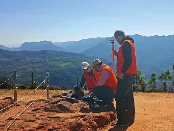
Measuring GPS cooridates
(photo by M. Gąsior)
Pomiar współrzędnych GPS
(fot. M. Gąsior)