2020
2(62)
DOI: 10.37190/arc200209
Introduction – the site and the scope of work
Despite the strong Incan characteristics of Samaipata,
the site served as a sacred place for many pre-Hispanic lo-
cal cultures, and its origins date back to around 300 AD. Its
present form is mainly the result of activities from the time
of Inca dominance over this area, which also coincides with
the last century of the Inca Empire before it collapsed dur-
ing the Spanish conquest in the 2
nd
half of the 16
th
century.
For more than two centuries, the site has attracted
scholarly attention [1]–[4], mainly due to the unique scale
and density of decorations covering the natural rock.
These decorations include not only multiple terraces,
platforms, and water reservoirs, but also many gural and
geometrical petroglyphs, all of them arranged in a very
complicated layout (Fig. 1).
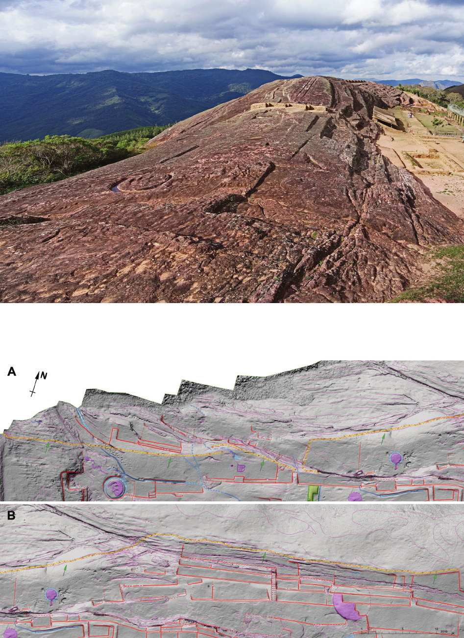
Between those various carvings covering nearly the
whole surface of the rock, several circular openings with
diameters ranging from 8 cm to approximately 60 cm
are extant. Apart from those that are of natural origin or
caused by rock erosion, these openings are usually inter-
preted as oering holes for ceremonial libations. They
typically neighbour gural petroglyphs either as singular
holes or are grouped in irregular patterns. Up until now,
much less attention was placed on another group of open-
ings that are arranged in a long line alongside the northern
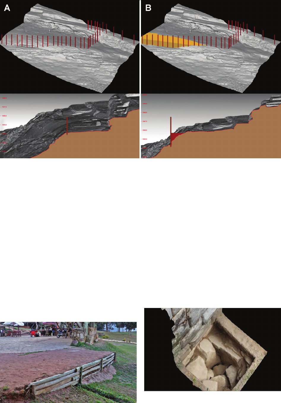
slope of the rock (Fig. 2).
Janusz Kogut*, Jacek Kościuk**, Anna Kubicka***
Interpretation of traces of hypothetical quincha walls in Samaipata
Interpretacja śladów hipotetycznych ścian quincha w Samaipata
Two much shorter lines of such holes (Fig. 3) can also
be found on the southern hillside on the border between
sector W04 and W07, as well as on the border between
sector W11 and S12
1
. During our survey in 2016, we de-
tected yet another group of similar holes in sector S28
– barely visible traces of such holes are arranged there in
a rectangular shape, measuring roughly 2.5 × 4.5 m.
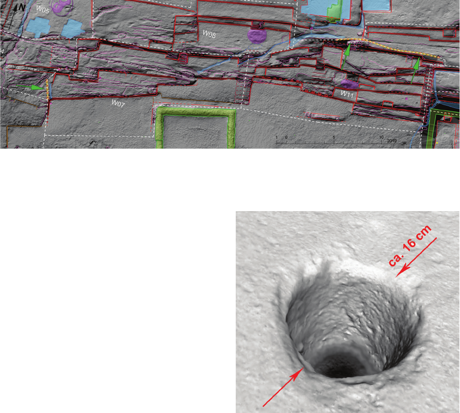
The diameter of all the holes on the northern slope of
the hill ranges from 12 to 20 cm, and they were drilled
more than 20 cm into the surface of the rock (Fig. 4).
There is a consensus among researchers that these holes
were used to x vertical wooden posts. The discussion,
however, concerns the dating and the function that these
posts served.
One local hypothesis assumes that the posts were used
to attach torches that illuminated rituals performed on the
rock. However, the most common interpretation is that
the posts were part of the construction of traditional quin-
cha walls. According to the authors of this article, three
fragments of a quincha wall located on the southern slope
are the relics of buildings that were once there. However,
three separate sections of post-holes located on the north-
ern slope we interpret as free-standing walls, not asso-
ciated with any building.
Two arguments are usually raised against this latter
interpretation. First of all, it is noted that at the base of
a quincha wall, there is usually a shallow ditch. In our
case, there is no such feature. The second argument consid-
ers the local weather conditions, namely the strong winds
1
Cf. J. Kościuk, G. Oreci, M. Ziółkowski, A. Kubicka, R. Muñóz
Ri solazo, Description and analysis of El Fuerte de Samaipata in the
light of new research, and a proposal of the relative chronology of its
main elements, in the same issue of “Architectus”.
* ORCID: 0000-0001-5728-1809. Faculty of Civil Engineering,
Cracow University of Technology, e-mail: jkogut@pk.edu.pl
**
ORCID: 0000-0003-0623-8071. Faculty of Architecture, Wroc -
ław University of Science and Technology.
***
ORCID: 0000-0001-5442-3947. Faculty of Architecture, Wroc -
ław University of Science and Technology.
68 Janusz Kogut, Jacek Kościuk, Anna Kubicka
Fig. 2. The northern slope of Samaipata rock.
The green arrows mark rows of round holes for quincha posts.
The hill-shaded 3D cloud from terrestrial laser scanning (TLS) is used as the background:
A – the western part;
B – the eastern part
(elaborated by J. Kościuk)
Fig. 1. El Fuerte de Samaipata, as seen from the west
(photo by J. Kościuk)
Interpretation of traces of hypothetical quincha walls in Samaipata / Interpretacja śladów hipotetycznych ścian quincha w Samaipata 69
at the top of the rock. Therefore, the main objective of this
study will be to prove that a quincha wall could withstand
the windy conditions of the northern slopes of Samaipata.
Albert Meyers, the director of the German Samaipata Ar-
chaeological Research Project (Proyecto Arqueológico en
Samaipata, PIAS) in the years 1992–1996, drew the authors’
attention to another possible interpretation. The holes drilled
in the rock may theoretically come from the colonial period
and be a part of the Spanish fortications strengthening the
top of the hill as the last defence point. Such dating cannot
be a priori excluded in the absence of any relevant evidence
that could oer absolute dating of the drilled holes.
An exchange of e-mails resulted in the following con-
clusions. The Spaniards who arranged the military post
there would have wanted to protect the margins of their
settlement located south of the rock. Fortifying the top of
the rock from the northern side, where the natural slope is
so steep that one can hardly imagine any attacks from this
side, makes no military sense. Therefore, providing shield-
ing from the wind or undesirable observation remains the
only plausible explanation for the function of the postulat-
ed quincha wall. Were Spaniards interested in this? During
discussions, we did not nd any arguments in favour of
such an interpretation, so in our opinion, the most likely
provenience is from Inca times.
Basic information on pre-colonial quincha walls
and interpretation of the function
of vertical wooden posts
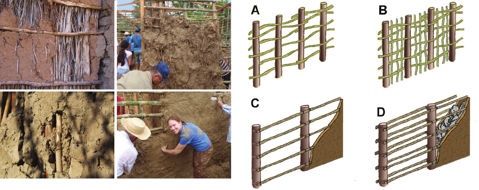
The term quincha is borrowed from the Quechua verb
(Quinchani – cercar de septo) [5] denoting separating
by a septum. Unlike modern constructions also referred
to as quincha, the pre-Hispanic quincha walls were not
timber frame-based. The traditional form of this type of
construction is still popular not only in the Andean region,
but also in the whole of Central America (Fig. 5). Internet
re sources are full of webpages devoted to local initiatives
promoting the use of this simple and economical con-
struction technology [6].
In contrast, post-Hispanic and modern timber frame-
based quincha constructions are of interest to many sci-
entists, mainly due to their tolerance to seismic phenom-
ena [7], [8] and problems related to the maintenance and
conservation of architectural heritage [9]. Simple pre-His-
panic constructions of quincha walls are practically not
analysed in terms of strength, and their models are not
subjected to experimental strength tests. Due to this, it is
dicult to solve our main problem solely using current
literature on the subject.
In terms of construction methods, traditional pre-His-
panic quincha walls can be divided into four distinct
groups. The simplest structure, the single-interlaced type,
consists of vertical posts between which horizontal, thinner
branches or rods of local bamboo are
intertwined (Fig. 6A).
Such a construction can be additionally strengthened with
successive vertical rods interlaced between horizontal
crossbars – the cross-interlaced quincha wall (Fig. 6B). In
both cases, clay mixed with cha tightly covers the wood-
en construction. Variants are also possible when, instead of
interlacing, individual elements are bonded together using
Fig. 4. 3D model of one of the holes on the northern slope of the hill
(3D scanning with the structured light scanner and 3D modeling:
M. Pakowska)
Fig. 3. The southern slope of Samaipata rock. The green arrows mark rows
of round holes for quincha posts. The hill-shaded 3D cloud from TLS is used as the background
(elaborated by J. Kościuk)
70 Janusz Kogut, Jacek Kościuk, Anna Kubicka
plant bres. The next two types dier slightly in their con-
struction. Horizontal elements connecting vertical posts
are still present, but the clay ll ing the wooden construc-
tion is much more compacted. Depending on whether the
horizontal crossbars are attached on one or both sides of
the post, the two further types of wall are distinguished
as one-sided (Fig. 6C) or double-sided (Fig. 6D). In the
last type, we often notice an inll of small stones or more
frequently of adobe.
One of the essential advantages of such constructions
is the use of local, easily accessible materials: clay with
the addition of organic cha, small tree branches, bam-
boo sticks, and trunks of trees of appropriate diameter for
vertical posts. Detailed identication of plant species that
may have been used in the 14
th
and 15
th
centuries by Inca
builders is dicult. For natural reasons, such organic ma-
terials are rarely preserved in a state that allows for the
identication of originally used species on archaeological
sites. An additional complication is the 15 climate zones
specic to Peru and Bolivia [10], each with typical veg-
etation. Thus, it is dicult to determine which particular
plant species were used by builders on the eastern slopes
of the Bolivian Andes. Contemporary tutorials that pro-
mote the reintroduction of traditional quincha construc-
tion recommend the use of hardwood species for vertical
posts – preferably madera tornillo (Cedrelinga catenae-
formis) [11], and for horizontal elements and wattle work,
local bamboo, caña brava (Gynerium sagittatum) or caña
guayaquil (Guadua angustifolia) [11], [12].
Discussion of hypothesis
The only common point of discussions about the pur-
pose of the round holes drilled in the northern slope of
Samaipata is that they were for xing vertical, wooden
posts. According to the authors of this paper, the hypoth-
esis of using them as support for torches is too fanciful.
Additionally, in many places, the holes are located not on
the edge of the hill, but on its steep slope, making some
posts practically inaccessible (Fig. 7).
Therefore, the only plausible alternative interpretation
seems to be that of quincha walls. Their function could
have been to shield people from the wind, to cover the
ceremonial zones to avoid undesirable observation from
outside, or, as we will later try to prove, to enlarge the
ceremonial platforms behind the walls.
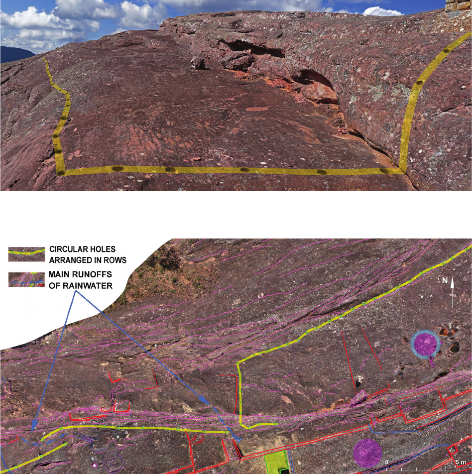
It is worth noting that the line of post-holes on the
northern slope of Samaipata rock is interrupted in two
places. These coincide with specially shaped channels en-
abling rainwater to ow down the slope (Fig. 8). This ob-
servation alone indicates that once, along the line of holes,
there was an articial barrier that allowed for rainwater
runo. This is one of the crucial arguments supporting the
hypothesis postulated by the authors about the existence
of a quincha wall in this place. Based on the preserved
traces, this interpretation seems to be most likely.
As already mentioned, in some places, the line of post-
holes does not run directly on the edge of the articially
carved platforms, but it traverses the slope obliquely to
the contour lines (Figs. 7, 9A). A hypothetical wall placed
along such a line would not protect the platform behind it
from the wind or unwished-for observation from outside.
It seems likely that, between the line of wooden posts and
the steep slope behind it, there was originally a backll
that enlarged the platform above (Fig. 9B). Today, similar
constructions still occur in Bolivia – even in the immedi-
ate vicinity, at the ticket oces at the entrance to Samai-
pata (Fig. 10).
What would a backll enlarging the terrace behind the
quincha wall look like? Except for the round holes for
the posts, there are no traces that could provide guidance.
However, the question can be formulated otherwise – how
would this kind of platform be properly built and do we
know of any examples from the pre-Hispanic era?
Looking at the issue from an engineering point of view,
we have two fundamental problems to solve here: how to
Fig. 5. Contemporary examples of traditional quincha walls (sources:
A – https://urbanscrawldc.files.wordpress.com/2014/07/dsc09652.jpg;
B – https://www.revistatierracultah.cl/?p=12501;
C – https://killpackpanamania.files.wordpress.com/2011/06/p4080190.jpg;
D – https://killpackpanamania.files.wordpress.com/2011/06/p4080227.jpg
[accessed: 17.12.2017])
A
C
B
D
Fig. 6. Main types of pre-Hispanic quincha walls:
A – single-interlaced; B – cross-interlaced;
C – one-sided; D – double-sided (elaborated by A. Kubicka)
Interpretation of traces of hypothetical quincha walls in Samaipata / Interpretacja śladów hipotetycznych ścian quincha w Samaipata 71
prevent the backll from sliding down the slope, and the
problem of backll drainage.
We have ample evidence that Inca builders coped with
such problems perfectly. The most known are probably
the constructions of the terraces on the slopes of Machu
Picchu, where both problems had to be solved simultane-
ously. Admittedly, stone-retaining walls were used there,
not quincha walls as in the case of Samaipata, but the es-
sence of the solution ensuring adequate drainage and sta-
bility of the hopper remains analogous – the bottom layer
consisted of […] larger stones overlain with a layer of
gravel and above that a layer of somewhat sandy material
[13, p. 39, Fig. 5–6]. The use of the lowest layer of bro-
ken stone with sharp edges, especially if the terrace was
founded directly on a steep slope of solid rock, had anoth-
er advantage – it increased the friction between the layers
of the backll and the face of the rock. Such a solution
was observed in the case of the retaining terrace (Fig. 11)
of the Inca astronomical observatory El Mirador de Inka-
raqay [14].
In the case of Samaipata, the application of this engi-
neering knowledge could have resulted in a similar solu-
tion (Fig. 12). It takes into account both the methods of
construction of traditional quincha walls that we know
of, and the principles used by Inca engineers in the con-
struction of terraces. This hypothetical reconstruction
introduces one more element – plant-bre mats laid be-
tween layers of the backll (Fig. 12, item 2). Their func-
tion is analogous to the geotextiles used today. The use of
plant-bre mats is already known from the architecture of
the pre-Inca Wari culture [15]. We can, therefore, assume
that it was also known to the Inca builders.
Fig. 7. The line of post-holes on the northern slope of Samaipata rock (photo by J. Kościuk)
Fig. 8. Hypothetical reconstruction of three sections of the quincha wall on the northern slope of Samaipata rock.
An orthoimage is used as the background (elaborated by J. Kościuk)
72 Janusz Kogut, Jacek Kościuk, Anna Kubicka
Nevertheless, the problem of the lack of shallow ditch
at the base of the wall remains unsolved. However, from
a structural point of view, such a ditch, usually lled with
stones, is mandatory for quincha walls placed directly upon
uncompacted soils. It acts as a foundation, securing the
proper anchoring of piles and evenness of wall settlement,
and ensures adequate tightness at the foot of the wall. In the
case of quincha walls erected directly on solid rock, such
a foundation, and therefore the ditch, is not necessary from
a structural point of view. This may explain the lack of it in
our case. The proposed reconstruction is one of the many
ways in which, at the-then level of building skills, this prob-
lem could have been solved. In summary, it can be said with
a high degree of certainty that the round holes in the rock
(and the posts that were likely once embedded in them)
indicate the existence of a quincha wall in this location.
Nevertheless, the question of the resistance against
wind pressure remains unanswered. An armative an-
swer may render our hypothesis even more credible.
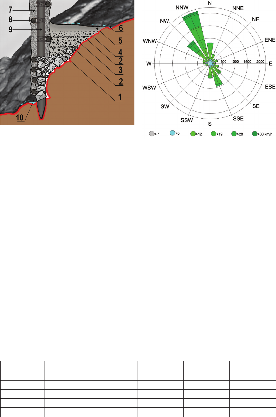
There are no accurate meteorological data for El Fuerte
de Samaipata itself, but the data obtained for the town of
Samaipata indicate the same tendency we observed on
the top of the hill. The predominant winds are those from
a NNW direction; thus, nearly perpendicular to the line of
circular, drilled holes alongside the northern slope of the
rock. The main problem, however, is wind speed. While in
the town located in the valley 300 m below, the wind usu-
ally does not exceed 40 km/h (Fig. 13), it is much strong-
er on the top of Samaipata rock. When working on the
top of the hill, we experienced considerable diculties in
Fig. 10. A contemporary example of a terrace enlargement
with a wooden wall and backfill
(photo by J. Kościuk)
Fig. 11. El Mirador del Inkaraqay (Machu Picchu).
Archaeological sounding showing the construction of the terrace
on a steep slope of the rock. Visible blocks of split stone prevent
the platform from slipping off the slope of the rock
(photogrammetry: J. Kościuk)
Fig. 9. 3D model of a fragment of the northern slope of Samaipata rock:
A – reconstruction of wooden post line; B – hypothetical reconstruction of the backfill behind the post line (elaborated by J. Kościuk)
Interpretation of traces of hypothetical quincha walls in Samaipata / Interpretacja śladów hipotetycznych ścian quincha w Samaipata 73
Fig. 12. Hypothetical reconstruction of the principle of enlarging
the terrace behind the quincha wall: 1 – split stones;
2 – plant-fibre mats; 3 – crushed stone; 4 – compacted earth;
5 – compacted clay; 6 – rainwater drainage channel;
7 – compacted clay with chaff; 8 – drainage at the foot of the wall
(elaborated by J. Kościuk)
Fig. 13. The wind rose for Samaipata town
(source: https://www.meteoblue.com/en/weather /forecast/
modelclimate/samaipata_bolivia_11494517
[accessed: 27.11.2017])
Name
Young
modulus E
[MPa]
Poisson ratio
[–]
Density
[kN/m
3
]
Internal friction angle
[deg]
Cohesion
[kPa]
Sandstone 10000.0 0.3 21.7 40 5000
Clay wall 20.0 0.3 20.0 20 20
Timber 7000.0 0.3 6.0 – –
Infill (clGr) 20.0 0.3 20.0 30 20
Table 1. Mechanical parameters of materials used in the numerical simulation (elaborated by J. Kogut)
maintaining balance during the strongest winds. In a few
cases, gusts of wind almost knocked down the heavy tri-
pod holding our scanner (ca. 24 kg of total weight). Based
on these experiences, wind speed can be estimated to be
up to 90 km/h [16]. This is essential input data for subse-
quent numerical analyses that may ultimately verify our
hypothesis
Numerical modeling of the quincha wall
– input data, material characteristics,
and the simulation model
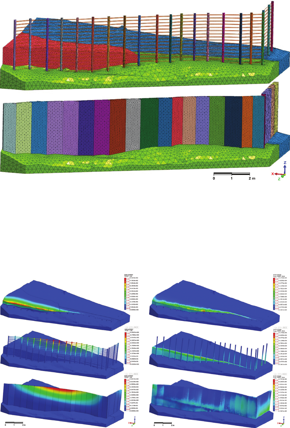
The geometry of the rock was based on data from 3D
laser scanning [17], [18] obtained during the 2016 eld-
work season with a Leica P40 scanner. In 2017, the holes
in the rock were additionally documented with a handheld
Artec Eva scanner, which gave precise data to model how
the wooden posts could t into the rock (Fig. 4). Made-
ra tornillo (Cedrelinga catenaeformis) was chosen as the
material for the vertical posts.
Since there are not any indications pointing to a par-
ticular type of quincha construction, the double-sided wall
(Fig. 6D) was chosen with an inll of clay tempered with
organic cha. Despite this choice, we can only speculate
how the horizontal elements and wattle work were ar-
ranged. Therefore, at this stage of research, it was decided
to model these elements as regular truss elements in order
to model horizontal bracing. The backll that may have en-
larged the platform behind the quincha wall was modeled
with argillaceous gravel (clGr). The intervals between the
posts were adopted in accordance with the results of 3D
laser scanning as 45÷87 cm. Based on the same data, the
diameters of the posts were 12 cm. The tops of the piles
were 1.80 m above the ground on the leeward side
– hence,
due to dierences in slope the posts dier in length.
The mechanical parameters used in our simulation
( Table 1) were based on available literature [7], [19]–[21]
and the authors’ experience. The discrete model was built
in the nite element package Midas [22] and consisted of
50 638 nodes and 228 797 spatial and truss elements re-
sulting in 146 789 equations (Fig. 14). The rock part of
the model was xed at the bottom. The wind impact on the
quincha wall was simulated as a uniform wind load from
the NNW direction with a speed of 25 m/sec.
74 Janusz Kogut, Jacek Kościuk, Anna Kubicka
Discussion of results
The maximum value of the total displacements (Fig. 15)
of the analysed wall scarcely exceeded 3 mm in the worst-
case scenario. The displacements are presented as de-
formed models, separately for the wall, wooden posts, and
Fig. 15. Analyses of total displacements (FEM simulation: J. Kogut)
Fig. 16. Analyses of total strains (FEM simulation: J. Kogut)
Fig. 14. 3D numerical model for FEM analysis (modelled by J. Kogut)
the rock. The rock deformation did not exceed 0.09 mm.
The simulated quincha wall construction proved to be so
exible that it could feasibly survive harsh winds. The
maximum values of the total strains (Fig. 16) can be seen
at the bottom of the quincha wall. The dierences in the
behaviour of the wall are due to the fact that the wall is
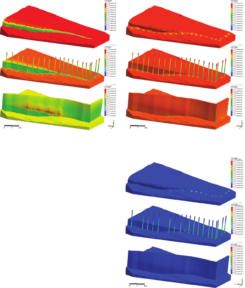
Interpretation of traces of hypothetical quincha walls in Samaipata / Interpretacja śladów hipotetycznych ścian quincha w Samaipata 75
a continuous structure, a part of which has backll that
enlarges the platform behind it. As expected, analyses of
vertical ε
zz
strains in the wooden posts (Fig. 17) showed
that wooden bre on the windward side experienced ten-
sion, while bre on the leeward side was compressed. In
the overall conditions, they were balanced.
It is evident (Figs. 18, 19) that the entire wall, as well
as the rock, was subjected to small stresses, even in such
harsh conditions. As for the rock itself, the maximum
stress value can be seen in the post-holes, but it does
not exceed the strength of the sandstone. The value of
0.5 MPa is well below the threshold value that may de-
stroy the material around the holes.
A closer look at the internal behaviour of the quincha
wall shows that the maximum shear stress is carried by
the posts, and it is a stress level of 0.2 MPa in tension
and 1.5 MPa when compressed. This is even more visi-
ble when the σ
zz
stresses are analysed (Fig. 18). It should
be noted that the compression strength of the wood was
assumed to be equal to R = 21 MPa. Additionally, the hori-
zontal elements of the wall reinforcement did not exceed
a stress level of 0.3 MPa, and torque and bending mo-
ments were negligibly small.
General conclusions
The results obtained on the basis of the FEM simu-
lations allow us to state that the hypothetical quincha
walls should have been able to withstand the assumed
wind loads. The load capacity is so signicant that, even
after any changes in the strength parameters, taking into
account the humidity status of wood and clay, the wall
would still have been stable. It should also be noted that,
Fig. 17. Analyses of ε
zz
strains (FEM simulation: J. Kogut)
Fig. 18. Analyses of total σ
zz
stresses (FEM simulation: J. Kogut)
Fig. 19. Analyses of total Tresca stresses
(FEM simulation: J. Kogut)
in the simulation, a more advanced model was used in
which horizontal elements reinforcing the wall were in-
cluded. It can even be assumed that a lighter type of wall
(for example, one-sided, Fig. 6C), would have also met
the conditions.
The above text is an extended and rewritten version of
our paper presented at the Structural Analysis of Histori-
cal Constructions 2018 Conference in Cusco [23].
76 Janusz Kogut, Jacek Kościuk, Anna Kubicka
Acknowledgements /Podziękowania
The presented work is part of the research sponsored by the grant giv-
en to the Wrocław University of Science and Technology by the Polish
National Science Centre (grant No. 2014/15/B/HS2/01108). Additio-
nally, the municipality of Samaipata, represented by Mayor Falvio Ló
pes Escalera, contributed to this research by providing the accommo-
dation during the eldwork in June and July 2016, as well as in July
2017. The Ministry of Culture and Tourism of Bolivia kindly granted
all necessary permits (UDAM No. 014/2016; UDAM No. 060/2017).
The research was conducted in close cooperation with the Centre for
PreColumbian Studies of the University of Warsaw in Cusco. Spe-
cialists from many other universities and research centres also joined
the project.
Abstract
El Fuerte de Samaipata, commonly known as Samaipata, is an archaeological site in Bolivia. It was inscribed on the UNESCO World Heritage List
in 1998. The most characteristic feature of the site is a natural rock that served as a wak’a (sacred place) for several local, pre-Hispanic cultures, so
its current condition is the result of at least 1200 years of development.
Towards the end of the 20
th
century and beginning of the 21
st
century, Samaipata was comprehensively studied and documented by German scholars.
Due to the threat of progressing erosion, a new documentation project was executed by a Polish team. The main objective of the project was to doc-
ument the vanishing site using 3D laser scanning.
Most of the research already published on Samaipata concentrates on the complex arrangement of niches and terraces, gural and geometrical petro-
glyphs, as well as canals and water reservoirs at the site. The long rows of small circular holes drilled into the rock attract less scholarly attention.
They are commonly associated with the vertical posts used for traditional quincha walls. Since there are doubts about the ability of the quincha wall
to resist the extremely strong winds on the top of the rock, the Authors conducted computer simulations to clarify these reservations. The 3D model
was based on 3D laser scanning results, while FEM was used to solve structural analysis problems.
Key words: Fuerte de Samaipata, Bolivia, rock art, quincha walls, numerical modeling
References /Bibliografia
[1] Nordenskiöld E., Meine Reise in Bolivien 1908–1909, [in:] Globus.
Illustrierte Zeitschrift für Länder- und Völkerkunde, F. Vieweg und
Sohn, Braunsweig 1910, 213–219.
[2] Pucher L., Ensayo sobre el arte prehistórico de Samaypata, “Re-
vista de la Universidad de San Francisco Xavier”, Universidad
Mayor de San Francisco Xavier Sucre, Sucre 1945, 17–61.
[3] Trimborn H., Der skulptierte Berg von Samaipata, “Archäologi-
sche Studien in den Kordilleren Boliviens”, Bd. 3, “Baessler Ar-
chiv, Beiträge zur Völkerkunde” 1967, NF 5, 130–169.
[4] El Fuerte de Samaipata. Estudios arqueo lógicos, A. Meyers,
I. Combès (comp.), Biblioteca del Museo de Historia Universidad
Autónoma Gabriel René Moreno, Santa Cruz de la Sierra 2015.
[5]
Santo Tomas, Lexicon ó Vocabulario de la Lengua General del Perú,
Valladolid 1560, https://archive.org/stream/lexiconovocabula
00domi#
page/n357/mode/2up/search/kincha [accessed: 13.08.2019].
[6] La Quincha, https://vimeo.com/69103674 [accessed: 12.08.2019].
[7] Quinn D., D’Ayala D., In-plane experimental testing on historic
quincha walls, [in:] F. Peña, M. Cháve (eds.), SAHC 2014: 9
th
In-
ternational Conference on Structural Analysis of Historical Con-
structions, Institute of Engineering, UNAM, Mexico City 2014,
http://www.hms.civil.uminho.pt/sahc/2014/topic02-fullpaper007.
pdf [accessed: 11.07.2019].
[8] Minke G., Manual de construcción para viviendas antisísmicas de
tierra, Forrschunglabor für Experimentelles Bauen, Universidad de
Kassel, Alemania 2001, 26–27.
[9] Carbajal F., Ruiz G., Schexnayder C.J., Quincha Construction
in Perú, “Practice Periodical on Structural Design and Construc-
tion” 2005, Vol. 10, Iss. 1, 56–62, doi: 10.1061/(ASCE)1084-0680
(2005)10:1(56).
[10] Beck H.E., Zimmermann N.E., McVicar T.R. et al., Present and
future KöppenGeiger climate classication maps at 1km resolu-
tion, “Scientic Data” 2018, Vol. 5, 180214, doi: 10.1038/sdata.
2018.214 [accessed: 21.01.2019].
[11]
Guía práctica. Construyendo viviendas con Quincha Mejorada, Lima
2008, http://www.predes.org.pe/predes/manual_quincha_mejorada.pdf
[accessed: 15.06.2019].
[12] Gutiérrez A.D., Sistema constructivo “quincha prefabricada”, “In-
formes de la Construcción” 1984, Vol. 36, No. 361, 25–34, http://
informesdelaconstruccion.revistas.csic.es/index.php/informesdela-
construccion/article/view/1962/2163 [accessed: 23.01.2019].
[13] Machu Picchu: A Civil Engineering Marvel, K.R. Wright, A.V. Ze-
garra, R.M. Wright, G.D. McEwan (eds.), ASCE Press, USA, 2000.
[14] Astete Victoria F., Ziółkowski M., Kościuk J., On Inca astro-
nomical instruments: the observatory at Inkaraqay – El Mirador
(National Archaeological Park of Machu Picchu, Peru), “Estudios
Latinoamericanos” 2016/2017, Vol. 36/37, 9–25.
[15] Giersz M., Castillo de Huarmey. Un centro del imperio Wari en la
costa norte del Perú, Ediciones del Hipocampo, Lima 2017.
[16] http://www.naukowiec.org/tablice/geograa/skala-beauforta--ska-
la-sily-wiatru_2763 [accessed: 12.11.2018].
[17] Kogut J., Pilecka E., Szwarkowski D., Analysis of landslide eects
along a road located in the Carpathian ysch, “Open Geosciences”
2018, Vol. 10, Iss. 1, 517–531, doi: 10.1515/geo-2018-0041.
[18] Kościuk J., Modern 3D scanning in modelling, documentation and
conservation of architectural heritage, [in:] J. Jasienko (ed.), Struc-
tural Analysis of Historical Constructions, SAHC2012 – 8
th
Inter-
national Conference on Structural Analysis of Historical Construc-
tions, Dolnośląskie Wydawnictwo Edukacyjne, Wroclaw 2012,
64–76.
[19] Vicente E.F., Torrealva D.E., Mechanical properties of adobe
masonry of historical buildings in Peru, [in:] F. Peña, M. Chávez
(eds.), SAHC2014 – 9
th
International Conference on Structural
Analysis of Historical Constructions Mexico City, Mexico, 14–17
October 2014, Mexico City 2014, http://www.hms.civil.uminho.pt/
sahc/2014/topic10-fullpaper005.pdf [accessed: 14.05.2019].
[20] Morton T., Stevenson F., Taylor B., Smith N.C., Low Cost Earth
Brick Construction, Arc, Auchtermuchty 2005.
[21] Quinn N., D’Ayala D., Moore D., Experimental testing and nu-
merical analysis of quincha under lateral loading, [in:] J. Jasienko
(ed.), Structural Analysis of Historical Constructions, SAHC2012
– 8
th
International Conference on Structural Analysis of Historical
Constructions, Dolnośląskie Wydawnictwo Edukacyjne, Wroclaw
2012, 1699–1708.
[22] Midas FEM, http://midasnfx.com/ [accessed: 10.12.2017].
[23] Kościuk J., Kogut J., Numerical modelling of hypothetical quincha
walls on Samaipata Rock, [in:] R. Aguilar et al. (eds.), Structural
analysis
of historical construction: an interdisciplinary approach,
Sprin ger, [s. l.]
2019, 835–843, doi: 10.1007/978-3-319-99441-3_90.
Interpretation of traces of hypothetical quincha walls in Samaipata / Interpretacja śladów hipotetycznych ścian quincha w Samaipata 77
Streszczenie
El Fuerte de Samaipata jest stanowiskiem archeologicznym w Boliwii wpisanym na Listę Światowego Dziedzictwa UNESCO w 1998 r. Najbardziej
charakterystyczną cechą tego miejsca jest naturalna skała, która służyła jako wak’a (święte miejsce) dla kilku lokalnych kultur prehiszpańskich, więc
jej obecna forma jest wynikiem co najmniej 1200 lat rozwoju.
Pod koniec XX w. i na początku XXI Samaipata była wszechstronnie badana i dokumentowana przez niemieckich uczonych. Ze względu na postępu-
jącą erozję polski zespół wykonał nowe pomiary, których głównym celem była precyzyjna rejestracja zagrożonych reliktów za pomocą laserowego
skanowania 3D.
Większość dotychczas opublikowanych wyników badań na temat Samaipata koncentruje się na złożonym zespole nisz i tarasów, guralnych i geome-
trycznych petroglifów, a także kanałów i zbiorników wodnych rzeźbionych w skale. Długie rzędy małych okrągłych wywierconych otworów przycią-
gają mniej uwagi naukowców. Są one powszechnie kojarzone z pionowymi słupkami stosowanymi do tradycyjnych ścianek quincha. Wątpliwości co
do wytrzymałości ścianki quincha na ekstremalnie silne wiatry na szczycie skały skłoniły autorów tego artykułu do przeprowadzenia komputerowych
symulacji w celu wyjaśnienia tych zastrzeżeń. Model 3D został oparty na wynikach skanowania laserowego 3D, a samą analizę przeprowadzono
z wykorzystaniem metody elementów skończonych (MES).
Słowa kluczowe: Fuerte de Samaipata, Boliwia, sztuka naskalna, ścianki quincha, modelowanie numeryczne