2020
2(62)
DOI: 10.37190/arc200212
Introduction
El Fuerte de Samaipata is a pre-Hispanic archaeologi-
cal site in Bolivia, in the province of Florida and the de-
partment of Santa Cruz, on the eastern slopes of the An-
des at an altitude ca. 1890–1925 m. Due to its historical
and cultural value, the site was inscribed on the UNESCO
World Heritage List in 1998.
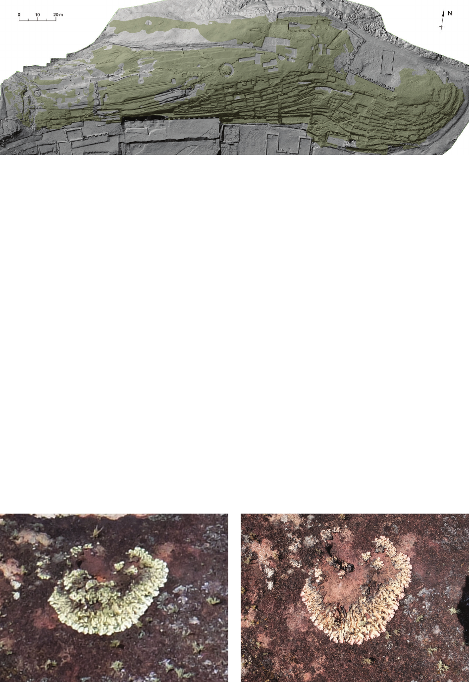
The entire archaeological site covers about 40 hectares
and consists of two main parts:
– An administrative and ceremonial complex of ca. 50
buildings typical of provincial Incan architecture located
in the southern part of the site;
– A natural rock (ca. 80 × 250 m) towering over the Pi-
ray valley in the northern part of the site.
The natural rock was the main subject of the project
“Architectural examination and complex documentation
of Samaipata (Fuerte de Samaipata/Bolivia) site from the
World Heritage List”, of which this study is a small excerpt.
Wojciech Bartz*, Jacek Kościuk**, Maria Gąsior***,
Teresa Dziedzic****
Petrographic, mineralogical, and climatic analyses, and risk maps
for conservation strategies
Analizy petrograficzne, mineralogiczne i klimatyczne oraz mapy ryzyka
dla strategii konserwatorskiej
The whole rock is densely covered with a complex
arrangement of terraces, platforms, water reservoirs, and
channels. Between them are numerous petroglyphs de-
picting animals or geometric forms. The present form of
the rock is the result of the activities of various local cul-
tures over almost 1200 years, who treated the rock as a sa-
cred place (wak’a). However, Incan characteristics clearly
dominated this rock after it was incorporated into the Inca
Empire (Tawantinsuyu) in the 2
nd
half of the 15
th
century.
Apart from the 16
th
century mentions by Spanish chro-
niclers [1] and a short description from the 1
st
quarter of
the 19
th
century by Alcide Dessaline d’Orbigny [2], the
site only became a subject of systematic scientic interest
in the 20
th
century [3], [4]. The range of studies signi-
cantly increased in 1970 due to the establishment of the
Archaeological Research Centre in Samaipata [5] and re-
search by German scholars [6]–[11].
Outline and main aim of the study
In the last quarter of the 20
th
century, intensive research
combined with the removal of vegetation growing on the
rock and the accumulated organic layers led to the expo-
sure of the entire ridge of the rock (Figs. 1A, B). This
not only enabled detailed research to be conducted on
previously unavailable parts of the whole complex, but
also contributed to the popularisation of El Fuerte as an
important tourist attraction.
The acceleration of rock erosion was an unforeseen
side eect of this exposure. The rapidly progressing ero-
* ORCID: 0000-0002-7267-2776. Institute of Geological
Sciences, University of Wrocław, e-mail: wojciech.bartz@uwr.edu.pl
** ORCID: 0000-0003-0623-8071. Faculty of Architecture,
Wro c ław University of Science and Technology.
*** ORCID: 0000-0002-9152-3792. Ceramics and Glass Con-
servation and Restauration Department, Eugeniusz Geppert Academy of
Art and Design in Wroclaw.
**** ORCID: 0000-0003-2855-0074. Faculty of Architecture,
Wrocław University of Science and Technology.
136 Wojciech Bartz, Jacek Kościuk, Maria Gąsior, Teresa Dziedzic
sion of the rock makes petroglyphs less and less clear, and
some are no longer recognisable.
The rst attempts to address the problem of erosion go
back to the beginning of the 21
st
century, but the prob-
lem is complicated due to the nature and the size of the
rock itself, and it has not yet been satisfactorily resolved.
Research has focused mainly on mineralogical and pe-
trographic analyses of the rock and nding suitable con-
solidators, recipes for putties to seal natural cracks, and
methods to stop the spread of mosses, lichens, and algae
[12]. Much less attention has been paid to a holistic view
of the problem, and in particular to determining all risk
factors conducive to erosion and drawing up risk maps
identifying the most vulnerable areas requiring immedi-
ate conservation intervention. This subject, in addition to
complementary mineralogical and petrographic research,
is the main topic of this study.
Methodology and methods
Apart from anthropogenic factors, the most signicant
reasons for the progressing erosion of the rock are climat-
ic and biological hazards. Depending on the rock proper-
ties and susceptibility to individual threats, each of these
factors will interact with the rock dierently. Therefore, it
is important to thoroughly understand all the properties of
the rock – physical, chemical, and mineralogical, and at
the same time to identify all risk factors.
The methodology adopted in these studies was to ex-
amine each of these factors separately, and then to analyse
the obtained results to understand how they interact. Cli-
matic factors directly aecting the rock include aeolian
processes (wind erosion), thermal shock eects, and pre-
cipitation. Biological factors include the eects of plant
vegetation and the spreading of lichens and algae. The
shape of individual parts of the rock also needs to be con-
sidered – this can either intensify the eects of risk factors
or minimise them. Particularly important is the inclination
of slopes and their orientation towards cardinal compass
directions, areas of natural and anthropogenic inltration
of rainwater (cracks, holes, etc.), zones of permanent ac-
cumulation of rainwater (articial reservoirs and natural
depressions), zones of water euence, and deposits of
organic material favourable for plant vegetation. Due to
this, accurate data obtained by 3D laser scanning of the
whole rock
1
and photogrammetric documentation
2
has
been very important.
Analysis of the current state
of erosion
The mutual interaction of all risk factors and the local
properties of heterogeneous sedimentary rock has resulted
in dierent types of erosion – peeling, cracking, exfolia-
tion, and powdering. During the two seasons of eldwork
(2016, 2017), the main stages of erosion and areas of oc-
currence were identied.
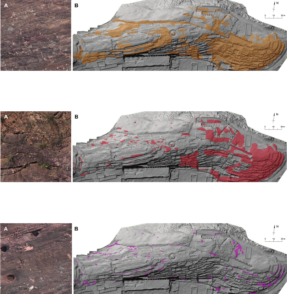
The rst stage of erosive phenomena is micro-cracks
appearing on the rock surface (Fig. 2A). Their presence
can potentially be associated with thermal shock and the
alternation between the soaking and drying of porous
rock. Practically, 50% of the Samaipata rock surface is
covered with such micro-cracks (Fig. 2B).
1
Cf. J. Kościuk, B. Ćmielewski, M. Telesińska, A. Kubicka, 3D
terrestrial laser scanning of El Fuerte de Samaipata , in the same issue
of “Architectus”.
2
B. Ćmielewski, I. Wilczyńska, C. Patrzałek, J. Kościuk, Digital
close-range photogrammetry of El Fuerte de Samaipata, in the same
issue of “Architectus”.
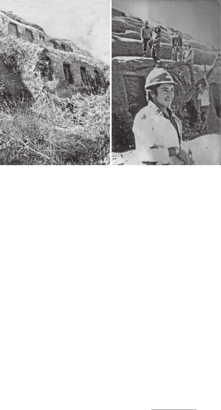
A B
Fig. 1. The southern slope
of the rock:
A – during the time of research
by Erland Nordenskiöld
(around 1923)
(photo from archives
of the Samaipata Archaelogical
Research Centre);
B – in April 1974
(photo courtesy of Damielo
Montenegio Fernández)
Petrographic,mineralogical,climaticanalyses,riskmaps / Analizypetrograficzne,mineralogiczne,klimatyczne,mapyryzyka 137
The second observed erosion stage, especially where
the natural stratication of the rock is oblique in relation
to its surface, is exfoliation – individual layers separate
from the bedrock (Fig. 3A). Exfoliation processes are ac-
celerated by the presence of vegetation whose root sys-
tem penetrates and breaks existing micro-ssures. It is
estimated that about 25% of the entire rock surface is at
risk of exfoliation (Fig. 3B). A strong correlation is visible
between the zones of micro-cracks and the zones where
the surface layers of the rock are exfoliating.
In the third stage of erosion, detached fragments of rock
completely lose contact with the ground and begin to move
(Fig. 4A). The progression of this process causes their fur-
ther fragmentation into ever smaller pieces that are easily
moved by rainwater and wind. Accumulating deposits of
such material, additionally enriched with organic particles
blown by the wind, are an excellent breeding ground for
growing plants whose root system will penetrate the rock
deeper and deeper. Zones in which loose lithic material is
deposited (Fig. 4B) are increasing every year.
Climatic and topographical factors
El Fuerte de Samaipata is located in the southern hem-
isphere at 18° latitude – in the zone between the equator
and the Tropic of Capricorn. This fact is essential for con-
sidering the impact of climatic factors on possible conser-
vation hazards, mainly since the main ridge of the rock
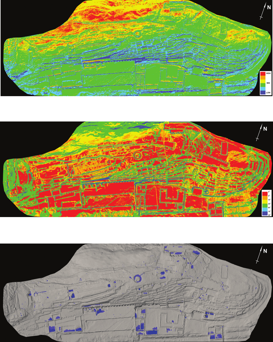
Fig. 2. First stage of erosion:
A – an example of the first phase of erosion (micro-craks) on 0.3 mm-resolution orthoimage (photo by J. Kościuk);
B – areas of numerous micro-cracks in the lithic surface (elaborated by T. Dziedzic)
Fig. 3. Second stage of erosion:
A – an example of the second phase of erosion (exfoliation) on 0.3 mm-resolution orthoimage (photo by J. Kościuk);
B – areas of exfoliation of the lithic surface (elaborated by T. Dziedzic)
Fig. 4. Third stage of erosion:
A – an example of the third phase of erosion (loose fragments of the rock lying on the surface) on 0.3 mm-resolution orthoimage (photo by J. Kościuk);
B – zones of loose lithic material (elaborated by T. Dziedzic)
138 Wojciech Bartz, Jacek Kościuk, Maria Gąsior, Teresa Dziedzic
is latitudinally oriented. Strong rays of sun heat both the
northern and the southern slope of the hill. The combina-
tion of this with the 24-hour cycle of temperature changes
and cold winds creates the risk of thermal shock. Identi-
cation of areas where such risk may occur was, therefore,
a priority for this study.
The rst step in this type of analysis was to determine
which fragments of the complex surface of the rock are
most exposed to sunlight. These types of calculations are
usually carried out to determine the energy balance of
a building, or to assess the possibility of using photovolta-
ic cells. Software for this kind of simulation, for example,
EnergyPlus, uses integrated meteorological data – EPW
les that contain information about the temperature and
intensity of solar radiation (direct and diused). However,
there is no weather station on El Fuerte de Samaipata or
even in the town of Samaipata itself; hence, there is no de-
tailed meteorological data for this place that would allow
cumulated solar energy to be calculated. The problem had
to be solved dierently.
In our case, we were not interested in the absolute val-
ues of accumulated solar energy expressed in W • h/m
2
, but
only the relative dierences in the insolation of individu-
al parts of the rock. Therefore, instead of calculating the
energy balance, a virtual 3D model of the whole hill was
used. The model was embedded in the virtual 3D space
according to geographical coordinates and correctly ori-
ented towards north. The two most opposing moments of
the solar year were selected – summer solstice (21
st
June)
and winter solstice (21
st
December). At equal intervals
corresponding to daylight hours, ten visualisations were
rendered for 21
st
June (Fig. 5) and twelve for 21
st
Decem-
ber
(Fig. 6). The rendering tool used was Bentley Micro-
Station V8i software (version 08.11.09.459), which ena-
bles the realistic visualisation of solar lighting according
to geographical location and specic date. The values of
the horizontal and vertical angles of incidence of sunlight
were additionally veried using Stellarium software (ver-
sion 0.16.0). As a rendering algorithm, ray tracing was
selected, which also includes diused light and ground
reection for skylight, as well as cloud cover (cloudless
conditions were selected) and air transparency (due to the
high humidity of air in this region of Bolivia, the option
“rural” was chosen).
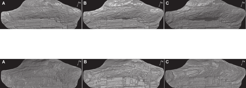
Grey-scale visualisations for individual hours of day-
light were then stitched together into one image, separate-
ly for 21
st
June and 21
st
December, and the resulting im-
ages were divided into six classes of grey. Each of the grey
classes was assigned one of six basic colours from red for
the most illuminated surfaces throughout the whole day,
to blue for those that remain mainly in the shadows. In this
way, maps were obtained showing to some extent which
fragments of the rock could have warmed up the most at
these two dierent moments of the year (Figs. 7, 8), so
zones in which one could expect thermal shock due to the
rapid temperature changes between day and night.
During our stay on El Fuerte in June–July 2016 and
2017, we repeatedly experienced such temperature jumps.
At the end of the workday, the rock was heated in many
places to almost 40 °C, while the next morning it was cov-
ered with frost and ice.
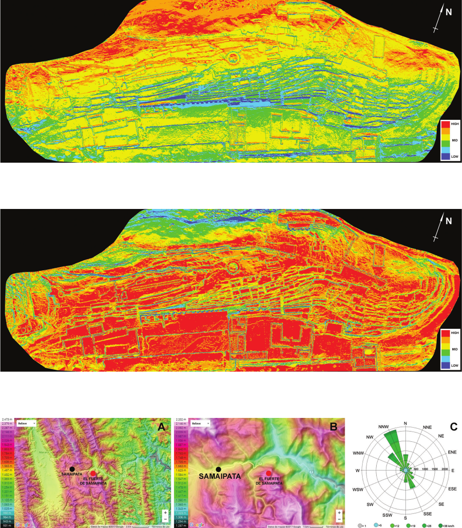
The eect of thermal shock is intensied by strong
winds blowing over El Fuerte. The specicity of the ter-
rain, with its parallel ranges of mountains and valleys
(Figs. 9A, B), means that NNW winds dominate there
(Fig. 9C).
Precipitation is another essential factor from the point
of view of conservation hazards. The annual rainfall for
the nearby town of Samaipata reaches 1000 mm – for
comparison, this is almost twice as much as for London.
For El Fuerte, located nearly 300 m higher than the town,
annual rainfall is undoubtedly even higher, but detailed
meteorological data are not available.
The virtual 3D model of the rock was used again to
simulate the inuence of wind on the eect of thermal
shock. The model was illuminated from a NNW direction
(335° from the north) and rendered using the same soft-
ware. In this way, the most illuminated parts of the hill
simulated the surfaces most exposed to the wind, and thus
those that cooled down the fastest (Fig. 10). This chart is
also an approximate image of the zones where wind ero-
sion eects may occur.
Fig. 5. Samples of visualisations of the rock insolation on 21
st
June for the fourth (A), sixth (B), and eight (C) hour of daylight
(elaborated by J. Kościuk)
Fig. 6. Samples of visualisations of the rock insolation on 21
st
December for the fourth (A), sixth (B), and eight (C) hour of daylight
(elaborated by J. Kościuk)
Petrographic,mineralogical,climaticanalyses,riskmaps / Analizypetrograficzne,mineralogiczne,klimatyczne,mapyryzyka 139
Threats related to atmospheric precipitation are two-
fold. Rainwater that accumulates on the rock surface for
a long time causes hydrolysis and the subsequent wash-
ing-out of the binder of the sandstone rock. If the temper-
ature drops below 0 °C, water freezing in the rock crevices
will break them. Fortunately, the months with the highest
rainfall (December to March) are also the warmest, when
the temperature usually does not fall below freezing point.
In both cases, however, the decisive factor inuencing the
possible retention of rainwater is the inclination of the
slope and the occurrence of local depressions.
Fortunately, one of the thematic styles of displaying
3D objects in Bentley MicroStation V8i is slope inclina-
tion. With this, as in all previous cases, the results were
divided into six classes using a colour scale in which the
red corresponded to surfaces where the inclination did not
exceed 8°, and the blue meant a slope greater than 75°
(Fig. 11).
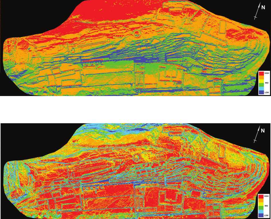
Fig. 7. Rock insolation on 21
st
June (elaborated by J. Kościuk)
Fig. 8. Rock insolation on 21
st
December (elaborated by J. Kościuk)
Fig. 9. The topographical situation of El Fuerte de Samaipata (A and B) and the wind rose (C)
(sources: http://suncalc.net; https://www.meteoblue.com/en/weather/forecast/modelclimate/samaipata_bolivia_11494517 [accessed: 12.01.2018])
140 Wojciech Bartz, Jacek Kościuk, Maria Gąsior, Teresa Dziedzic
Fig. 10. Exposure to the prevailing wind direction (elaborated by J. Kościuk)
Fig. 11. Slope inclination analysis (elaborated by J. Kościuk)
Fig. 12. Depressions without drainage (elaborated by J. Kościuk)
Local depressions were also searched for in the Bentley
MicroStation V8i environment – contour lines were gen-
erated every 10 cm and those that formed enclosed areas
were selected (Fig. 12). The results were presented this
time in a dierent colour scale. The results of all these
partial analyses were further used to prepare risk maps for
conservation strategies.
Biologically inducted erosion
In addition to the climatic and topographic aspects men-
tioned above, biological factors also promote rock erosion.
The scope of the entire project did not include genetic test-
ing, which would have required the separate consent of the
Bolivian Ministry of the Environment. Biological factors
Petrographic,mineralogical,climaticanalyses,riskmaps / Analizypetrograficzne,mineralogiczne,klimatyczne,mapyryzyka 141
have also already been the subject of partial studies conduct-
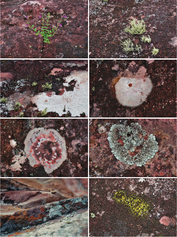
ed by Sonia Avilés [12]– [14]. Nevertheless, numerous plants
growing on the rock, as well as lichens, mosses and algae
(Fig. 13), distract not only for aesthetic reasons, but mainly
due to their impact on erosion. This impact is not only the al-
ready mentioned process of breaking micro ssures by pen-
etrating plant roots, but also the biodegradation of the binder
of the ne sandstone particles, which is even more invasive.
Mineralogical and petrographic analyses
Mineralogical analyses were done for 10 samples taken
from the Samaipata rock and one sample of locally occurring
clay material that is used for restoration and lling cavities
in the Samaipata rock. The rock material was split into two
portions with a stone cutting saw. Afterwards, all samples
were laboratory dried at temperature of ca. 40 °C, to a con-
stant weight. The rst halves were impregnated with a low
viscous epoxy-resin under vacuum conditions and used for
the preparation of a petrographic thin section according to
procedure described by Jan Elsen [15]. Petrographic analyses
were performed using a Zeiss Axiolab polarising microscope.
The second halves were analysed by means of
– powder X-ray diraction (XRD);
– thermal analysis (DSC-TG);
– scanning electron microscopy (SEM-EDS).
In the latter case, analyses were performed for two rep-
resentative samples (polished thin sections, 30 nm carbon
coat) chosen on the basis of petrographic observation.
A Jeol JSM IT-100 scanning electron microscope (SEM)
equipped with an Oxford EDS system operating at an ac-
celeration voltage of 16 kV was used.
XRD and DSC-TG analyses were done on a sieved frac-
tion of <63 μm that mostly contained rock cement. XRD
measurements were taken with a Siemens D 5005 dif-
fractometer, using Bragg–Brentano geometry and Co Kα
Fig. 13. Examples of various forms
of plants, lichens, fungi, and algae
growing on the rock surface
(photo by J. Kościuk)
142 Wojciech Bartz, Jacek Kościuk, Maria Gąsior, Teresa Dziedzic
radiation, in the 2Theta range 4÷75 deg. DSC-TG analy-
sis was carried out with a PerkinElmer STA 6000 thermal
analyser, from 40 °C up to 999 °C, at a constant heating
rate of 15 °C/min in N
2
atmosphere.
The sample of the locally occurring clay was powdered
and suspended in ca. 500–700 ml of distilled water. After-
wards, it was allowed to settle gravitationally (12 hours)
to sediment most of the particles not part of the clay frac-
tion (greater than ca. 4 µm in diameter). Subsequently, the
cloudy supernatant was siphoned and then centrifuged at
5000 rpm for 10 min. The obtained centrifuged sediment
was used to prepare three oriented mounts. For each one,
a few drops of the suspended clay sample were placed onto
a slide using a pipette, and the slides were left to dry. Finally,
the rst slide was saturated with ethylene glycol, the second
one was heated for one hour at 550 °C, and the last one was
left untreated. XRD measurements were made using a B
Siemens D 5005 diractometer with Bragg–Brentano geo-
metry and Co Kα radiation in the 2Theta range 4÷35 deg.
Results and discussion
The research was intended not only to identify the
sources of conservation risks, but also to determine their
potential scope. To this end, a number of risk maps were
developed, and physicochemical, mineralogical, and pe-
trographic analyses were used to characterise the local
sandstone and determine its weak points.
Climatic and topographical analyses
The juxtaposition of insolation data (Figs. 7, 8) with
simulations of exposure to prevailing winds (Fig. 10) de-
termined the zones for which there is the greatest risk of
thermal shock. For the June solstice, these are main ly the
northern slopes of the hill and all surfaces of niches, ter-
races, and platforms with northward exposure (Fig. 14).
It should be clearly stated here that the presented
risk scales do not use absolute values. This is particu-
larly important when comparing June data with Decem-
ber data. The risk of negative temperatures on El Fuerte
appears mainly in June, July, and August, and these are
the months in which the lowest maximum temperatures
are recorded. Together with September, this is also the
period of the strongest winds. Temperatures dropping be-
low zero and strong winds are the two most important
factors for the risk of thermal shock during this period
of the year.
Fig. 14. Risk of thermal shock on 21
st
June (elaborated by J. Kościuk)
Fig. 15. Risk of thermal shock on 21
st
December (elaborated by J. Kościuk)
Petrographic,mineralogical,climaticanalyses,riskmaps / Analizypetrograficzne,mineralogiczne,klimatyczne,mapyryzyka 143
Risks of thermal shock for the December solstice are
completely dierent. Mainly all horizontal surfaces are
threatened, and on slopes, even southern ones, the risk is
much lower (Fig. 15).
In turn, mid-November to mid-March is a period when
the minimum temperature does not fall below zero. The
winds are also much weaker, but the maximum temper-
atures are among the highest in the year. An important
factor is also the dierence in the angle of incidence of
sunlight. From November to March, at these latitudes, in
the middle of the day, the sun’s rays fall almost perpen-
dicularly, so all horizontal surfaces heat up much more
strongly. Risk levels dened as “high” for June and De-
cember are therefore hardly comparable.
The risk of thermal shock is not the only threat to El
Fuerte. The previous section also specied the impact of
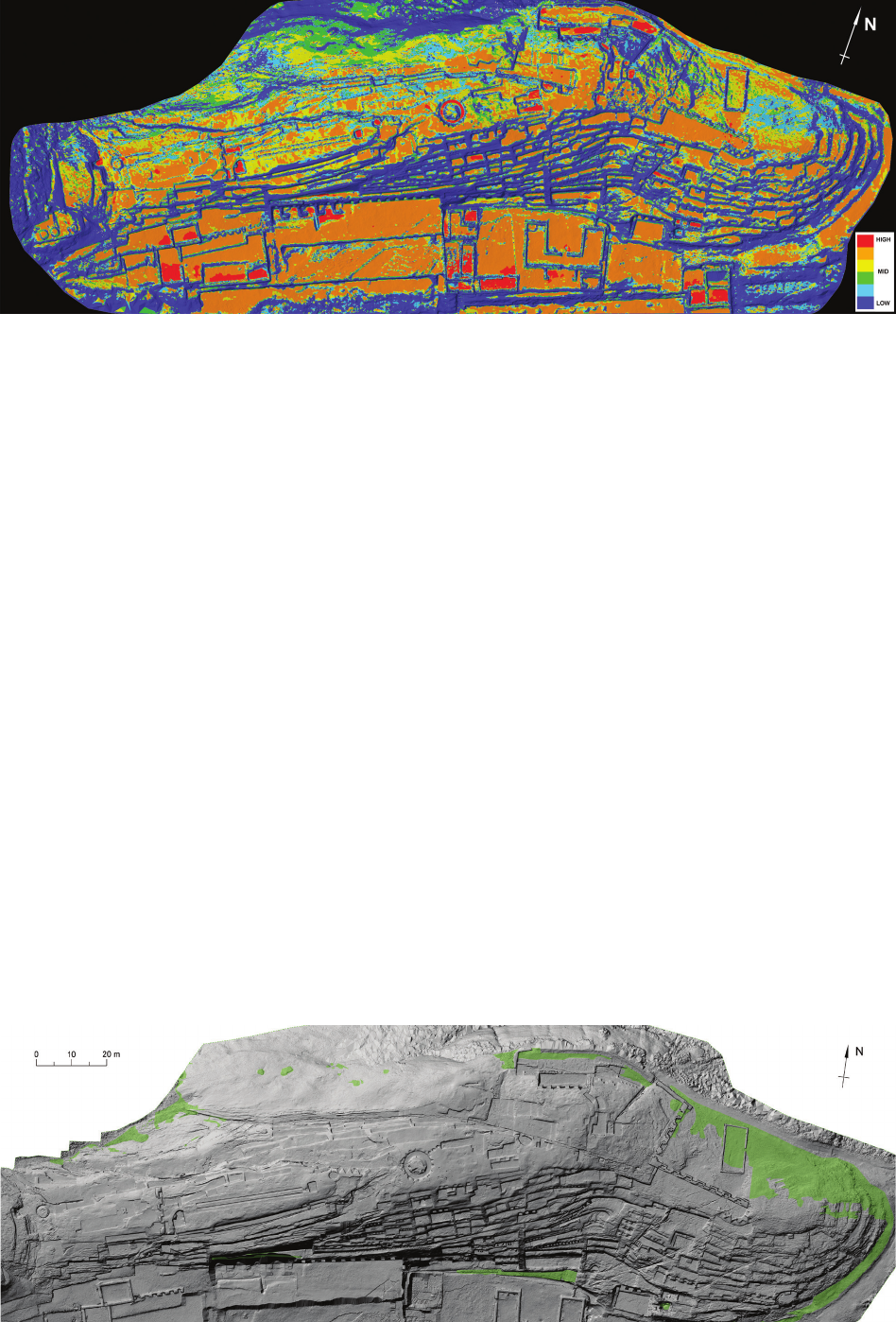
wind erosion (Fig. 10), slope inclination (Fig. 11), and lo-
cal depressions (Fig. 12). Summing up these four factors
gives us a full picture of the threats caused by climatic
factors and the site topography. The resulting map of ac-
cumulated risk factors (Fig. 16) indicates that, apart from
local depressions that were already discussed separately,
the most negative factors add up on all horizontal areas.
Therefore, from this point of view, conservation priorities
should focus on these areas, and particularly on all petro-
glyphs located there. This, however, does not exhaust the
list of all hazards regarding El Fuerte.
Biologically induced erosion
El Fuerte de Samaipata is a red sandstone rock with
high porosity. It contains iron compounds, which aect
both its colour and resistance to weathering. It is a rock
uplift exposed to destructive atmospheric factors: chemi-
cal, mechanical, and physical. Most processes are initiated
in the presence of water in various forms (rainfall, fog,
and condensation). Wind and associated abrasion process-
es are also highly destructive.
All these factors aect the intensive weathering of the
rock. There are deep cracks in sandstone in many places. The
largest run diagonally from the north-west to the south-east.
The rock is covered with reliefs of varying heights.
Due to the presence of articial (reliefs with symbolic
decoration) and natural depressions, there are numerous
deposits where water, loose rock fragments, and organic
material deposited by the wind collect. The accumulation
of humidity and organic material creates favourable con-
ditions for the development of lichens, and as a conse-
quence of their soil-forming activity, also the growth of
higher vegetation and mosses (Fig. 17). These plants are
Fig. 16. Accumulated risk factors: slope inclination, depression, thermal shock, wind erosion (elaborated by J. Kościuk)
Fig. 17. Green plant zones (elaborated by T. Dziedzic)
144 Wojciech Bartz, Jacek Kościuk, Maria Gąsior, Teresa Dziedzic
strongly rooted. Attempts to remove them can damage the
rock, and root expansion leads to the cracking and break-
ing of the rock.
The growth of numerous types of fungi, algae, and li-
chens including Lecanora, Cladonia, Aspicilia, Xantho-
ria, and Rhizocarpon is observed on most of the rock sur-
face (Fig. 18). Lichens cause moisture in the sandstone to
be retained, create colourful spots on the entire surface of
El Fuerte, and the acids they produce cause rapid progres-
sive chemical erosion of the rock [16].
Lichens have a particularly destructive eect, as they
form spots that are crusty and very sti. Their presence
causes not only drastic colour changes, but also the trans-
formation of the stone structure and, as a consequence,
the powdering and aking of the surface attacked by
them. This type of lichen is observed on the surface of
El Fuerte in the northern part, and is particularly abun-
dant in one of the most valuable parts of the monument
– within the relief that depicts the “Big Snake” (the rattle-
snake) and on the surface of what is known as the “Choir
of Priests”.
On the surface of the El Fuerte rock, there are also rel-
atively numerous traces of vandalism. These are mainly
inscriptions carved in rock of various sizes and locations.
Fortunately, since the introduction of restrictive regula-
tions that prohibit climbing on the rock, such activities are
no longer recorded.
The greatest damage is observed in the eastern and
southern parts of the rock. Damage in the eastern part
is mainly caused by exposure to wind and abrasion and
rainwater and its associated washing and rinsing of the
sandstone surface. In the southern part, the vertical sur-
face of the rock is destroyed, which is probably related to
the action of water accumulating in the rock structure and
just leaking on the southern slope of the hill.
On the northern slope of the rock, in a place invisible
to visitors, next to similar samples already made by Sonia
Avilés, an attempt was made to mechanically clean the
surface of the rock from lichens, fungi, and algae using
soft brushes and distilled water. The cleaned surface was
impregnated with Biotin biocide 40% (solution in a mix-
ture of ethyl and isopropyl alcohol).
The next test was carried out on a crude, lichen-cov-
ered piece of rock, which was impregnated with Biotin R
biocide alcohol solution (manufactured by CTS, Italy) in
various concentrations: 10%, 20%, and 40%.
It was observed that the application of Biotin R caused
the decay of lichens at the site (Figs. 19, 20). The eect
Fig. 18. Zones of intensive occurrence of lichens, fungi, and algae (elaborated by T. Dziedzic)
Fig. 19. Prior to application of 40% solution of Biotin R
(photo by M. Gąsior)
Fig. 20. Seven days after application
(photo by M. Gąsior)
Petrographic,mineralogical,climaticanalyses,riskmaps / Analizypetrograficzne,mineralogiczne,klimatyczne,mapyryzyka 145
was dependent on the concentration applied – the higher
the concentration, the more eective the decay. Unfortu-
nately, within a short period of time, it was found that the
disinfected area of the rock was quickly inhabited by other
lichen specimens. This is a natural process – the special
agent used did not restrain the growth for much longer.
It should also be mentioned that disinfection of the
whole rock would require the use of a signicant amount of
chemicals, which would not be without impact on the natu-
ral environment. These types of actions can possibly be rec-
ommended only to protect the most valuable petroglyphs.
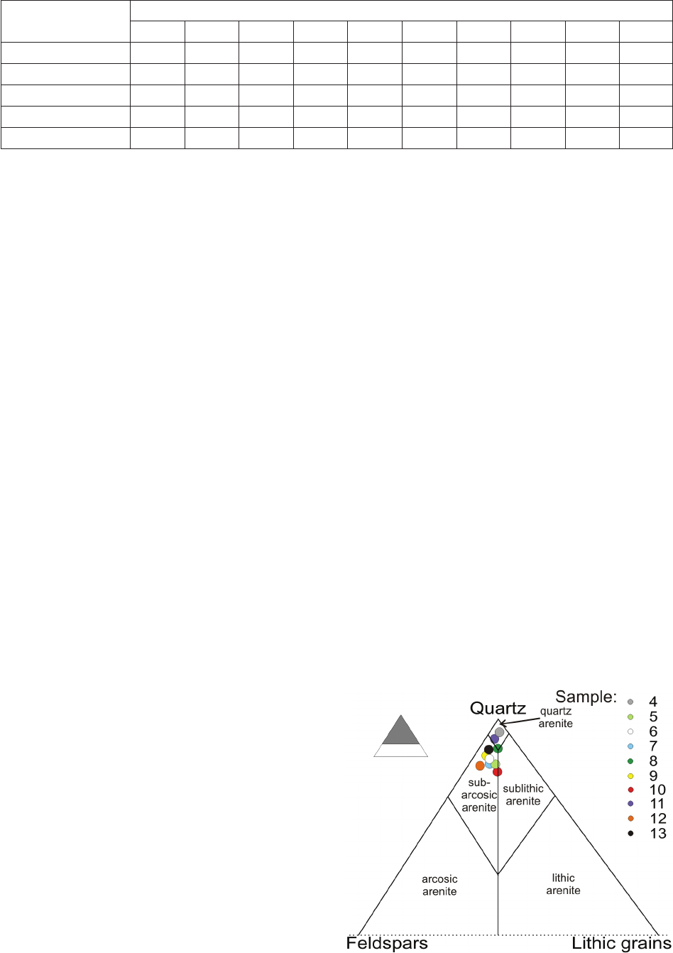
Petrographic and mineralogical analyses
Mineralogical analysis showed the investigated sam-
ples are clastic sedimentary rocks sandstones (Fig. 21).
Despite a few minor dierences, they share a number of
common petrographic features. They consist mainly of
quartz grains and a lower amount of feldspar and lithic
grains (rock fragments) (Table 1). The only exception is
sample 4, where the volume of quartz, as well as other
aforementioned constituents, is much lower (Table 1).
Accessory minerals, including tourmaline and zircon, are
very scarce (below 0.1 vol. %).
Rock porosity varies widely, from 3.5 vol. % up to
16.6 vol. % (Table 1). Moreover, there is a clear correla-
tion between porosity and cement volume (R = –0.67) as
samples with a larger cement volume usually exhibited
lower porosity. On the other hand, there is no clear corre-
lation between the total volume of the framework grains
and rock porosity (R = –0.15). Samples strongly enriched
in the framework are depleted in the cement (R = –0.63).
Matrix grains (<∼0.06 mm) occur in very small quanti-
ties. Thus, according to the most popular classication of
sandstones [17], the rock is quartz arenite (samples 4, 8,
11; Fig. 21) or subarcosic arenite (samples 5, 6, 7, 9, 10,
12, 13; Fig. 21).
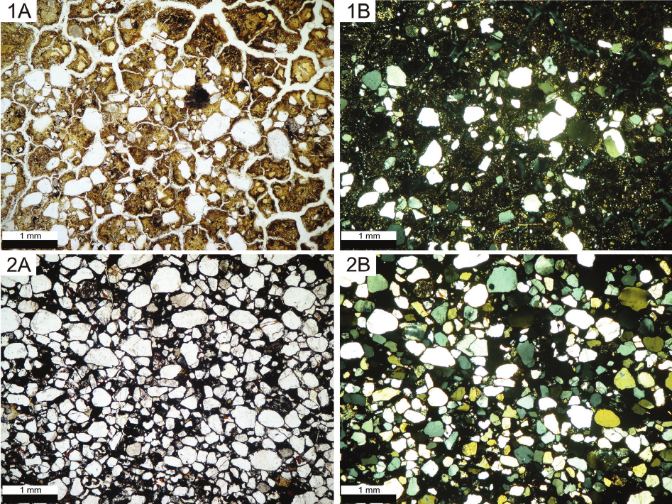
The cement in the sandstone is in the form of quartz
overgrowth and the black/brown mass seen in plane-po-
larized light (Fig. 22) is composed of iron-oxide miner-
als (hematite, goethite) mixed with very ne, plate-like
minerals (sericite and/or clay minerals). Their proportion
is variable. In many cases, iron-oxide minerals dominate
(samples 5, 6, 7, 13), whereas most samples (4, 8, 9, 10,
11, 12) have cement enriched in clay minerals.
Sample 4 is slightly dierent in comparison to most
of the other samples. It exhibited unusually high porosity
and, at the same time, a high content of cement (Table 1).
An exact microscopic analysis of the sample showed that
it is heavily cracked (Fig. 22) and the framework grains
are disseminated in an abundant ne-crystalline mass. The
latter shows a yellowish tint, and it is more translucent
than typical cement that is seen as black/brown in plane-
polarized light. The observed dierences presumably re-
sult from a signicant degree of weathering of the rock.
Scanning electron microscopy
Mapping analyses of representative areas of rock sam-
ples, as well as point analyses, show that some elements
are abundant and relatively evenly distributed in the rock,
while others occur in minor amounts and only in places.
Moreover, there are some correlations between certain
elements. Thus, silicon and oxygen are ubiquitous, while
iron, potassium, and aluminium occur less frequently. On
this basis, it can be concluded that the vast majority of the
framework grains are quartz. The locally observed con-
centrations of potassium, aluminium, silicon, and oxygen
correspond to sparse alkali feldspar grains. The occurrence
of aluminium is, as stated above, associated with alkali
feldspars, but this element is also located in the intergran-
ular spaces. Its occurrence is associated with the pres-
ence of silicon and oxygen bound together in platy clay
minerals composed of close kaolinite or montmorillonite
Constituent
Sample number
4 5 6 7 8 9 10 11 12 13
Quartz 29.4 66.4 60.1 57.8 68.2 58.8 56.7 62.7 65.4 64.0
Feldspar 0.8 6.3 6.2 6.7 3.7 5.7 5.6 2.8 9.8 5.4
Lithic grains 1.0 4.7 3.0 3.2 3.5 1.7 4.8 1.4 1.9 1.6
Pore 25.0 7.3 5.9 3.5 10.1 16.6 14.5 6.1 9.1 15.7
Cement 43.8 15.3 24.8 28.8 14.5 17.2 18.4 27.0 13.8 13.3
Table 1. Results of modal analysis in vol. % (elaborated by W. Bartz)
Fig. 21. Classification of investigated Samaipata sandstone samples
(elaborated by W. Bartz)
146 Wojciech Bartz, Jacek Kościuk, Maria Gąsior, Teresa Dziedzic
(smectite). Sporadically, this kind of platy clay additional-
ly contains small amounts of potassium or iron and mag-
nesium, representing illite, sericite, or chlorite crystals,
respectively. The iron is evenly distributed in the inter-
granular spaces and is associated with oxygen. It indi-
cates that the crystalline mass (the cement) lling the pore
spaces between the framework grains contains iron oxide
minerals – hematite, limonite, or goethite. Sporadically
observed and weak calcium bands found on a few EDS
spectra imply the presence of small amounts of calcite.
Thermal analysis
A strong endothermic eect was visible at 570 °C with
no associated weight loss. This was the result of the pol-
ymorphic transformation of quartz [18, p. 55], [19]. At
temperatures below 100 °C, a strongly marked weight
loss was visible on the DTG curve (rst derivative of the
weight curve), and this is associated with an endothermic
eect. It should be interpreted as the process of releasing
unbound (hygroscopic) water. Less common (samples 9,
8, and 10) was a poorly marked deection of DTG and
DDSC (rst derivative of the heat-ow curve), which was
visible slightly above the temperature of 100 °C. This can
be interpreted as the process of dehydration of clay mine-
rals (illite and/or smectite) and/or gypsum [18, pp. 83,
76–80, 125]. Another strong weight loss was observed in
the temperature range of 200–400 °C. This was accom-
panied by endothermic eects well marked on the DDSC
curve. Within this temperature range, iron oxyhydroxides
(goethite, lepidocrocite) undergo dehydroxylation [18,
pp. 64, 65], [19, p. 38]. Some of the samples (7, 8, 9, 10)
showed additional minor endothermic and weight loss ef-
fects within this temperature region. Presumably, this was
due to the occurrence of both forms of FeOOH – goethite
and lepidocrocite. The dehydroxylation temperature of
these minerals diers by several dozen degrees Celsius
[18, pp. 64–85]. A very strong weight-loss reaction was
also observed at a temperature close to 500 °C, and was
accompanied by an endothermic reaction. Clay minerals
undergo dehydroxylation at similar temperatures. A very
strong weight loss suggests their abundance. Depending
on the type of clay mineral, the peak temperature of the
weight-loss eect shifts, and for smectite is 680 °C, illite
550 °C, and kaolinite 520–590 °C [18, pp. 68–84], [19,
pp. 28–34]. Due to the fact that some of the samples clear-
ly showed reactions below 500 °C, it can be assumed that
kaolinite was present in the sample. The split-peak behav-
iour observed in a few samples suggests an overlapped
dissociation of two dierent phyllosilicates – kaolinite and
Fig. 22. Samaipata sandstone sample 4 (upper row) and sample 7 (bottom row)
viewed in plane-polarized light (A) and cross-polarized light (B)
(elaborated by W. Bartz)
Petrographic,mineralogical,climaticanalyses,riskmaps / Analizypetrograficzne,mineralogiczne,klimatyczne,mapyryzyka 147
illite. Some samples showed a relatively weak weight-loss
reaction with the associated endothermic reaction in the
temperature range of 630–660 °C. This could be inter-
preted as the result of the thermal dissociation of calcium
carbonates (calcite) with a low degree of crystallinity [18,
p. 108].
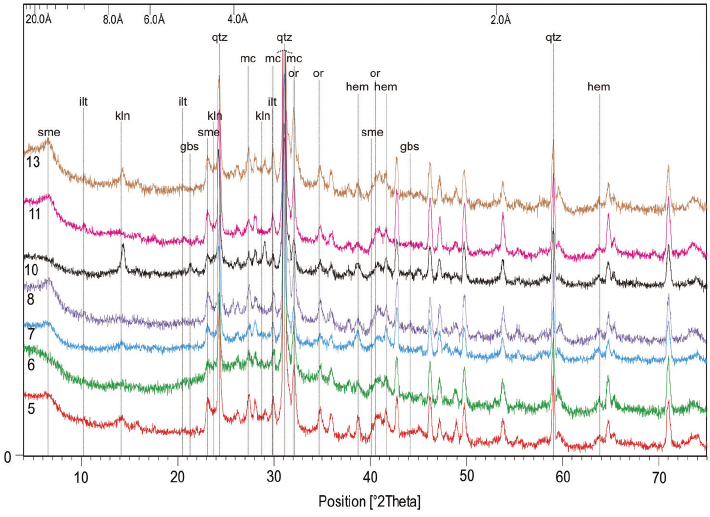
X-ray powder diffraction
The results showed the prevailing presence of quartz
due to the peaks at 3.34 Å, 4.25 Å, and 1.81 Å (Fig. 24).
Compared to quartz, less intense peaks were attrib-
uted to feldspar minerals – microcline and orthoclase,
evidenced by stronger peaks: 4.22 Å, 3.26 Å, 3.25 Å
and weaker peaks: 3.31 Å, 3.77 Å, 4.22 Å, respectively
(Fig. 23). Although the grains of minerals discussed be-
long to the frameworks and are relatively larger, a small
number of the nest fraction (the matrix) might have
passed through the sieve.
The next component identied by XRD was iron oxide
– hematite, representing the cement of the rock. Its pres-
ence is shown by the peaks observed at 2.70 Å, 2.52 Å,
and 1.69 Å (Fig. 23).
All of the obtained diraction patterns are marked with
peaks located at low 2Theta values: 10.10 Å, 7.18 Å, and
17.50 Å. They illustrate the presence of clay minerals: illite
(or structurally similar muscovite), kaolinite, and smectite,
respectively. Illite peaks were also found at 3.35 Å and
5.03 Å, while kaolinite peaks were found at 3.58 Å and
4.33 Å. Peaks located at 4.49 Å and 2.57 Å were attribut-
ed to smectite. Aluminium hydroxide (gibbsite) was also
identied on the basis of peaks 4.85 Å and 2.38 Å (Fig. 23).
The occurrence of crystalline phases within the ana-
lysed samples, identied by means of XRD, was strong-
ly varied. Quartz, alkali feldspar, hematite, illite (and/or
muscovite) were found in all samples. Unlike them, gibb-
site was very rare and was only found in sample 10. A fre-
quent constituent was clay minerals – kaolinite, identied
in samples 5, 7, 10, and 13 and smectite, found in samples
5, 7, 8, 11, and 13 (Fig. 23).
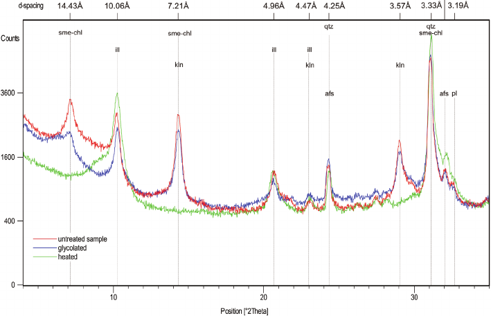
Properties of local clay
The clay fraction of the local clay material that could
potentially be used for restoration is a mixed-layer min-
eral – chlorite-smectite, kaolinite, and illite (or structur-
ally similar muscovite; Fig. 24). Illite was identied on
the basis of peaks at 10.06 Å, 3.33 Å, and 4.96 Å that
remained unaltered by ethylene glycol saturation and
heating to 550 °C. Kaolinite peaks were found at 7.21 Å,
3.57 Å, and 4.47 Å in the untreated sample and disap-
peared when the material was heated to 550 °C. The
mixed-layer smectite-chlorite was recognized on the basis
of peaks at 14.43 Å, 3.33 Å (overlapping with the most
intense quartz peak), and 7.21 Å. The small shift of peak
001 (d = 14.43 Å) after ethylene glycol saturation, visible
in the form of a wide peak at 15.5–17.5 Å, conrmed the
presence of the smectite layer. This particular peak shifted
to 8–10 Å when the sample was heated (Fig. 24).
As smectite is known to increase in volume many times
when watered and shrink when it dries, local clay is com-
pletely unsuitable for conservation purposes. Other clay
deposits need to be found, and their properties need to be
examined before using.
General conclusions and limitations
The formulation of strategies and detailed conservation
programs is not the purpose of this study. These must be
arranged by local specialists familiar with all local admin-
istrative and nancial conditions, as well as the availa-
bility of specic materials and conservation technologies.
Fig. 23. Results of XRD analysis
of sieved fraction <0.063 mm.
Mineral abbreviations:
sme – smectite, ilt – illite,
qtz – quartz, gbs – gibbsite,
kln – kaolinite,
or – alkali feldspar (orthoclase),
mc – alkali feldspar (microcline),
hem – hematite
(elaborated by W. Bartz)
148 Wojciech Bartz, Jacek Kościuk, Maria Gąsior, Teresa Dziedzic
References /Bibliografia
However, the analyses and data gathered above can be
used as a starting point for preparing detailed plans for the
long-term preservation of El Fuerte de Samaipata.
One recommendation can already be applied at this
stage. In light of the described climatic and topographic
factors, as well as the results of petrographic and mineral-
ogical analyses of local sandstone, it is necessary to consid-
er the problem of water retained in local depressions. Two
contradictory recommendations can be formulated for this:
– As smectite swells and shrinks, it is not advisable to
drain rainwater from all the depressions as soon as possi-
ble. Fast and frequent changes (watering and drying) will
promote the transformation of a smectite binder, which
would increase the volume of smectite and lead to faster
erosion of the rock. When considering only smectite, it is
advisable to leave the water in the depressions and allow
it to slowly evaporate.
Moreover, the contrary:
– The prolonged presence of water promotes the trans-
formation of the hematite binder into a ferric hydroxide
gel in the form of soluble oxyhydroxide, which causes
faster binder removal. From this point of view, it is essen-
tial to drain water from the depressions as soon as possi-
ble. The main part of the binder of Samaipata rock is he-
matite, and its dissolution seems to be the main reason for
the erosion of the rock.
Considering both recommendations and the reasons
behind them, it seems more important to drain water from
all depressions as soon as possible.
The size of the rock, its construction, chemical com-
position, position/location, and the multitude of destruc-
tive agents to which it is exposed create a combination
of factors that do not allow eective conservation and
maintenance procedures to be conducted that would ad-
equately protect this natural monument from destruction.
Only small-scale activities are possible for selected parts
of El Fuerte. One of the actions that could be taken and
which would delay the erosion of this valuable and unique
monument is to ll the main cracks in the rock that intensi-
fy erosion by allowing water to inltrate the rock. For this
purpose, it is possible to use mineral llers and binders rec-
ommended for the maintenance and conservation of stone
monuments [20]. This work should be carried out as a sep-
arate project under the guidance of an experienced stone-
art conservator and preceded by careful research and tests
on the use and application of suitable llers and binders.
Fig. 24. Results of XRD analysis
of oriented clay fraction mounts.
Mineral abbreviations:
sme-chl – smectite-chlorite,
ilt – illite, qtz – quartz,
kln – kaolinite, afs – alkali feldspar,
pl – Ca-Na feldspar
(elaborated by W. Bartz)
[1] De Alcaya D., Relación cierta [1636], [in:] I. Combès, V. Tyuleneva
(eds.), Paititi. Ensayos y documentos, Editorial Itinerarios, Cocha-
bamba 2011, 240–251.
[2] Ponce Sanginés C., Alcidesd’OrbignyysuviajeaSamaipataen1832,
[in:] R.D. Arze Aguirre (dir.), Elnaturalistafrancés,AlcideDessaline
d’Orbignyenlavisióndelosbolivianos, Institut Français d’Études
Andines, Plural editores, Lima–La Paz 2002 [1975], 307–315.
[3] Nordenskiöld E., ForschungenundAbenteuerinSüdamerika, Stre-
cker und Schroder, Stuttgart 1924.
[4] Pucher L., EnsayosobreelarteprehistóricodeSamaypata, “Revista
de la Universidad de San Francisco Xavier”, Universidad Mayor de
San Francisco Xavier Sucre, Sucre 1945.
[5] Alcázar de La Fuente R., El SitioCeremonialyAdministrativode
El Fuerte de Samaipata, “Tesape Arandu” 2015, Año 4, Nº 21, 1–9.
[6] Trimborn H., DerskulptierteBergvonSamaipata, “Archäologische
Studien in den Kordilleren Boliviens”, Bd. 3, “Baessler Archiv, Bei-
träge zur Völkerkunde” 1967, NF 5, 130–169.
[7] Meyers A., TrabajosArqueológicosenSamaipata,Departamentode
Santa Cruz, Bolivia,Primera Temporada 1992, “Boletín SIARB”
1993, Nº 7, 48–58, http://siarb-bolivia.org/wp-content/uploads/2019/
08/bol7a.pdf.
[8] Meyers A., Las Campañas Arqueológicas en Samaipata 1994–
1996.SegundoInformedeTrabajo, “Boletín SIARB” 1998, Nº 12,
59–86.

Petrographic,mineralogical,climaticanalyses,riskmaps / Analizypetrograficzne,mineralogiczne,klimatyczne,mapyryzyka 149
Abstract
El Fuerte de Samaipata is a pre-Hispanic archaeological site in Bolivia that has been on the UNESCO World Heritage List. Its main part – the rock
– is densely covered with a complex arrangement of terraces, platforms, water reservoirs, channels, and petroglyphs. The rapidly progressing erosion
of the rock is making the petroglyphs less and less clear, and some are no longer recognisable. The main topic of this study is to indicate all risk
factors conducive to erosion and to create risk maps identifying the most vulnerable areas that require immediate conservation intervention. Parallel
mineralogical and petrographic studies show that the Samaipata rock is a quartz-rich, porous, well-sorted sandstone, classied as quartz arenite
or subarcosic arenite. The cement of the rock is composed of quartz overgrowth and ubiquitous, pore-lling hematite-clay aggregates containing
non-expanding kaolinite, illite, and expanding smectite. The rock exhibits dierent stages of weathering, from relatively fresh to strongly altered and
heavily cracked. In comparison to fresh rock, the latter has cement enriched in clay minerals and is depleted in hematite due to weathering and the
dissolution of the iron-bearing phase.
Key words: Samaipata, conservation, climatic and topographical risk factors, sandstone, mineralogy
Streszczenie
El Fuerte de Samaipata to wpisane na Listę Światowego Dziedzictwa UNESCO prehiszpańskie stanowisko archeologiczne w Boliwii. Jego główna
część to skała ze złożonym układem tarasów, platform, zbiorników wodnych, kanałów i petroglifów. Szybko postępująca erozja sprawia, że petroglify
stają się coraz mniej wyraźne, a niektóre nie są już rozpoznawalne. Głównym tematem badań jest wskazanie wszystkich czynników ryzyka sprzyjają-
cych erozji oraz stworzenie map ryzyka identykujących najbardziej wrażliwe obszary wymagające natychmiastowej interwencji konserwatorskiej.
Badania mineralogiczne i petrograczne wskazują, że Samaipata to bogaty w kwarc, porowaty, dobrze posortowany piaskowiec, sklasykowany jako
arenit kwarcowy lub arenit subarkozowy. Spoiwo składa się z przerostu kwarcu i wszechobecnych, wypełniających pory agregatów hematytowo-
-gliniastych zawierających nierozprężający się kaolinit, illit i rozszerzający się smektyt. Skała wykazuje różne etapy wietrzenia, od stosunkowo świe-
żego do mocno zmienionego i mocno spękanego. W porównaniu ze świeżą skałą ta ostatnia ma cement wzbogacony w minerały ilaste i jest zubożona
w hematyt z powodu wietrzenia i rozpuszczenia fazy żelazonośnej.
Słowa kluczowe: Samaipata, konserwacja, klimatyczne i topograczne czynniki ryzyka, piaskowiec, mineralogia
Acknowledgements /Podziękowania
Thepresentedworkisa partof theresearch projectsponsoredbythe
grant given to the Wrocław University of Science and Technology by
thePolish NationalScience Centre(grant No.2014/15/B/HS2/01108).
Additionally, the municipality of Samaipata, represented by Mayor
FalvioLópesEscalera,contributedtothisresearchbyprovidingtheac-
commodationduringtheeldworkinJuneandJuly2016,aswellasin
July2017.TheMinistryofCultureandTourismofBoliviakindlygrant-
edallnecessarypermits(UDAMNo.014/2016;UDAMNo.060/2017).
The research was conducted in close cooperation with the Centre for
Pre-Columbian Studies of the University of Warsaw in Cusco. Spe-
cialists from many other universities and research centresalso joined
theproject.
[9] Meyers A., Reexiones acerca de la periodización de la Cultu-
ra Inka: perspectivas desdeSamaipata, Orientede Bolivia, [in:]
C. Diez Marín (ed.), ActasdelXIICongresoNacionaldeArqueo-
logíaArgentina, Editorial de la Universdad de la Plata, La Plata
1999, t. 1, 239–251.
[10] El Fuerte de Samaipata: Estudios arqueológicos, A. Meyers,
I. Combès (comp.), Biblioteca del Museo de Historia Universidad
Autónoma Gabriel René Moreno, Santa Cruz de la Sierra 2015.
[11] Combès I., Meyers A., El Fuerte de Samaipata en contexto: Es-
tudios históricos, Biblioteca del Museo de Historia Universidad
Autónoma Gabriel René Moreno, Santa Cruz de la Sierra 2018.
[12] Avilés S., ConservazionedeltempiodellaroccascolpitadiSamai-
pata–SantaCruz,Bolivia(Sudamerica), Tesi di Master: Universi-
tà di Bologna, Sede di Ravenna, Facoltà di Conservazione dei Beni
Culturali, Dipartimento di Storie e Metodi per la Conservazione dei
Beni Culturali, 2002, www.stonewatch.de/media/download/sc%20
04.pdf [accessed: 27.09.2017].
[13] Avilés S., IntroduzioneallaconservazionedellaRocciaScolpitadi
Samaipata, Bolivia, 2011, http://www.rupestreweb.info/samaipata.
html [accessed: 27.09.2017].
[14]
Avilés S., LaconservacióndelaRocaSagradadeSamaipata, [in:]
A. Meyers, I. Combès (comp.), El Fuerte de Samaipata: Estudios
arqueológicos, Biblioteca del Museo de Historia Universidad Autó-
noma Gabriel René Moreno, Santa Cruz de la Sierra 2015, 161–170.
[15] Elsen J., Microscopyofhistoricmortars–areview, “Cement and
Concrete Research” 2006, Vol. 36, Iss. 8, 1416–1424.
[16] Strzelczyk A.B., Karbowska-Berent J., Drobnoustroje i owady
niszczącezabytkiiichzwalczanie, Wydawnictwo Naukowe UMK,
Toruń 2004.
[17] Pettijohn F.J., Potter P.E., Siever R., Sand and sandstone, Springer-
Verlag, Berlin–Heidelberg–New York 1972.
[18] Földvári M., Handbook of thermogravimetricsystem of minerals
and its use in geological practice, Magyar Állami Földtani Intézet
(Geological Institute of Hungary), Budapest 2011.
[19] Wyrwicki R., Analiza derywatograczna skał ilastych, Wydaw-
nictwo Uniwersytetu Warszawskiego, Warszawa 1988.
[20]
Łukaszewicz J.W., Rodzajekamienisztucznych,właściwościorazod-
pornośćnadziałanieczynnikówniszczących, [in:] W. Do ma słowski
(red.), Zabytki kamienne i metalowe ich niszczenie i konserwacja
prolaktyczna, Wydawnictwo Naukowe UMK, Toruń 2011, 47–87.
Documenting petroglyphs
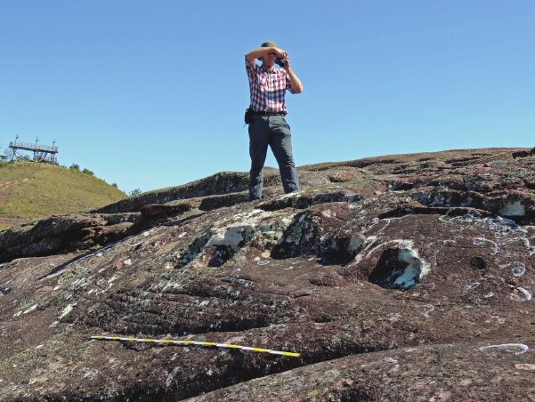
(photo by M. Ziółkowski)
Dokumentowanie petroglifów
(fot. M. Ziółkowski)