
2023
1(73)
Maciej Piekarski*
Topography of the 18
th
-century Rzeszów and its relics
in the contemporary architectural and urban space of the city
Introduction
The increased interest in regional history is one of the
current eects of civilizational development. Populariza-
tion of tourism resulting from the increase in the level of
education and wealth of the society is an important stim-
ulator. The self-promotion undertaken by local authorities
in order to compete for permanent residents constitutes an
extra motivation. The progress in the eld of digital tech-
nologies, which facilitates the dissemination of archives,
including by means of tools presenting their content in an
accessible and suggestive way, is one more catalyst for
this trend. Unfortunately, digital tools introduce a distance
between the place where the content is received and the
places pictured, which makes dicult to assess the mes-
sage. Undoubtedly, confrontation of historical content di-
rectly in the place of its creation has the greatest value.
Historical development of Rzeszów
Rzeszów is perceived as a new, dynamically develop-
ing city. Meanwhile, the documented history of the city
dates back to the 14
th
century. The views on the existence
of an earlier settlement in the place where Kazimierz
Wiel ki [Casimir the Great] founded the city in 1354 are
contradictory [1]–[4]. Also, the history of the early spatial
development of Rze szów is known only in outline [1]–[6],
mainly on the basis of the results of archaeological re-
search, because only one architectural object of medieval
origin has survived – the parish church of St. Wojciech
and Stanisław. In the early period of development, Rze-
szów covered the area of the present Market Square with
its adjacent areas, the parish church and the areas between
them. The convenient location of the city resulted from the
east-west communication route running through it and the
backwaters of the Wisłok River and the Mikośka Stream.
The rapid population growth prompted one of the owners
of Rzeszów, Mikołaj Rzeszowski, to locate, in the 16
th
centu-
ry
, directly to the north-east of then Rzeszów, the so-called
Nowe Miasto, a separate settlement inhabited mostly by
the Jewish community. The Nowe Miasto occupied the
space of the present Wolności Square and the buildings
surrounding it. The location of a fortied manor house in
the southern direction, occupying a dierent hill among
the backwaters of Wisłok and Mikośka, was the impulse
for further spatial development of Rzeszów. The manor
house, and later the castle, was connected to the city by
a road constituting the archetype of the main composi-
tional axis of historic Rzeszów, which is today’s 3 Maja
Street. The area around this road was building up gradu-
ally. In the years 1624–1629, Mikołaj Spytek Ligęza built
a Bernardine complex located north-west of the borders
of medieval Rzeszów, which initiated the spatial develop-
ment of the city in that direction [2]–[5].
From 1638 until the 1
st
half of the 19
th
century, Rzeszów
was owned by the Lubomirski family, who expanded the
city, founding excellent institutions and buildings. They
brought the Piarists, who in 1658 founded the College in the
city – an educational institution that has been continuously
functioning to this day in changing forms. For the needs of
the Piarist Order, at the turn of the 17
th
and 18
th
centuries
they rebuilt the earlier building housing the church, monas-
tery and college, giving it an architectural form close to the
current one. The designer was Tylman from Gameren, who
also designed the so-called summer palace. In the vicinity
of the castle and the summer palace, gardens were estab-
lished and a manor farm, stables and a kennel were built, as
well as another church and monastery – of the Reformati.
DOI: 10.37190/arc230102
Published in open access. CC BY NC ND license
* ORCID: 0000-0002-9788-1099. Faculty of Civil and Environ-
mental Engineering and Architecture, Rzeszow University of Technolo-
gy, Poland, e-mail: mgpiekar@prz.edu.pl
18 Maciej Piekarski
The residence and the town were surrounded from the west
by a set of ponds forming with the backwaters of Wisłok
owing around them from the east [2]–[5], a specic sys-
tem of fortications.
The general layout of 18
th
-century Rzeszów is known
from the so-called Wiedemann plan. The drawing, the
original of which is kept in the District Museum in Rze-
szów, is an icon of the city. On its basis, in 2002, a mockup
presented in the Museum of the History of the City of
Rze szów was made, and in 2004, a mural was placed on
the wall of one of the tenement houses. In 2022, an excur-
sion route was opened in the basement under the Rzeszów
Market Square, in which, after renovation and retrotting,
a multimedia story about the history of the city is present-
ed. The narrative is woven around the theme of the “city
on water”, inspired by the Wiedemann’s plan. However,
the visualizations presented there are a free vision of their
creator, unsupported by knowledge about the actual spa-
tial conguration of the Rzeszów backwaters.
18
th
-century Rzeszów
in the legacy of Karol Henryk Wiedemann
Karol Henryk Wiedemann was a German military en-
gineer and architect who came to Rzeszów in 1728 where
he designed and supervised the construction and modern-
ization of all major buildings in the city for 40 years as the
court architect of the Lubomirski family. He is also cred-
ited with designing the spatial arrangement around the
castle and the summer palace. Wiedemann, apart from his
legacy of strictly engineering works, went down in history
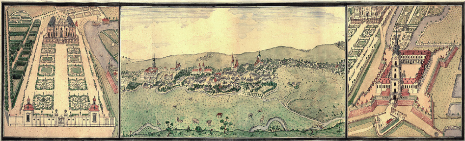
as a talented graphic artist, leaving behind two views of
Rzeszów. The rst one is in the form of a triptych (Fig. 1),
the middle part of which shows the city in a perspective
view from the east, and the left and right parts – the sum-
mer palace with a garden layout and the castle, respec-
tively. The triptych was probably made in the 1730s. The
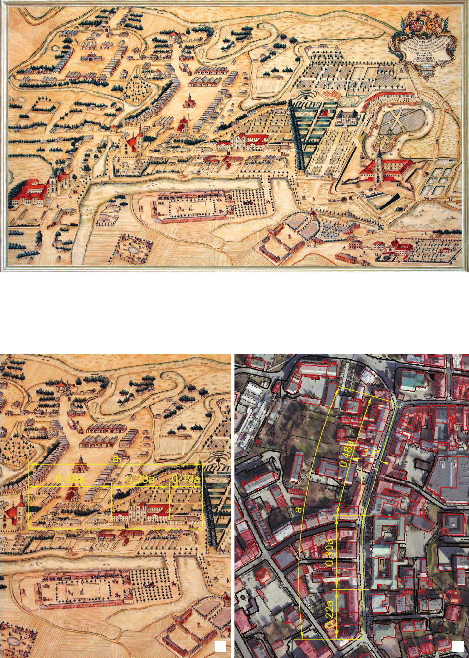
second view is the previously mentioned Wiedemann plan
from 1762. It presents the entire city in a perspective view
from the west (Fig. 2).
Previous researchers of the history of Rzeszów are full
of appreciation for Wiedemann’s precision and scrupulos-
ity expressed in the meticulous mapping of the city. Wie-
demann made his drawings in the times before the rst
balloon ight and the birth of photography. He relied only
on imagination constructing a bird’s-eye view of the city,
most likely not using geodetic measurements. The num-
ber of architectural objects in the view of Rzeszów from
1762 proves that he paid attention to details. However,
Wiedemann’s plan is burdened with errors leading to the
deformation of the image of the city. It seems that Wie-
demann began the construction of the view of Rzeszów
by determining the axis of Pijarska Street (now 3 Maja
Street), drawing it on the plane of the drawing as a hori-
zontal straight line, while the street, which has remained
unchanged to this day, is about halfway bent at an angle
of about 17°. Another mistake of Wiedemann was the in-
correct estimation of the length of the Piarist complex in
relation to the length of the entire Pijarska Street (Fig. 3a).
Although the school wing was shorter in his times than
it is today, the length ratio measured on the view from
1762 is greater than the ratio calculated on the basis of
measurements from the current map, taking into account
the extension of the school wing made in 1835 (Fig. 3b).
As a result of these mistakes, the image of the western part
of the city, including the ponds and the castle farm build-
ings, was signicantly deformed. The gardens located at
the back of the Piarist complex occupied on the drawing
a larger area than they actually did, and due to the lack of
space for a proper mapping of the later Różana Street (not
preserved to this day) and the buildings located along it,
its course was presented inconsistently with the facts. One
can discern Wiedemann’s conscientiousness, manifest-
ed in an internal order to count and show all the existing
buildings in the city, but other details of the drawings of
Rzeszów undermine the myth of his extraordinary accura-
cy or correct it with the conclusion that it was adequate to
the standards of the epoch.
The central part of the triptych shows a view of Rze-
szów, on which all signicant buildings of the city are
Fig. 1. Rzeszów triptych made by K.H. Wiedemann,
probably in the 1730s
(source: District Museum in Rzeszów, sign. MRH 2558)
Il. 1. Tryptyk rzeszowski wykonany przez K.H. Wiedemanna przypuszczalnie w latach 30. XVIII w.
(źródło: Muzeum Okręgowe w Rzeszowie, sygn. MRH 2558)
Topography of the 18
th
-century Rzeszów and its relics in the contemporary architectural and urban space of the city 19
Fig. 2. Perspective view of Rzeszów made by K.H. Wiedemann in 1762
(source: District Museum in Rzeszów, sign. MRH 2557)
Il. 2. Widok perspektywiczny Rzeszowa wykonany przez K.H. Wiedemanna w roku 1762
(źródło: Muzeum Okręgowe w Rzeszowie, sygn. MRH 2557)
Fig. 3. Spatial characteristics of Pijarska / 3 Maja Street:
a) on Wiedemann’s plan, b) on the current map (elaborated by M. Piekarski)
Il. 3. Charakterystyka przestrzenna ul. Pijarskiej / 3 Maja:
a) na planie Wiedemanna, b) na aktualnej mapie (oprac. M. Piekarski)
a b
20 Maciej Piekarski
the development of individual plots. Due to the imperfec-
tion of Wiedemann’s plan, as well as buildings extended
far beyond the area built-up in the 18
th
century and the in-
signicant dierences in the terrain ordinates, the research
was aimed at nding in current space any traces of the for-
mer terrain conguration, especially related to the location
of ponds. It was assumed that based on the ndings made,
conclusions will be formulated as to the impact of indivi-
dual urban planning activities undertaken in later times on
the change of this conguration. These conclusions could
be interpreted in a broader than local scope.
It was decided that due to the non-obvious connection
between the image of the city presented on Wiedemann’s
plan and the contemporary urban space of Rzeszów,
preserved documents from the intermediate periods, i.e.
maps, photographs and urban designs, will be analysed.
Topographic maps from the end of the 18
th
century to the
beginning of the 20
th
century, available online [11]–[13]
were obtained, as well as cadastral plans available in the
resources of the State Archives in Rzeszów [14]–[20] and
Przemyśl [21], including partly also online [21]. In ad-
dition, the study used aerial photographs from 1915 [22]
and 1944 [23] and an urban design from the early 2
nd
half
of the 20
th
century [24], located in the archives of the
Rzeszów City Development Oce, with fragments also
available in elaborations [25]–[27].
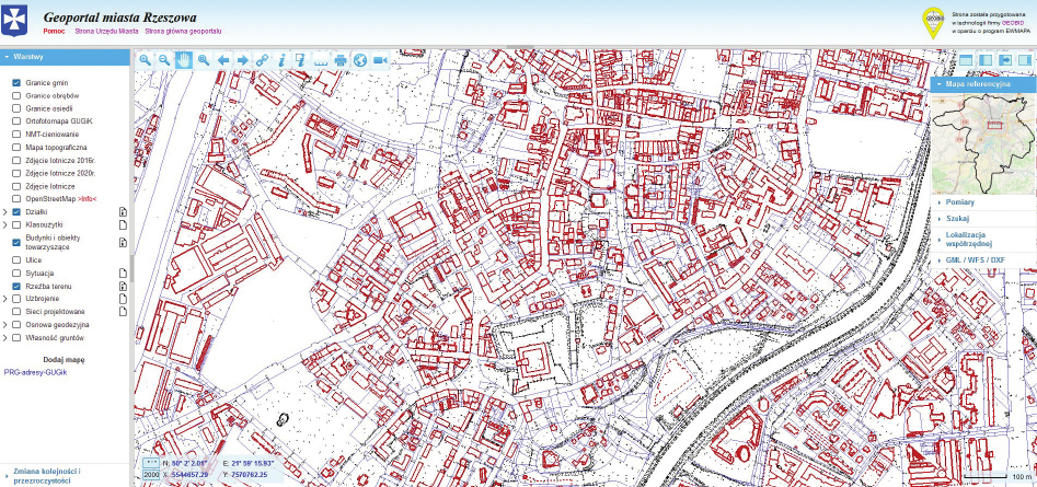
The current map available via the Geoportal of the city
of Rzeszów [28] was taken as the reference. The follow-
ing layers were used: Plots, Buildings and accompanying
objects, and Relief (Fig. 4). The layer of NMT-shading
was used supportingly. Similar data can be obtained from
the National Geoportal [29], which diers in the interface.
Data from the Geoportal were used to carry out compar-
ative studies with the matter of the historical cadastral
plan [15] and an aerial photography from 1915 [22]. In
addition, a tool available in the Geoportal for generating
visua lized. Their shapes dier from contemporary ones
due to later modernizations, but the location of the refor-
mats complex, as well as the number of windows in the
buildings, suggest that Wiedemann considered his work
as only a scheme, focusing on “counting” the objects, and
not on exact reproduction of their shapes and location.
The same is true of the view of the city in 1762. The num-
ber of axes in the monastery part of the Piarist complex,
unchanged to this day, calculated incorrectly (on Wiede-
mann’s plan 10, in fact 11) presented on it, gave rise to
divergent theories about the extent of the expansion of the
school wing in 1835 [4], [7]–[10].
It is hard to believe that the errors were Wiedemann’s
intention. It can even be assumed that he himself noticed
them while working. The abandonment of the correction
could have resulted from the state of advancement of the
work, which measures 120 × 180 cm, so it was created
over a longer period of time, as well as the purpose for
which it was made. The view of the city was supposed to
“please the eye” of Duchess Joanna Lubomirska, who was
the owner of Rzeszów at that time. Probably, her spatial
imagination was inferior to that of Wiedemann, and more-
over, the Duchess, spending time in the castle chambers
and gardens, did not know the topography of the city well.
Such a view of Rzeszów satised her ambitions.
Objectives and methods
of research work
Drawing attention to the obvious, though not com-
mented by anyone, inaccuracies in the mapping of the city
structure on Wiedemann’s plan in 1762, inspired the au-
thor to conduct research on the topography of the histori-
cal part of Rzeszów. The notion topography is understood
here as the landform and arrangement of areas with dier-
ent ways of development, without interest in the details of
Fig. 4. Geoportal of the city of Rzeszów with highlighted layers used during the research (source: [28])
Il. 4. Geoportal miasta Rzeszowa z wyróżnionymi warstwami wykorzystanymi w trakcie badań (źródło: [28])
Topography of the 18
th
-century Rzeszów and its relics in the contemporary architectural and urban space of the city 21
terrain cross-sections was used. The research was com-
plemented by a site visit in places so untransformed, that
as the analyses results conrm, some features of the land-
form from Wiedemann’s times are still retained there.
A photographic documentation was prepared during the
site inspection.
Analysis of documents representing Rzeszów
in times after Wiedemann
Rzeszów at the time of partitions
in cartographic documents
The cartographic resource from this period consists of
two types of maps: topographic maps and cadastral plans
[30]. Due to the fact that Rzeszów found itself in Austria
after the First Partition of Poland in 1772, the city and the
surrounding area were still within the reach of the Aus-
trian cartographic services in the 18
th
century. Exactly
during this period, work was underway on the so-called
Teresian-Josephine survey – a large-scale topograph-
ic map, drawn up in the years 1763–1785 in the scale
of 1: 28 800 and intended for military purposes [31].
On the fragment of the map (in the literature also re-
ferred to as Mieg’s map) covering Rzeszów, dating from
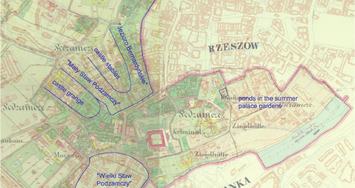
1779–1783 [11], three ponds on the western side of the
city, known from Wiedemann’s plan, are clearly visible
(Fig. 5a). According to the nomenclature given by Hennig
[10], they will be referred to as Jezioro Bernardyńskie (1),
Mały Staw Podzamczy (2) and Wielki Staw Podzamczy (3).
The view of this map leads to the reection that, despite
the meticulous, as for the scale used, quantitative map-
ping of the buildings, its spatial arrangement is not pre-
sented precisely enough. Pijarska / 3 Maja Street is not
only not marked on the map in accordance with its actu-
al curvature, it is even curved in the opposite direction.
This is partly the result of the imperfection of geodetic
measurements of the time, and partly due to insucient
diligence, because certain dependencies were noticeable
with the naked eye.
Other projects of Austrian cartography were the so-
called a Franciscan survey taken in 1806–1868 (Fig. 5b)
and a Franciscan-Josephine survey from 1868–1897. The
names of all three cartographic elaborations come from
the names of the then reigning Austrian emperors [31].
The second map was made in the same scale and tech-
nique as the rst one, while the third one was made in
the scale of 1: 25 000 and the monochrome convention.
The fragment of the second study covering Rzeszów
comes from the years 1861–1864 [12].
The map resulting from the second survey (Fig. 5b) is
developed with greater precision than the 18
th
-century map
(Fig. 5a). The course of Pijarska / 3 Maja Street is consis-
tent with the actual state. Neither Jezioro Bernardyńskie
nor Mały Staw Podzamczy can be seen anymore, the areas
after them are covered with greenery. Spatial outlines and
buildings of the castle grange and castle stables, as well as
the outline of the Wielki Staw Podzamczy are visible as
before. The place was no longer lled with water, but re-
mained undeveloped. The third survey [13] does not dier
from the second one [12] in terms of content, which is due
to the small distance between these two mappings.
The cadastral maps were made with a scale ten times
more precise (1:2880) than the topographic map. This
translated into a more detailed presentation of land use.
The map from 1842 [14] is the oldest, but the map from
1849 [21] is the most impressive due to its multi-co-
louredness. Beyond the ownership division, it contains
markings of buildings with the distinction of the material
from which they are made, and the arrangement of green-
ery. The map of Rzeszów [21] (Fig. 6a) does not include
all the areas described so far. The castle and the areas pre-
viously belonging to the residential complex were within
the boundaries of the Staroniwa commune. The cadas-
tral map of Staroniwa from 1849 is also preserved [15]
(Fig. 6b). It is drawn up exactly in the same convention as
the map of Rzeszów. The topography of the city presented
on both maps is similar to the one visible in the Josephine
survey, but due to the greater accuracy of the cadastral
maps, they are more valuable research material.
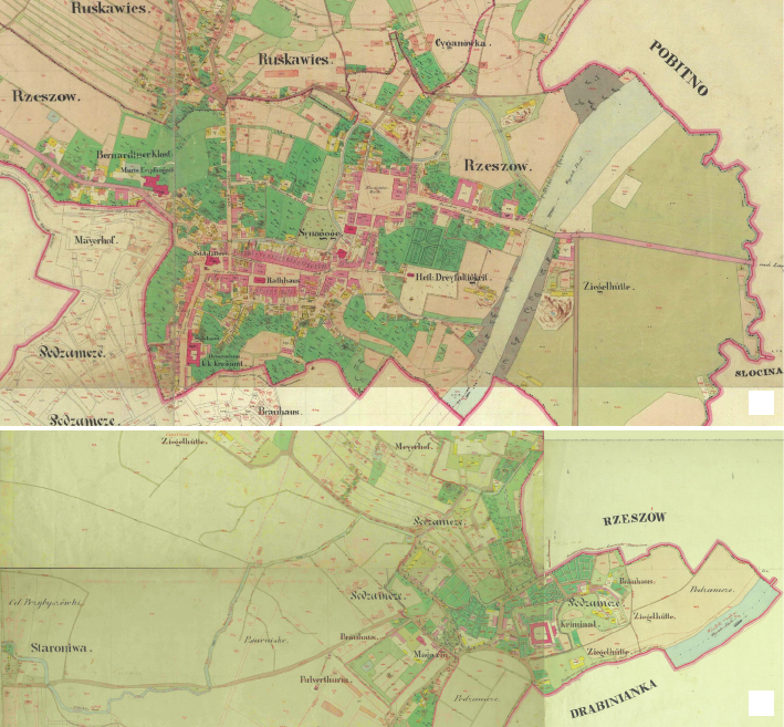
Fig. 5. Fragments of topographic maps from the time of the partitions:
a) Teresian-Josephine survey (1779–1783) (source: [11]), b) Franciscan survey (1861–1864) (source: [12])
Il. 5. Fragmenty map topograficznych z czasów rozbiorów:
a) zdjęcie terezjańsko-józefińskie (1779–1783) (źródło: [11]), b) zdjęcie franciszkańskie (1861–1864) (źródło: [12])
a b
22 Maciej Piekarski
In the later period of the Austrian rule, cadastral maps
of Rzeszów were developed several more times. Maps
from 1852 [16], 1879 [17], 1888 [18] and 1909 [19] have
been preserved in the State Archives in Rzeszów. New-
er maps are graphically poorer. The ones from the 19
th
century do not include the area around the castle, because
the Staroniwa commune was incorporated into Rzeszów
only in 1902. Although in the areas west of 3 Maja Street
at the turn of the 19
th
and 20
th
centuries new streets were
marked out and construction developed, the remains of
the former farm buildings of the Lubomirski family were
still clearly visible.
One more document dated 1829 [20], similar to the
map, has been preserved in the State Archives in Rzeszów.
It shows the layout and ownership of the real estate in the
south-western part of then Rzeszów. Presumably it was
prepared for scal purposes. The arrangement of individu-
al objects is marked schematically, but this diagram is still
a valuable supplement to the information we have about
19
th
-century Rzeszów.
Rzeszów from the 1
st
half of the 20
th
century
in aerial photographs
The development of aviation, initiated in 1903, togeth-
er with the development of photography, which had al-
ready been going on for several decades, provided new
opportunities for documenting the topography of the area.
World War I, during which the possibility of acquiring in-
formation about the enemy’s positions and the movements
of his troops by means of observations from air-planes
was appreciated, was the impulse for the development of
aerial photography. Warfare also aected Rzeszów, which
was alternately occupied by armies of warring powers. At
least three aerial photographs of Rzeszów, taken in 1915,
have been preserved, which today are privately owned
and are available to the general public only in low resolu-
tion [22], [32].
Another collection of aerial photographs of Rzeszów
comes from the period of World War II. Despite signi-
cant transformations in the land development compared
to the state from the 18
th
century, the photograph from
1944 [23] still provides a noticeable image of the build-
ings in the area of the former stables and the castle grange
consistent with Wiedemann’s plan. The area of the former
Wielki Staw Podzamczy is similarly noticeable.
Town planning documents
from the 2
nd
half of the 20
th
century
The location of the capital of the voivodeship in Rze-
szów in 1944 was an impulse for the dynamic development
of the city. The transformation plans within the historic
part of Rzeszów developed in the early post-war period
included several variants of solutions [25], [26], but all
of them assumed the routing through the city of commu-
nication arteries in the east-west and north-south, with
the task of taking over the car trac from the narrow
streets of the city centre. The main dierences between
the variants were in the way the north-south route was
Fig. 6. Cadastral maps from 1849:
a) map of Rzeszów (source: [21]),
b) map of Staroniwa (source: [15])
Il. 6. Mapy katastralne z 1849 r.:
a) mapa Rzeszowa (źródło: [21]),
b) mapa Staroniwy (źródło: [15])
a
b
Topography of the 18
th
-century Rzeszów and its relics in the contemporary architectural and urban space of the city 23
run, on the western or eastern side of the Bernardine mon-
astery and along then Marchlewski (pre-war Skarbowa/
Orlicz-Dreszer, now Lisa-Kuli) and Zamkowa Streets or
Mochnacki and Homanowa Streets. In each of the vari-
ants, the route entered the area of the former Jezioro Ber-
nardyńskie, which was still largely undeveloped.
Especially noteworthy are the spatial development
plans for Rzeszów carried out by Zbigniew Wzorek in
the years 1947–1953 [25]–[27]. The plans were aimed at
depriving the city of its small-town character and giving
it features adequate to obtain the rank of a provincial cap-
ital. Wzorek saw value in the 18
th
-century topography of
the city known from Wiedemann’s plan and strove for its
partial restitution, even regretting that reconstruction of
the water reservoirs surrounding the city, was not possi-
ble [27]. Wzorek’s plan was not implemented. Thus, the
spatial layout of the former castle stables was not recon-
structed, which, apart from providing the city with an
impressive urban interior, would allow for the preserva-
tion of the buildings of Zamkowa Street and the removal
of the north-south route from the oldest part of the city.
However, Wzorek’s plans to recreate the gardens in the
vicinity of the Lubomirski summer palace were less un-
derstandable. As the drawings show, the liquidation of the
Art Nouveau buildings on Aleja Pod Kasztanami and the
modernist buildings of Polski Czerwony Krzyż Street was
assumed. In the opinion of the contemporary residents of
Rzeszów, these parts of the city, due to these buildings
emanate genius loci to the greatest extent.
The results of Wzorek’s studies are drawings recon-
structing on the current map the urban structure present-
ed by Wiedemann. The reconstructions in the individual
drawings are not strictly identical, in some fragments the
interpretation is incorrect due to unreective reliance on
Wiedemann’s inaccurate drawing (Fig. 7a). This comment
applies especially to the excessively large area of gardens
in the summer palace complex. Also, the fanciful shape of
Wielki Staw Podzamczy (Fig. 7b) is not conrmed in the
topographic maps discussed in the point of Rzeszów at the
time of partitions in cartographic documents.
Confrontation of historical sources
with the current state
The potential of the current cartographic resource
Geoportal [28], [29] is an excellent research tool in the
eld of terrain. It enables a visual analysis of the content
of the Relief layer, which contains the elevations of points
and graphic marks of even low scarps. In addition, it en-
ables viewing of a digital terrain model, which is the eect
of 3D laser scanning (NMT-shading layer), as well as gen-
erating cross-sections along arbitrarily drawn broken lines.
Contrary to appearances, the view of the DTM brings
the least benets, because in the case of small dierenc-
es in ordinates, it is dicult to distinguish between the
terrain elevation, which is a remnant of its former shape,
and smoothness disturbances resulting from the intended
levelling around individual buildings, the location of en-
trances to sunken garages, etc. Viewing the Relief layer
is more ecient. Due to the fact that the scarp markings
were placed on it in a conscious way, they are an indication
of places where it is worth carrying out local visions. The
cross-sections, although misleading due to the unevenness
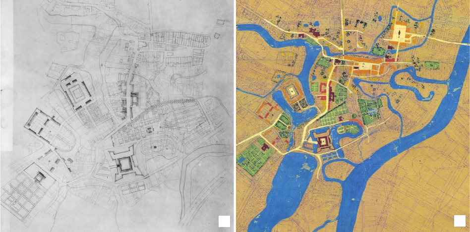
Fig. 7. Drawings for the general spatial development plan of Rzeszów by Z. Wzorek:
a) a study of the reconstruction of the historical urban layout of Rzeszów,
b) Rzeszów 1762 – a historical study
(source: [24], Biuro Rozwoju Miasta w Rzeszowie)
Il. 7. Rysunki do planu ogólnego przestrzennego zagospodarowania Rzeszowa autorstwa Z. Wzorka:
a) studium rekonstrukcji historycznego układu urbanistycznego Rzeszowa,
b) Rzeszów 1762 – studium historyczne
(źródło: [24], Biuro Rozwoju Miasta w Rzeszowie)
a
b
24 Maciej Piekarski
of the vertical and horizontal scales, may in turn conrm
the hypotheses derived from other sources. The map
available in the Geoportal, providing the ability to explore
in any conguration of layers, is also invaluable material
for confrontation with maps and historical photographs.
Analysis of aerial photographs
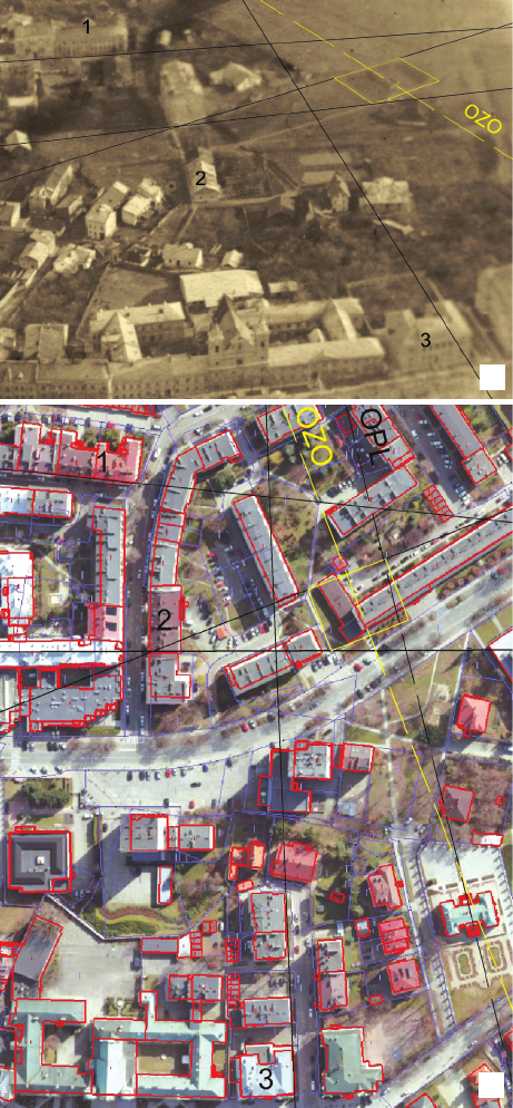
The purpose of the photos from 1915 [22], [32] was
not a photogrammetric mapping of the area, which is why
the shots are quite random, moreover, they cover only to
a small extent the fragments of the city that are the sub-
ject of consideration in this article. One of them shows the
view of two depressions in the area where, according to
Wiedemann’s plan, the gardens of the summer palace with
two ponds were located. This topographical detail, which is
barely noticeable on the cadastral map from 1849, is easier
to read on the photograph due the time of year in which
it was taken, because it was before the vegetation turned
green. The area in the immediate vicinity of the depressions
is undeveloped, but in the further surroundings there are
buildings existing to this day, which can be used to prepare
a geometric structure, leading to determinate the location of
the ponds in the current land arrangement. The transfer of
the structure from the archival photograph (Fig. 8a) to the
modern map (Fig. 8b) was based on the observation of to-
pological relationships and on approximate measurements
along the straight lines that are least deviated from the
perspective background, for which the deformation of the
distance is negligible. A fully precise design would require
taking into account, e.g. also the ordinates of the terrain,
and due to the low resolution of the photo and, consequent-
ly, the somewhat intuitive drawing of characteristic straight
lines on it, the eect would not guarantee correctness either.
The obtained result (Fig. 8b) proves that the axis of the
garden layout (OZO) was not an extension of the axis of
the summer palace (OPL), as suggested by Wiedemann’s
plan from 1762 (Fig. 2), although its bend is visible also on
it. The lack of parallelism of the compositional axes of the
parts of the gardens located in front of and behind the sum-
mer palace is clearly visible in the drawing, which is the
left part of the triptych (Fig. 1). Since its central part does
not show gardens at all, it can be assumed that the side parts
are designs that are yet to be implemented, while the view
from 1762 shows the eects of implementation. The bend
of the compositional axis was probably caused by terrain
conditions. Wiedemann, it seems, was an ecient designer,
but he was less successful in the eld of drawing construc-
tions. It is interesting that a few meters from the back edge
of the ponds, an escarpment with a height of approximately
0.8 m has been preserved to this day, both marked on the
map [28], [29] and visible in situ. The view in the aerial
photograph gives the impression that the pond basins were
not recessed in the ground, but formed as a result of being
surrounded by a dike. The modern trace may be related to
the earlier presence of ponds and dikes, and the slight dif-
ference in location is the result of land levelling performed
during the construction of the current buildings.
Superposition of maps
One of the ways that can be used to search for relics of
the former landform in the current topography of the city
is to overlay maps (Fig. 9). The study used the cadastral
map of Staroniwa from 1849 [15] (Fig. 6b). The date of
its creation is closest to the times of Wiedemann’s activity,
Fig. 8. Reconstruction of the location of the ponds in the garden
of the summer palace using an auxiliary planimetric structure:
a) aerial photo from 1915 (photo courtesy of J. Rudnicki),
b) contemporary map (1, 2, 3 – buildings used in the construction,
OZO – axis of the garden layout, OPL – axis of the summer palace)
(elaborated by M. Piekarski)
Il. 8. Odtworzenie położenia stawów w ogrodzie pałacu letniego
przy zastosowaniu pomocniczej konstrukcji planimetrycznej:
a) zdjęcie lotnicze z 1915 (zdjęcie dzięki uprzejmości J. Rudnickiego),
b) mapa współczesna (1, 2, 3 – budynki wykorzystane w konstrukcji,
OZO – oś założenia ogrodowego, OPL – oś pałacu letniego)
(oprac. M. Piekarski)
a
b
Topography of the 18
th
-century Rzeszów and its relics in the contemporary architectural and urban space of the city 25
Fig. 9. Superposition of
the cadastral map of Staroniwa
from 1849 (source: [15])
and the current map of Rzeszów
with the layers Plots and Buildings
and accompanying objects
(source: [28])
Il. 9. Superpozycja mapy
katastralnej Staroniwy z 1849 r.
(źródło: [15]) i aktualnej mapy
Rzeszowa z warstwami Działki
oraz Budynki i obiekty towarzyszące
(źródło: [28])
and at the same time its accuracy is satisfactory. The map
of Staroniwa is more accurate than the map of Rzeszów,
because the castle with its surroundings and a complex of
ponds and outbuildings were located within Staroniwa, not
Rzeszów. Although at the time of creation of the map wa-
ter reservoirs no longer existed, many composition prem-
ises known from Wiedemann’s plan were still preserved.
The historical map was superimposed on the current
map downloaded from the Geoportal (Fig. 4). The maps
were coordinated by adjusting the sections determined by
the points of two relatively distant objects: the post-Refor-
mat church and the summer palace. The accuracy obtained
is satisfactory, which proves the high craftsmanship of the
19
th
-century measurers. The experiment also conrmed
the results obtained in the analysis described in the section
Analysis of aerial photographs. A slight discrepancy results
from taking the rectangular shape of the troughs, because
such an impression is intuitively received from the pho-
tographs, while on the map they have trapezoidal shapes.
Analysis of the current master map
and terrain cross-sections
Based on the conclusions from the review of archival
maps and photographs as well as the analyses carried out,
the map available in the Geoportal was re-queried. Atten-
tion was paid to the vicinity of the edges of former water
reservoirs, assuming their location according to Figure 8.
Most traces of the historical topography of the city are
visible in the layer showing the ownership division of
the area. The lack of compliance concerns basically only
those places where expropriation for the construction of
roads or large-area buildings was carried out. As far as
the height variation is concerned, clear traces of the for-
mer topography are visible only in a few places, and the
dierences in current ordinates are probably smaller than
in the period when water reservoirs were located there.
In some places, the edges of the former ponds have been
softened as a result of lling in the bottom, in others they
are now vertical, as a result of levelling the surface of the
neighbouring plots to dierent levels. Plot borders, with
fences, retaining walls or walls of buildings preserved
along some of their fragments, walls of buildings on plots
with changed borders and scarps are the traces of the for-
mer shores (Fig. 10a – yellow). Some of the scarps are
shifted by several meters in relation to the indications in
the drawing, which is the result of local land levelling,
but the very fact of the escarpment’s presence seems to be
a consequence of historical topography.
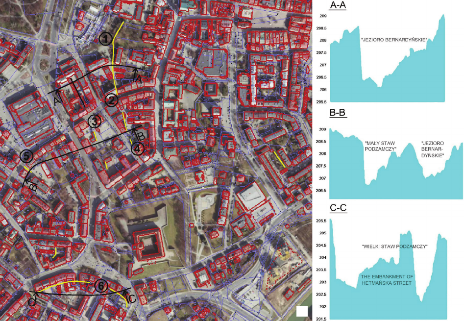
The historical topography is conrmed by the terrain
cross-sections (Fig. 10a – black). The reason for the defor-
mation of the expected shapes are the streets built in the
20
th
century, which, due to the class of the road, required
the use of thick structural layers. This is especially visible
on the C-C section (Fig. 10b), the formation of which re-
sults from the construction of Hetmańska Street on a high
embankment on the bottom of Wielki Staw Podzamczy.
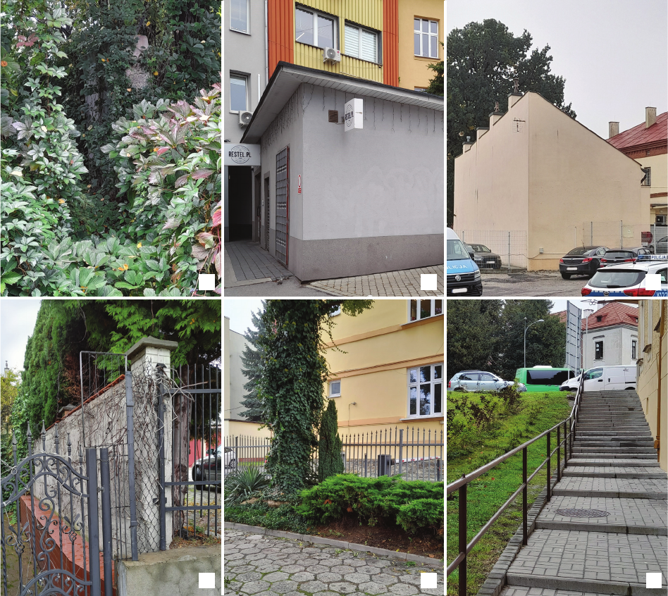
On-site inspection
The last stage of the research work was the visual veri-
cation of the results developed during the study work, car-
ried out on-site. Although the author of the study is a res-
ident of Rzeszów, the results of the research work were
partly surprising to him, because most of the established
traces of the former topography of the city are located in
places not visited on a daily basis, they are not unusual, and
moreover, their origin can be determined only as a result of
confrontation with archival materials. Figure 11 presents
photographs of selected places marked in Figure 10a.
Summary
The results of the research work allow for the formula-
tion of several conclusions of local importance which may
be of interest only to researchers and residents of Rze-
szów, but some conclusions are also of universal impor-
tance. One of the reections that comes to mind is the
statement of the insucient state of research on the urban
development of Rzeszów, which, due to its expansion, ab-
sorbed in the 20
th
and 21
st
centuries adjacent villages, pre-
viously constituting separate rural or manorial areas, with-
out the respect for their individuality. Existing studies are
based predominantly on text documents, and the analysis of
26 Maciej Piekarski
cartographic documents is inexact and not suciently re-
lated to the analysis of contemporary land use. The igno-
rance of this aspect in the previous studies is partly justi-
ed by the greater diculty in using cartographic material
at a time when it could not yet be available in digital form.
The research carried out extends the available stock of
knowledge with a new particle, based on analyses using
modern geoinformatic technologies. It is important both
for researchers and for residents because it can have a pos-
itive impact on the feeling of being rooted in a given area,
and thus strengthening the social bonds in the local com-
munity. The author bases his reection on the observation
of thematic walks around Rzeszów organized in recent
years by various cultural institutions, which enjoy con-
siderable interest of the inhabitants, often exceeding the
organizers’ expectations. Finding the past in the present,
through the assimilation of historical artefacts palpable in
the city space despite the passage of time, has also the
potential to build a comforting view of the future as a state
in which traces of the current present will also be kept.
The main goal set at the beginning of the research, i.e.
nding traces of water reservoirs surrounding 18
th
-century
Rzeszów, has been achieved. However, this does not mean
that the location of these reservoirs has been fully estab-
lished. The search will continue. With regard to Rzeszów,
a broader analysis of the arrangement of elements shap-
ing the topography of Staroniwa and other villages that
are currently part of Rzeszów can be adopted as the next
research goal, due to the availability of rich cartograph-
ic collections in the archival resources. Areas not previ-
ously covered with buildings or built only with wooden
buildings, not preserved to this day, will cause diculties.
The coordination of historical maps with the contempo-
rary map will require a dierent method of proceeding,
i.e. finding permanent topographic objects other than
buildings. The method of overlapping maps as a tool for
nding in the terrain the location of objects shaping its
historical topography can be a universal method, provided
that the detailed procedure is adapted to local conditions.
In general terms, research on the transformation of the
city’s topography draws attention to the terrain as an ele-
ment of the cultural landscape, which is still poorly per-
ceived in the issues of heritage protection. The changes de-
scribed in the article took place either in the 19
th
century,
Fig. 10. Recognized traces of shorelines of former ponds in the current structure of the city:
a) a projection from the Geoportal with the marking of shoreline fragments (yellow), terrain cross-sections (black)
and places in which the photos included in Fig. 11 have been taken (circled numbers),
b) terrain cross-sections
(elaborated by M. Piekarski)
Il. 10. Rozpoznane ślady linii brzegowych dawnych stawów we współczesnej strukturze miasta:
a) rzut z Geoportalu z oznaczeniem fragmentów linii brzegowych (kolor żółty), przekrojów terenu (kolor czarny) oraz miejsc,
w których wykonane zostały fotografie składające się na il. 11 (numery w kółkach), b) przekroje terenu
(oprac. M. Piekarski)
a
b
Topography of the 18
th
-century Rzeszów and its relics in the contemporary architectural and urban space of the city 27
Fig. 11. Traces of shores of 18
th
-century water reservoirs:
a) wall (marked as 1 in Fig. 10a), b, c) walls of buildings (marked as 2 and 3 in Fig. 10a), d) fence (marked as 4 in Fig. 10a),
e) low escarpment (marked as 5 in Fig. 10a), f) high escarpment (marked as 6 in Fig. 10a)
(photo by M. Piekarski)
Il. 11. Ślady brzegów XVIII-wiecznych zbiorników wodnych:
a) mur (na il. 10a oznaczony jako 1), b, c) ściany budynków (na il. 10a oznaczone jako 2 i 3), d) ogrodzenie (na il. 10a oznaczone jako 4),
e) skarpa niska (na il. 10a oznaczona jako 5), f) skarpa wysoka (na il. 10a oznaczona jako 6)
(fot. M. Piekarski)
a
d
b
e
c
f
when the liquidation of ponds was a remedy for the man-
agement of the material from excavations for new build-
ings, the need for new investment areas, as well as sanitary
nuisances, or in the 20
th
century, when the priority of the
city’s development was overriding, which is conrmed by
ignoring the plans developed by Zbigniew Wzorek. The
lack of respect for the terrain conguration as an element
shaping the city’s identity was also characteristic of later
periods, as well as it is recently. Against the background
outlined above, the issue of ownership division of land
looks better. In places not aected by land consolidation
for large-area public investments, the cadastral division of
the area remains unchanged even for centuries, sometimes
only in the form of a drawing on the map, no longer re-
ected in the physical divisions of space.
Translated by
Maciej Piekarski
Acknowledgements
Many thanks to Mr. Jacek Rudnicki for providing a digital version of
the photograph of Rzeszów from 1915, which helped me to make a more
accurate geometric construction.
28 Maciej Piekarski
Abstract
Topography of the 18
th
-century Rzeszów and its relics
in the contemporary architectural and urban space of the city
One of the icons of Rzeszów is the 18
th
-century perspective view of the city, known as the Wiedemann plan. The view shows the buildings and
topography of the city, which was then surrounded by a system of ponds and backwaters. All representative buildings have been preserved to this day,
although in slightly changed forms. Ponds and backwaters do not exist.
The study described in the article was aimed at nding traces of the shores of these water reservoirs in the modern topography of the city, which
is very much transformed. Maps and aerial photographs from the times when traces of the 18
th
-century topography were more visible were used
for this purpose. The content of cartographic sources was used by overlaying digital versions of maps: historical and current, calibrating the image
using a pair of points belonging to two distant objects with unchanged shapes. The information contained in the photograph was veried by making
analogous geometric constructions on the photograph and on the current map. The culmination of the study was an in-situ reconnaissance. Many still
clear traces of the former topography were found in the area, which may be imperceptible to an outside observer.
The obtained results introduce a correction to the Wiedemann’s plan, which mapped the spatial structure of the city partly incorrectly. They sup-
plement the knowledge base about Rzeszów, which does not suciently cover spatial and urban issues. They draw attention to the ignored element
of the urban cultural landscape, which is the topography, often insuciently protected.
Key words: urban planning, Rzeszów, heritage protection, topography
References
[1] Kotula F., Tamten Rzeszów, MITEL, Rzeszów 2003.
[2] Dzieje Rzeszowa, F. Kiryk (red.), t. 1, Krajowa Agencja Wydawni-
cza, Rzeszów 1994.
[3] Malczewski J., Dzieje Rzeszowa do roku 1914, Muzeum Okręgo-
we, Rzeszów 1985.
[4] Encyklopedia Rzeszowa, J. Draus, G. Zamoyski (red.), Ocyna
Wydawnicza “Zimowit”, Rzeszów 2016.
[5] Kwolek J., Malczewski J., Historia i rozwój przestrzenny Rzeszo-
wa od powstania do współczesności, “Renowacje i Zabytki” 2015,
nr 3(55), 44–63.
[6]
Mącik H., Ulica 3 Maja w XVII–XX wieku, [in:] J. Rogóż, H. Mącik
(red.),
Ulica 3 Maja w Rzeszowie, Wydawnictwo UR, Rzeszów 2019,
67–102.
[7] Ochenduszko T., Dzieje Rzeszowa do 1918 roku. Kalendarium,
MITEL, Rzeszów 2006.
[8] Kłos S., Rzeszów. Przewodnik, Krajowa Agencja Wydawnicza,
Rzeszów 1993.
[9] Świeboda J., Collegium Resoviense w życiu Polaków 1658–1983,
Rzeszowskie Zakłady Graczne, Rzeszów 1983.
[10] Hennig W., Rzeszowski alfabet miejsc często zapomnianych i osób
z nimi związanych, Podkarpacki Instytut Książki i Marketingu,
Rzeszów 2012.
[11] Galizien und Lodomerien (1779–1783), https://maps.arcanum.
com/en/map/rstsurvey-galicia [accessed: 18.03.2023].
[12] Galicia and Bucovina (1861–1864) – Second military survey of the
Habsburg Empire, https://maps.arcanum.com/en/map/secondsur-
vey-galicia [accessed: 20.03.2023].
[13] Habsburg Empire (1869–1887) – Third Military Survey (1:25000),
https://maps.arcanum.com/en/map/thirdsurvey25000 [accessed:
20.03.2023].
[14] Plan miasta Rzeszowa z 1842 roku, [manuscript in: AP, Rzeszów,
sign. 59/1/0/8/1151].
[15] Dorf Staroniwa sammt den Ortschaften Podzamcze, Wygnaniec,
Psiarnisko und Rudki in Galizien, Rzeszower Kreis, [1849–1852],
[manuscript in: AP, Rzeszów, sign. 59/1313/0/-/3292].
[16] Stadt Rzeszow in Galizien, Kreis Rzeszow, [1852], [manuscript in:
AP, Rzeszów, sign. 59/1313/0/-/2073].
[17] Stadt Rzeszow in Galizien, [1879], [manuscript in: AP, Rzeszów,
sign. 59/1/0/8/1152].
[18] Miasto Rzeszów w Galicji, [1888], [manuscript in: AP, Rzeszów,
sign. 59/1313/0/-/3404].
[19] Miasto Rzeszów w Galicji, [1909], [manuscript in: AP, Rzeszów,
sign. 59/1313/0/-/3407].
[20] Ideal Plan des sundlischen Thailes der Stadt Rzeszow, [1829],
[manuscript in: AP, Rzeszów, sign. 59/1/0/8/1150].
[21]
Stadt Rzeszow sammt Enclave Ruska Wieś in Galizien Rzeszower
Kreis, [1849], [manuscript in: AP, Przemyśl, sign. 56/126/0/-
/1468M].
[22] Rudnicki J., Rzeszów. Rok 1915. 100 rocznica odbicia miasta z rąk
Rosjan. Epizod Wielkiej Wojny, Libra, Rzeszów 2015.
[23] 20 sierpnia 1944, Rzeszów. GX4143 F2954 SD. Ogniskowa 755 mm,
skala 1:12 000, Zdjęcie #105, https://fotopolska.eu/Rzeszow_Z?f=-
1279961-foto [accessed: 20.03.2023].
[24] Wzorek Z., Studia do planu ogólnego Miasta Rzeszowa i Planu
Szczegółowego Śródmieścia 1947–1953, [manuscript in: Archi-
wum Biura Rozwoju Miasta Rzeszowa].
[25] Moskal T., Wpływ założeń Ogólnego Planu Zabudowania miasta
Rzeszowa z 1939 roku na dokumenty planistyczne miasta w latach
1939–2003, PhD thesis, Politechnika Krakowska, Kraków 2018.
[26] Moskal T., Problematyka kształtowania śródmieścia miasta. Studia
nad rozwojem przestrzennym Rzeszowa, “Przestrzeń/Urbanistyka/
Architektura” 2020, Vol. 2, 125–147, doi: 10.4467/00000000PUA
.20.013.13062.
[27] Wzorek Z., Rzeszów – studia do planu śródmieścia, “Miasto” 1953,
9(35), 21–25.
[28] https://osrodek.erzeszow.pl\ [accessed: 20.03.2023].
[29] https://mapy.geoportal.gov.pl [accessed: 20.03.2023].
[30] Malczewski J., Dawne plany, mapy i widoki Rzeszowa, Muzeum
Okręgowe, Rzeszów 1985.
[31] Faluszczak F.P., Kartograa Galicji Wschodniej w latach 1772–
1914, Wydawnictwo UR, Rzeszów 2011.
[32] 1915, Rzeszów w Galicji. Zdjęcie lotnicze z wysokości 1400 m,
https://fotopolska.eu/Rzeszow_Z?f=1688371-foto [accessed:
20.03.2023].
Topography of the 18
th
-century Rzeszów and its relics in the contemporary architectural and urban space of the city 29
Streszczenie
Topograa XVIII-wiecznego Rzeszowa i jej relikty
we współczesnej przestrzeni architektoniczno-urbanistycznej miasta
Jedną z ikon Rzeszowa jest XVIII-wieczny widok perspektywiczny miasta, znany jako tzw. plan Wiedemanna. Na widoku przedstawione są
budynki oraz topograa miasta, które było wówczas otoczone systemem stawów i rozlewisk. Wszystkie reprezentacyjne budynki, chociaż w nieco
zmienionych formach, są zachowane do dzisiaj. Stawy i rozlewiska nie istnieją.
Celem autora w badaniu opisanym w artykule było odnalezienie śladów po brzegach tych zbiorników wodnych we współczesnej topograi mia-
sta, która jest bardzo zmieniona. Posłużono się do tego mapami i fotograami lotniczymi z czasów, kiedy ślady XVIII-wiecznego ukształtowania
terenu były bardziej widoczne. Treść źródeł kartogracznych wykorzystano poprzez nałożenie na siebie cyfrowych wersji map: historycznej oraz
aktualnej, kalibrując obraz za pomocą pary punktów przynależnych do dwóch oddalonych od siebie obiektów o niezmienionych bryłach. Informację
zawartą w fotograi zwerykowano poprzez wykonanie analogicznych konstrukcji geometrycznych na fotograi oraz aktualnej mapie. Zwieńcze-
niem badania był rekonesans in situ. W jego trakcie znaleziono w terenie wiele wciąż wyraźnych śladów dawnej topograi, które dla postronnego
obserwatora mogą być niezauważalne.
Uzyskane rezultaty wprowadzają korektę do planu Wiedemanna, odwzorowującego strukturę przestrzenną miasta częściowo błędnie. Uzupełnia-
ją stan wiedzy o Rzeszowie, która w niedostatecznym stopniu obejmuje zagadnienia przestrzenno-urbanistyczne. Zwracają uwagę na ignorowany
element miejskiego krajobrazu kulturowego, jakim jest ukształtowanie terenu, często niedostatecznie chronione.
Słowa kluczowe: urbanistyka, Rzeszów, ochrona dziedzictwa, topograa